
 English
 Français

Vanbrugh College, York
Vanbrugh College is one of the eleven colleges of the University of York.

Drummer Hill Farm
Drummer Hill Farm is a historic farm near Ingleby Greenhow, a village in North Yorkshire, in England.
The Victoria County History describes the parish of Ingleby Greenhow as "a desolate and thinly-populated region", but it does support several farms. Drummer Hill Farm has supported a mixture of arable and livestock farming. The principal interest is in a range of outbuildings. A barn and attached cart lodge with a granary above were constructed in the early 19th century, followed in the middle of the century by an engine house. The granary was later converted into a hay loft. The building was grade II* listed in 1990.
The buildings are constructed of stone and some red brick, with an eaves band, and a pantile roof with a stone ridge and coping. The barn is of four bays and has a gabled engine house, and the cart lodge has three bays. On the front are external steps, and the openings include two elliptical arched entrances, slit vents and a stable door. Inside the engine house is a rare example of a horse engine in its original location. It consists of a wheel on a stone base, with an iron post in the centre, and wooden braces which connect with the crossbeams.

NHS Nightingale Hospital Yorkshire and the Humber
The NHS Nightingale Hospital Yorkshire and the Humber was one of the temporary NHS Nightingale Hospitals set up by NHS England in 2020 to help to deal with the COVID-19 pandemic. The hospital was constructed inside the Harrogate Convention Centre, Harrogate, and from 4 June 2020 was repurposed as a radiology diagnostic clinic.
In March 2021, it was confirmed the hospital would close.

Whittingham railway station (Northumberland)
Whittingham railway station served the village of Whittingham, in Northumberland, England from 1887 to 1953. It was a stop on the Cornhill Branch, which connected Coldstream with Alnwick.

Grange in Borrowdale
Grange, often called Grange in Borrowdale, is a village in Borrowdale in the English Lake District. It lies just off the B5289 road to the south of Derwent Water and 4 miles (6.4 km) south of Keswick, in the county of Cumbria, historically part of Cumberland,
The village is overlooked by Grange Fell and Castle Crag, which flank either side of the narrow section of Borrowdale in which it sits. Its origins date back to medieval times, when the monks of Furness Abbey built a monastic grange on the site. The double-arched bridge that links the village to the B5289 across the River Derwent was built in 1675. Holy Trinity Church followed in 1861.
The novelist Hugh Walpole owned Brackenburn, a large house about 1 mile (1.6 km) to the north of Grange, and lived there from 1924 until his death in 1941.

Trinity Church, Barrow-in-Furness
Trinity Church was a Presbyterian church located on School Street in Barrow-in-Furness, England.
It is not the same building as the joint Methodist and URC church in Parkside, Barrow-in-Furness known as the Trinity Church Centre.
Ashton Town F.C.
Ashton Town Football Club is a football club based in Ashton-in-Makerfield, Greater Manchester, England. The club are currently members of the North West Counties League Division One North and play at Edge Green Street.

Craigleith, Edinburgh
Craigleith (Scottish Gaelic: Creag Lìte) is an area of west Edinburgh, Scotland. Its name comes from various forms of Craig of Inverleith, or rock or hill of Inverleith. The area lies between Ravelston Dykes, to Crewe Toll and the Ferry Road, and Comely Bank on the east. Queensferry Road and Craigleith Road both pass through here. There are also a number of private schools in the area such as Stewart's Melville College and The Mary Erskine School.
The Royal Victoria Hospital is off Craigleith Road while the Western General Hospital on Crewe Road was opened in 1868 as the Craigleith Hospital and Poorhouse.

Port Salford
Port Salford is a freight terminal on the banks of the Manchester Ship Canal in Barton-upon-Irwell, Greater Manchester, England, 6 miles (9.7 km) west of Manchester city centre. The port is part of the Atlantic Gateway project and its construction was led by Peel Ports, a subsidiary of the Peel Group, and was opened in 2016.
Port Salford cost £400 million to construct.

Earl de Grey, Kingston upon Hull
The Earl de Grey is a pub constructed in the early 19th century in the centre of Kingston upon Hull, England. The building is three storeys high with a slate roof. It had green faience (tiling) covering the front of the ground floor, which was added around 1913, decorated with Ionic pilasters. Cream-coloured fascia above the ground-floor windows featured "EARL DE GREY" signage.
The first records of the pub appear in 1831, when it was originally named "Junction Dock Tavern"; it was renamed in the 1860s after the Earl de Grey at the time, George Robinson, 1st Marquess of Ripon. The Earl de Grey was popular with seafarers, being located close to the docks and in what was at the time Hull's red-light district.
The faience of the ground floor was likely added around 1913, when the interior was renovated by the then owner, Bentley's Yorkshire Brewery. The exterior of the building was given grade II listed status for its historic value in 1994. Since then, it has had extended periods of closure and disuse.
According to a local legend, in the 1980s, the pub was home to two parrots, Cha Cha and Ringo. A burglar broke in, and fearing that the parrots would alert the pub's landlord, stabbed Cha Cha to death. Following the ordeal, Ringo never spoke again. The two parrots are thought to be buried nearby.
In 2018, property developer Wykeland announced that the Earl de Grey would be moved to make room for redevelopment of Castle Street. The Earl de Grey's new location is about 100 feet (30 m) west of where it stood originally. The front of the building was disassembled and placed into storage in 2020. Reconstruction work at a new site on Waterhouse Lane began in January 2024 and is due to be completed in 2025, forming part of a restored Castle Street Chambers.

Bust of Carlo Antonio del Pozzo
The Bust of Carlo Antonio del Pozzo is a sculptural portrait by the Italian artist Gianlorenzo Bernini. It is in the National Gallery of Scotland, Edinburgh. Carlo Antonio was the Archbishop of Pisa and the uncle of the noted seventeenth-century collector, Cassiano del Pozzo, who commissioned Bernini to create the sculpture.
It was acquired by the National Gallery of Scotland in 1986, at a cost of 3m British Pounds, although the value at the time was said to be much higher (around 7.5m pounds). It had previously been in the British stately home of Castle Howard, since 1715.

Selby railway station
Selby railway station is a Grade II listed station which serves the market town of Selby in North Yorkshire, England. The original terminus station was opened in 1834 for the Leeds and Selby Railway. The Hull and Selby Railway extended the line in 1840 and a new station was built, with the old station becoming a goods shed. The station was rebuilt in 1873 and 1891; the 1891 rebuilding was required due to the replacement of the swing bridge over the River Ouse at the same time.
The area around the station is a junction for a number of lines, including the former East Coast Main Line route between Doncaster and York, the Selby to Driffield Line (1848) and the Selby to Goole Line (1910). After 1983, with the opening of the Selby Diversion, Selby is no longer on the East Coast Main Line.
As of 2014, lines lead from Selby to Leeds, Hull and Doncaster. The station is managed by TransPennine Express and receives regional trains operated by Northern and TransPennine Express, as well as Hull-London services operated by Hull Trains and London North Eastern Railway.
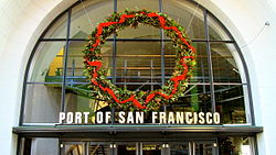
Port of San Francisco
The Port of San Francisco is a semi-independent organization that oversees the port facilities at San Francisco, California, United States. It is run by a five-member commission, appointed by the mayor subject to confirmation by a majority of the San Francisco Board of Supervisors. The Port is responsible for managing the larger waterfront area that extends from the anchorage of the Golden Gate Bridge, along the Marina district, all the way around the north and east shores of the city of San Francisco including Fisherman's Wharf and the Embarcadero, and southward to the city line just beyond Candlestick Point. In 1968, the State of California, via the California State Lands Commission for the state-operated San Francisco Port Authority (est. 1957), transferred its responsibilities for the Harbor of San Francisco waterfront to the City and County of San Francisco/San Francisco Harbor Commission through the Burton Act AB2649. All eligible state port authority employees had the option to become employees of the City and County of San Francisco to maintain consistent operation of the port of San Francisco.
The port of San Francisco lies on the western edge of the San Francisco Bay near the Golden Gate. It has been called one of the three great natural harbors in the world, but it took two long centuries for navigators from Spain and England to find the anchorage originally called Yerba Buena: a port, as was said in its early days, in which all the fleets of the world could find anchorage.
The port area under the commission's control comprises nearly eight miles of waterfront lands, commercial real estate and maritime piers from Hyde Street on the north to India Basin in the southeast. The list of landmarks under port control include Fisherman's Wharf, Pier 39, the Ferry Building, Oracle Park (formerly AT&T Park, SBC Park and Pacific Bell Park), located next to China Basin and Pier 70 at Potrero Point. Huge covered piers on piles jut out into San Francisco Bay along much of the waterfront, bordered by the Embarcadero roadway. In 2015, the city, acting through the port of San Francisco, launched the San Francisco Seawall Earthquake Safety and Disaster Prevention Program (Seawall Program).

St Hilda's Church, Hinderwell
St Hilda's Church is the parish church of Hinderwell, a village in North Yorkshire, in England.
A church was built on the site in the Saxon period, and rebuilt in the 12th century. There is a holy well in its churchyard. The old church was demolished and the current church was built in 1773, while the tower was rebuilt in 1817. The church was restored in 1895, and was grade II listed in 1969.
The church is built of stone with a Welsh slate roof, and consists of a nave, a chancel and a west tower. It measures 68 feet (21 m) by 29 feet (8.8 m). The tower has two stages, a west doorway, and an embattled parapet. The windows are square-headed with Perpendicular tracery, and at the east end is a Venetian window. Inside, part of a Norman piscina and some Saxon carvings survive from the old church. There is a Gothic oak screen, and a west gallery and organ which were moved from Selby Abbey.
St Hilda's Well in the churchyard is probably mediaeval and was restored in 1912. The wellhead is built of stone, the side walls are rusticated, and it carries a flat slab roof above the spring. On the well is an inscription relating to the restoration.

House at 9 Buckley Road
The House at 9 Buckley Road is a conserved colonial-era bungalow in Novena, Singapore. Designed by architect H. A. Stallings and completed in 1932, it was notably the family home of Kwek Hong Png, founder of the Hong Leong Group, from 1943. The building was granted conservation status by the Urban Redevelopment Authority (URA) in 2008 and has since been restored and integrated as the clubhouse for the Buckley Classique condominium. The bungalow is noted for its mix of architectural styles and a decorative Chinese-style entrance archway, known as the Buckley Arch, which was added in the 1940s.

Bridge House Hotel
The Bridge House Hotel is a former hotel in Catterick Bridge, a village in North Yorkshire in England.
The building was constructed as a coaching inn, at the southern end of Catterick Bridge, in the 17th century. It was originally named the "George and Dragon", and succeeded an earlier building, named by John Leland in the 16th century. The building was altered and extended in the late 18th century. In the late 19th century, it was converted into a private house, but in the 20th century was converted back into a hotel, the "Bridge House Hotel", also spending some time as the "Catterick Bridge Hotel". It was undergoing renovations in 2014, when it was badly damaged in a fire. It was then further damaged by vandals, and was sold in both 2022 and 2023. In 2024, plans were submitted to demolish the worst-affected parts of the building, at the rear, and mostly dating from the 20th century, restore the remainder, convert it into apartments, and build additional housing on the rest of the site.
The building is roughcast and has pantile roofs with stone copings and shaped kneelers, and there are two storeys. The central part has a U-shaped plan, with a range of two bays and projecting gabled wings with attics, and there are later added ranges. In the middle is a doorway with pilasters and a segmental pediment containing a coat of arms, and the windows are sashes. In the right range is a semicircular-headed porch and a canted bay window, and in the left range are oriel windows. It has been Grade II listed since 1977.

Firrhill
Firrhill is a suburb of Edinburgh, the capital of Scotland. It is south of Merchants of Edinburgh Golf Club and lies next to Oxgangs.
The area is mostly made up of public housing which was built by the Corporation Housing Department in the mid-1950s, however most of the council properties have now been bought by tenants using the right to buy scheme although a fairly large number of these are rented out privately by individual landlords.
Firrhill High School lies in the area.
Giggleswick School
Giggleswick School is a public school (English private boarding and day school) in Giggleswick, near Settle, North Yorkshire, England.

Dundonald Street drill hall
The Dundonald Street drill hall was a military installation in Edinburgh.

Partick Police Station
Partick Police Station, previously known as Partick Police Court and also as the Old Burgh Hall, is a former municipal and judicial building on Anderson Street in Partick, Scotland. The building, which was previously the meeting place of the burgh council and now serves as the offices of the Centre for Sensory Impaired People, is a Category B listed building.