
 English
 Français
St Benet Biscop Catholic Academy
St. Benet Biscop Catholic Academy (formerly S. Benet Biscop Catholic High School) is a Roman Catholic high school in Bedlington, Northumberland, England. It is the only Catholic high school in the county.

Burnley Barracks
Burnley Barracks was a military installation at Burnley in Lancashire, England. Built for cavalry, but later used for infantry and storage, military activities at the barracks declined in the late 19th century.

Anchorage tram stop
Anchorage tram stop is on the Eccles Line of Greater Manchester's light rail Metrolink system, in the Salford Quays area, in North West England. It opened on 6 December 1999 as part of Phase 2 of the system's expansion, next to The Anchorage skyscraper that was constructed in 1991, and near the terminus of Salford's old Dock 9.

Holy Trinity Church, Goodramgate, York
Holy Trinity Church, on Goodramgate in York, is a Grade I listed former parish church in the Church of England in York and is in the care of the Churches Conservation Trust.

Brayton, North Yorkshire
Brayton is a village and civil parish in North Yorkshire, England. The village is situated approximately 1 mile (1.6 km) south from Selby. The parish includes some of south-western Selby, as well as the village of Brayton.
The 2011 Census stated the population of the parish of Brayton to be 5,299, a decrease from 5,514 at the 2001 Census.
Brayton was part of the West Riding of Yorkshire until 1 April 1974. From 1974 to 2023 it was part of the district of Selby, it is now administered by the unitary North Yorkshire Council.
The name Brayton either derives from the Old Norse breiðr meaning 'broad', or the personal name Breithi, and the Old English tūn meaning 'settlement'.

Fulwood Hall
Fulwood Hall, (archaic: Fullwood Hall) is an English country house situated on Harrison Lane in the suburb of Fulwood in Sheffield, England. It is a Grade II listed building. The hall stands in a lofty position on the north side of the Mayfield Valley at a height of 270 metres (885 feet). The hall is referred to as Fullwood Hall on old maps and the gate to the hall uses this spelling with two Ls.

Motherwell College
New College Lanarkshire Motherwell Campus is a further education college located in the Ravenscraig area of Motherwell, North Lanarkshire, Scotland. An independent institution from 1967, in 2013 it merged with Cumbernauld College to form New College Lanarkshire.

Baker and Hamilton Building
The Baker and Hamilton Building, also known as Pacific Hardware and Steel Company Building and Baker, Hamilton and Pacific Company, is a historic office building and former commercial building built in 1905, and located in South of Market at 601 Townsend Street in San Francisco, California.
The Baker and Hamilton Building listed as a San Francisco Designated Landmark since April 6, 1989; listed as a California Historic Landmark since February 9, 2005; and listed on the National Register of Historic Places since February 9, 2005.
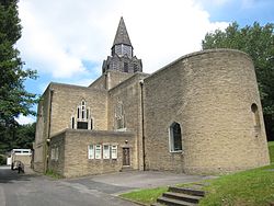
St Wilfrid's Church, Halton, Leeds
St Wilfrid's Church, Halton was designed by Albert Randall Wells and built between 1937 and 1939. It is situated in the 1930s suburb of Halton in Leeds, England.
The site on Halton Hill was given by Viscount Halifax and the building was paid for by Sir John Priestman. The foundation stone was laid on 6 November 1937. The church is Grade II* listed. It bridges the gap between the Arts and Crafts style and modernism. It has Early English gothic inspired details, such as the triangular-headed windows. The concrete vaulting within the interior in Nikolaus Pevsner's words "remind one of German Expressionism in recent church architecture rather than that of England".
The church was built at a cost of £11,700. It still has many of the original fittings designed by Wells as well as contemporary art by Eric Gill. Congregational seating was made by Edward Gardiner who, earlier, had a partnership with Ernest Gimson.

Distington
Distington () is a large village and civil parish in Cumbria, England, 3 miles (4.8 km) south of Workington and 4 miles (6.4 km) north of Whitehaven. Historically a part of Cumberland, the civil parish includes the nearby settlements of Common End, Gilgarran and Pica. The parish had a population of 2,247 in the 2001 census, increasing slightly to 2,256 at the 2011 census.
South of the village by the Lowca Beck are the fragmentary remains of Hayes Castle, a manor house fortified by Robert de Leyburn in 1322.

Pemberton, Greater Manchester
Pemberton is an area of Wigan, in Greater Manchester, England. It lies on the southwestern bank of the River Douglas, and east of the M6 motorway. The area is contiguous with Orrell and as a ward has a population of 13,638, increasing to 13,982 at the 2011 Census.
Historically a part of Lancashire, Pemberton was formerly a township and parish in the hundred of West Derby. Following the Industrial Revolution, Pemberton became a densely populated industrial district comprising a variety of coal mines, stone-quarries, brick manufactories, and cotton mills. Coal mining was the principal industry of what was described in 1911 as an "unpicturesque, bare and open" area. The former Pemberton Urban District, along with Wigan Municipal Borough merged to form the County Borough of Wigan in 1904.

A721 road
The A721 road in Scotland runs mainly through North Lanarkshire and South Lanarkshire, serving as a main route within Bellshill, Motherwell, Wishaw and Carluke. It falls within the boundaries of Glasgow and the Scottish Borders for short distances at either end.

Kirkconnel
Kirkconnel (Gaelic: Cille Chonbhaill) is a small parish in Dumfries and Galloway, southwestern Scotland. It is located on the A76 near the head of Nithsdale. Principally it was a mining community thriving until the late 1960s when the local mine, Fauldhead colliery closed. It has strong ties to football. The name comes from The Church of Saint Conal. In 1850 the village had only a single street. Next to Kirkconnel is a separate village called Kelloholm.
It is also associated with the ballad Helen of Kirkconnel.

Pollokshields East
Pollokshields East was a police burgh in Scotland that had a brief independent existence in the 19th century. The burgh was created within the Govan parish in the county of Renfrewshire in 1880. Bartholomew's Gazetteer of the British Isles (1887) states that Pollokshields East had a population of 4,360. Along with the neighbouring burgh of Pollokshields, it was officially absorbed into the city of Glasgow in 1891, the two burghs being induced to agree by the promise of taxation concessions. Unlike its neighbour, where development was restricted by feu to residential villas, Pollokshields East was a more working class area with commercial and industrial developments, although the tenements in the district were among the best-appointed in the city. Land use in modern Pollokshields still reflects the different histories of the two former burghs.

Harrogate
Harrogate ( HARR-ə-gət, -gayt, -ghit) is a spa town and civil parish in the district and county of North Yorkshire, England. Historically in the West Riding of Yorkshire, the town is a tourist destination; its visitor attractions include its spa waters and RHS Harlow Carr gardens. Yorkshire Dales National Park and the Nidderdale AONB are 13 miles (21 km) away from the town centre.
In the 17th century, Harrogate grew out of two smaller settlements, High Harrogate and Low Harrogate. For three consecutive years (2013–2015), polls voted the town as "the happiest place to live" in Britain. Harrogate spa water contains iron, sulphur, and common salt (NaCl). The town became known as 'The English Spa' in the Georgian era, after its waters were discovered in the 16th century. In the 17th and 18th centuries its 'chalybeate' waters (containing iron) were a popular health treatment, and the influx of wealthy but sickly visitors contributed significantly to the wealth of the town.
Harrogate railway station and Harrogate bus station in the town centre provide transport connections. Leeds Bradford Airport is 10 miles (16 km) southwest of Harrogate. The main roads through the town are the A61, connecting Harrogate to Leeds and Ripon, and the A59, connecting the town to York and Skipton. Harrogate is also connected to Wetherby and the A1(M) by the A661, while the A658 from Bradford forms a bypass around the south of the town. Harrogate had a population of 73,576 at the 2011 UK census; the built-up area comprising Harrogate and nearby Knaresborough had a population of 89,060, while the figure for the much wider Borough of Harrogate, comprising Harrogate, Knaresborough, Ripon, as well as a number of smaller settlements and a large rural area, was 157,869.
The town motto is Arx celebris fontibus, which means "a citadel famous for its springs".

Kirn & Sandbank Parish Church
Kirn & Sandbank Parish Church is a Church of Scotland church building in Kirn, Argyll and Bute, Scotland. It also serves the population of nearby Sandbank. The church is located on Kirn Brae at its junction with Marine Parade, which leads to and from Dunoon, about a mile to the southwest. Constructed in the Romanesque style, it is a Category B listed building.
Its architect was Peter MacGregor Chalmers. Its red sandstone was brought from a quarry at Corrie on the Isle of Arran.

Chapel-en-le-Frith Town Hall
Chapel-en-le-Frith Town Hall is a municipal building in Market Street, Chapel-en-le-Frith, Derbyshire, England. The structure operates as a community events venue, as well as the offices and meeting place of Chapel-en-le-Frith Parish Council.

Jackton
Jackton is a suburban village lying on the western periphery of East Kilbride in South Lanarkshire, on the B764 Eaglesham Road connecting it to the village of Eaglesham. It is also adjacent to Thorntonhall, and the two villages share a newsletter, the Peel News, derived from the name of the road connecting the two. The settlement, as well as an area of surrounding farmland going as far as Lindsayfield was designated as a Community Growth Area for East Kilbride in South Lanarkshire's Local Development Plan 2. The development of new build housing, additional retail locations, and a new primary school are under construction as of July 2025. Jackton lies approximately 150 metres (490 ft) above sea level.
It is also the site of one of the two Scottish Training Centres for Police Scotland. The area is served by Thorntonhall railway station, which is around 1+1⁄2 miles (2.4 km) away, and Hairmyres railway station, which is around 1 mile (2 km) away.
The Gill Burn runs through the outskirts of the settlement. There is only one bus stop on each side of the road for the village. The only buses running through are the 395/396 run by Henderson Travel.
In 2019 it was approved to build a further 70 homes in the area, consisting of 4 and 5 bedroomed properties. Later, a large Community Growth Area was designated covering Jackton, surrounding the existing village. The development, creating a continuous built-up area over 1.5 square miles (3.9 km2) connecting with Lindsayfield, included a primary school and a new link road. A large roundabout was constructed.
In 2019, one of the streets in the area was the scene of gunfire, which caused a large police presence while it was investigated.
In 2020, Jackton distillery was founded near the village.
The area is represented by the local Jackton and Thorntonhall Community Council. The community lies on the very western edge of South Lanarkshire, near the border with East Renfrewshire, and is part of the UK Parliament constituency of East Kilbride, Strathaven and Lesmahagow, as well as the Scottish Parliament Constituency of East Kilbride.

Perth and Kinross
Perth and Kinross (Scots: Pairth an Kinross; Scottish Gaelic: Peairt agus Ceann Rois) is one of the 32 council areas of Scotland, and a lieutenancy area. It is bordered by Highland and Aberdeenshire to the north, Angus, Dundee, and Fife to the east, Clackmannanshire to the south, and Stirling and Argyll and Bute to the west.
Geographically the area is split by the Highland Boundary Fault into a more mountainous northern part and a flatter southern part. The northern area is a popular tourist spot, while agriculture makes an important contribution to the southern part of the area.
The area is run by Perth and Kinross Council, which is based in Perth.

Cumberland Coalfield
The Cumberland Coalfield is a coalfield in Cumbria, north-west England. It extends from Whitehaven in the south to Maryport and Aspatria in the north.