
 English
 Français
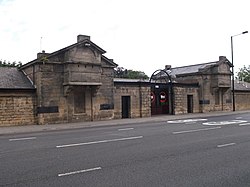
Fenham Barracks
Fenham Barracks is an Army Reserve installation on Barrack Road, Newcastle upon Tyne, Tyne and Wear, England.

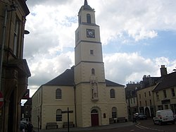
Old Town Hall and Market Hall, Darlington
The Old Town Hall and Market Hall is a municipal complex in West Row in Darlington, County Durham, England. The old town hall was the headquarters of Darlington Borough Council until it moved to the new town hall in Feethams in 1970. The complex consists of three separate buildings, all of which are Grade II listed: the old town hall, the market hall and the clock tower.

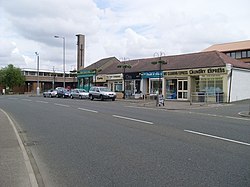
Johnstone railway station
Johnstone (Strathclyde) railway station serves the town of Johnstone, Renfrewshire, Scotland. The station is managed by ScotRail and is on the Ayrshire Coast Line 10+3⁄4 miles (17.3 km) south west of Glasgow Central. Johnstone has no ticket gates but ticket checks take place occasionally.

Bucklow Hundred
The hundred of Bucklow was an ancient division of the historic county of Cheshire, in northern England. It was known to have been in existence at least as early as 1260, and it was formed from the earlier Domesday hundreds of Bochelau and Tunendune.


All Saints' Church, East Cowton
All Saints' Church is an Anglican church in East Cowton, a village in North Yorkshire, in England.
A stone church, dedicated to Saint Mary, was built in East Cowton in the 14th century, and largely rebuilt in 1707. It had a nave, chancel, north vestry, south porch, and a small west tower built of brick. The church was some distance from the village centre, and by the early 20th century it was considered to be too small, and in need of major repair. Instead, it was abandoned, and a new church was completed in 1910, to the designs of John Woolfall and Thomas Eccles. By 1966, the old church was described as "a rotting barn-like building with a square brick tower", and it was demolished in 1968. The new building was grade II listed in 1998, and it was extended in 2002.
The church is built of red brick with stone dressings and tile roofs. It consists of a continuous nave and chancel, a south porch, and a north vestry. On the roof, at the division between the nave and the chancel, is a hexagonal shingled flèche, with a louvred bell stage and an iron weathervane. Inside is a 12th-century font brought from the old church.

Gipton
Gipton is a suburb of east Leeds, West Yorkshire, England, between the A58 to the north and the A64 to the south.
It is in the Gipton and Harehills ward of Leeds City Council and the Leeds East parliamentary constituency. The separate area and woodland of Gipton Wood is in Oakwood, north of Harehills and part of the Roundhay ward. Gipton’s residents are known as Giptonites.
Stamperland
Stamperland is a suburban neighbourhood in Clarkston, East Renfrewshire, Scotland. Part of the Greater Glasgow conurbation, it is situated on the west bank of the White Cart Water about 4.5 miles (7.2 km) south of Glasgow city centre, and just outside the city boundary.

Peebles Old Parish Church
The Old Parish Church of Peebles is one of several Christian churches in Peebles, Borders, Scotland. It is a congregation of the Church of Scotland. Dedicated on 29 March 1887, it lies at the end of the High Street.
The church was constructed between 1885 and 1887 at a cost of £9,500. It includes some features from an earlier parish church built on the site in 1784. The architect was William Young of London who designed the church in a Gothic style.
The church is a member of Peebles Churches Together.

Ancroft
Ancroft is a village and civil parish (which includes the village of Scremerston) in Northumberland, England. Prior to 1844, Ancroft lay within the Islandshire exclave of County Durham. It is south of Berwick-upon-Tweed, and has a population of 885, rising slightly to 895 at the 2011 census.
There are several suggestions as to how Ancroft got its name. It might be an abridged version of "Aidan's-croft" - the croft of St Aidan who was the first Bishop of Lindisfarne (Holy Island). Alternatively, it might be that as the church is dedicated to Saint Anne, the village took its name from the church - "St Anne's croft". A third suggestion is simply that it means one croft or solitary croft - "ane croft".
There was surely more than one croft here when the church was built, probably towards the end of the 11th century; but in common with most of this region, the community declined in the latter part of the 13th century because of the continual border raids by the Scots. This turbulent history is reflected in the number of castles and peel towers in the vicinity, besides the fortified tower that was added to the church in the thirteenth century.
Because of the repeated incursions by Scots, this northern part of what we now call Northumberland was placed in the charge of the prince-bishops of Durham. They were powerful and wealthy men who had the resources to defend the border. That is why this area was still part of County Durham until the mid 1800s.
After the accession of James I (James VI of Scotland) to the throne of England in 1603 there seems to have been a return of people to the village. But in 1667 the plague struck Ancroft, The victims were carried out into the fields where they were covered with shelters made from branches of broom. After death both bodies and shelters were burned in a rudimentary and fruitless attempt to control the spread of the disease. To this day a field to the south of the village is called "Broomie Huts". In desperation the authorities of the day ordered that the plague-affected cottages should be burned to the ground. The mounds where the cottages stood, and the former village street, can still be seen in the field between the main road and the burn.
By the time of Queen Anne (1702–1714) the village was flourishing once more, with a population of over one thousand. The main industry, other than farming, was shoe and clog making. Sailors of the Royal Navy wore shoes or slippers from Ancroft. The naval specification required footwear with no metal parts - an obvious precaution to avoid sparks in a wooden ship loaded with gunpowder and tarred rope! Boots were also made for the British army - the Duke of Marlborough's troops marched to victory shod in Ancroft boots. A village tradition claims that each of the one hundred trees on the southern skyline represents a cobbler.
Several of the local settlements originated around coal mines, an industry which is being redeveloped in today's open cast sites.

Kingston Halls
Kingston Halls is a municipal structure in Paisley Road in the Kingston area of Glasgow, Scotland. The structure, which is used as the headquarters of a charity which provides accommodation and support to homeless people, is a Category B listed building.

Huntington, North Yorkshire
Huntington is a village and civil parish in the unitary authority of City of York in North Yorkshire, England. It is part of the Huntington & New Earswick ward and lies on the River Foss, to the north of York and the south of Strensall.
The village was historically part of the North Riding of Yorkshire until 1974. It was then a part of the district of Ryedale in North Yorkshire from 1974 until 1996. Since 1996 it has been part of the City of York unitary authority.
According to the 2001 census Huntington had a population of 9,277, increasing to 12,108 at the 2011 census.
Huntington is made up of mainly low-lying land, with the highest point in the village being only 64 feet above sea level. It covers some 4,800 acres (19 km2) and measures some 4 miles (6 km) from north to south and 3 miles (5 km) east to west.

Newton Heath railway station
Newton Heath Railway Station served the district of Newton Heath in east Manchester. It was opened by the Lancashire and Yorkshire Railway (LYR) on 1 December 1853 and was closed by British Railways on 3 January 1966.
The station buildings were situated on the northwest side of Dean Lane, where that road passed over the LYR line from Manchester Victoria to Rochdale, and 300 yards north of Dean Lane. It was immediately adjacent to the large LYR Newton Heath steam locomotive shed. The Railway Hotel remains in operation at the former station site.
The area is now served by Newton Heath and Moston tram stop, which opened on 13 June 2012.

Ovingham
Ovingham is a village and civil parish in the Tyne Valley of south Northumberland, England. It lies on the River Tyne 10 miles (16 km) east of Hexham with neighbours Prudhoe, Ovington, Wylam and Stocksfield.
The River Tyne provided an obstacle between Ovingham and Prudhoe until 20 December 1883, when a toll bridge (Ovingham Bridge) was finally opened, taking the place of the ferry. The steel tubes are marked Dorman Long Middlesbrough, the firm which designed and built the Sydney Harbour Bridge and the Tyne Bridge.

Redcar Mudstone Formation
The Redcar Mudstone Formation is a geological formation in North Yorkshire, England. Part of the Lias Group, it was deposited in the Hettangian to Pliensbachian stages of the Early Jurassic. The lithology consists of fissile mudstones and siltstones, with the lower part having thin beds of limestone and the upper part having thin beds of sandstone. The Redcar Mudstone Formation at Wine Haven, Robin Hood's Bay, Yorkshire contains the Global Boundary Stratotype Section and Point (GSSP) for the base of the Pliensbachian.

Trinity Presbyterian Church (San Francisco)
Trinity Presbyterian Church, known from 1972 on as Mission United Presbyterian Church, is a historic Presbyterian church at 3261 23rd Street in the Mission District of San Francisco, California.
It was built in 1891 and added to the National Register of Historic Places in 1982.
It is one of relatively few works by architects Percy & Hamilton which survived the 1906 earthquake.

Saltaire United Reformed Church
Saltaire United Reformed Church (originally Saltaire Congregational Church) is a church at Saltaire, West Yorkshire, England. Commissioned and paid for by Titus Salt in the mid 19th century, the church is a Grade I listed building and sits within the Saltaire World Heritage Site.

St Nicholas Parish Church, Lanark
St Nicholas Parish Church is a category B listed building and Church of Scotland place of worship in the town centre of Lanark, South Lanarkshire, Scotland.
The original 13th-century chapel was documented as early as 1890, however at that time it was claimed that there were no remnants of that building. A survey in the 1990s conducted by the Lanark and District Archaeological Society was able to find artefacts dating back to the 13th century, as well as 16th century pillars believed to have been constructed by Thomas Twaddle in 1571. Sources also reported evidence of the chapel's continued use in the medieval period and post-Reformation.
Over the front entrance is an eight-foot-tall (approximately 2.4 meters) statue of William Wallace. This dates back to the early 19th century and was sculpted by Robert Forrest.
In 2004, the remains of a well were found on the former grounds of the church during a routine ground breaking. There is documentation of the well's existence dating back to 1662; it was found in what is now Bloomgate, close to the church building, and was filled in after being drained and recorded.
The church has had many ministers over the years, but has been left without a resident minister since 30 November 2014, when the incumbent Rev Alison Meikle left for Grangemouth Zetland.

Cod Beck Reservoir
Cod Beck Reservoir is a man-made lake situated within the North York Moors National Park, near the village of Osmotherley in the English county of North Yorkshire. The reservoir is named after Cod Beck, which is the small river that fills it.