
 English
 Français

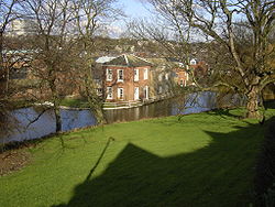
Fulwood Hall
Fulwood Hall, (archaic: Fullwood Hall) is an English country house situated on Harrison Lane in the suburb of Fulwood in Sheffield, England. It is a Grade II listed building. The hall stands in a lofty position on the north side of the Mayfield Valley at a height of 270 metres (885 feet). The hall is referred to as Fullwood Hall on old maps and the gate to the hall uses this spelling with two Ls.
Nearby Places View Menu

881 m
Fulwood Old Chapel
Fulwood Old Chapel is a Unitarian place of worship in the Fulwood district of western Sheffield, South Yorkshire. It is a member of the General Assembly of Unitarian and Free Christian Churches, the umbrella organisation for British Unitarians.
The chapel was built from 1728 to 1729 as a meeting house for English Dissenters, who had previously met under John Fox at Fullwood Hall. William Ronksley left £400 in his will for the construction of a "large and handsome" chapel, although the construction itself cost only £75. The chapel is the second-oldest religious building in south or west Sheffield, after Beauchief Abbey.
The single-storey building is constructed of coursed stone and dressed with ashlar, and has stone slate roofs. The walls are around two feet thick. The street frontage has four mullioned windows, doors being placed between the first and second, and third and fourth, windows. A tablet above the two central windows reads "Built 1729 in pursuance of the last Will of Mr W Roncksley".
In 1754, a school room was added; this was extended in 1968 to include a kitchen and toilets, and was again modernised in 2009. It is currently used for a Sunday school and social events. Other changes were made in 1959, when a small storm porch was added inside the main entrance.
The chapel is now Grade II listed. A garden formerly laid outside the chapel, but this was removed in 1929, when the road was widened. At the same time, the early nineteenth century village stocks were then moved to lie in front of the building, and these are now also Grade II listed.
Samuel Plimsoll is believed to have worshipped at the chapel in the 1860s, and his first daughter may be buried under its floor.

1.0 km
Crimicar Lane Hospital
Crimicar Lane Hospital and Sanatorium was an isolation hospital for sufferers of smallpox and tuberculosis in the City of Sheffield, England. It was situated in the suburb of Lodge Moor. The hospital opened in 1902 and closed in 1956.
1.0 km
Porter Brook
The Porter Brook is a river which flows through the City of Sheffield, England, descending over 1,000 feet (300 m) from its source on Burbage Moor to the west of the city to its mouth where it joins the River Sheaf in a culvert beneath Sheffield railway station. Like the other rivers in Sheffield, its steep gradient made it ideal for powering water mills and works associated with the metalworking and cutlery industries, and around 20 dams were constructed over the centuries to facilitate this. At its lower end, it is extensively culverted, but parts of it are gradually being restored to open channels, as part of a daylighting scheme for the city.
The brook derives its name from its brownish colour, similar to the colour of Porter beer.

1.0 km
Porter Valley Parks
The Porter Valley Parks are a series of public parks and green spaces in Sheffield, England. Lying along the valley of Porter Brook, they run radially out from the city centre, providing a direct green-space connection to the Peak District national park. Created variously between 1855 and 1938, they comprise in order from the city centre; Endcliffe Park, Bingham Park, Whiteley Woods, Forge Dam Park and Porter Clough.
The parks are listed at Grade II on the Register of Historic Parks and Gardens. The Friends of the Porter Valley is a registered charity which supports their maintenance and improvement.
National Cycle Route 6 passes through parts of Bingham Park, Whiteley Woods and Porter Clough.