
 English
 Français

Gardham
Gardham or Low Gardham is a small hamlet in the East Riding of Yorkshire, England. It is situated approximately 5 miles (8 km) west of Beverley town centre and 2 miles (3.2 km) west of the village of Cherry Burton. 1.5 miles (2.4 km) to the north-east lies Etton.
Gardham forms part of the civil parish of Cherry Burton.

New Ridley
New Ridley is a hamlet in the county of Northumberland, England. It is in the parish of Stocksfield and the parliamentary constituency of Hexham. It is one of four "Ridleys" in the parish, along with Old Ridley, East Ridley and Ridley Mill.
Services in New Ridley include Stocksfield Golf Club and the Dr. Syntax public house. The pub is named after a racehorse of the same name which was in turn named after a fictional character created by the writer William Combe.

York Art Gallery
York Art Gallery is a public art gallery in York, England, with a collection of paintings from 14th-century to contemporary, prints, watercolours, drawings, and ceramics. It closed for major redevelopment in 2013, reopening in summer of 2015. The building is a Grade II listed building and is managed by York Museums Trust.

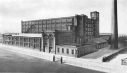
Manchester City Police Headquarters
The Manchester City Police Headquarters historic building is located in Manchester, England. It was built during 1933–37 as the headquarters of the Manchester City Police.

St Mary's Church, Norton
St Mary's Church, Norton, is an ancient parish church located on the village green of Norton, County Durham. It is the only cruciform Anglo-Saxon church in northern England and a Grade I listed building.

Cornton
Cornton, known locally as The Cornton, is a district of the city of Stirling on the North Bank of the River Forth in central Scotland.

Skirpenbeck
Skirpenbeck is a village and civil parish in the East Riding of Yorkshire, England. It is situated 2 miles (3.2 km) north-west of Stamford Bridge just north of the A166 road.
According to the 2011 UK census, Skirpenbeck parish had a population of 192, an increase on the 2001 UK census figure of 142. In 2019 this was estimated to be 304.
The place-name 'Skirpenbeck' is first attested in the Domesday Book of 1086, where it appears as Scarpenbec. It derives from the Old Norse skerping and bekkr, meaning barren land by a beck or stream.
Skirpenbeck is near Stamford Bridge, over the River Derwent, near where King Harold of England defeated Harald Hardrada King of Norway in 1066. Its first baron was Sir William de Chauncy, son of Chauncy de Chauncy.
Unusually for a village there are a still number of working farms in the village, some of which have been farmed by the same families for generations. There are currently 7 working farms in the village.
The parish church of St Mary's is a Grade II* listed building.
There are markings on the church building (near the bell tower) that appear to be Saxon runes.
The village has also had some notable residents:
Alick Walker the palaeontologist was born in Skirpenbeck.
Thomas Cooke the machinist was the school Headmaster in Skirpenbeck where he also created precision scientific instruments such as microscopes and telescopes.
Frederick James Lloyd, more commonly known as James Lloyd, was an English artist. He became famous for his paintings, mostly of animals and country landscapes. He was the first living self-taught artist to have a painting hung at the Tate in London, titled Cat and Mouse. He and his family moved to Skirpenbeck in 1950 where he took on the job as a cowman. There were now so many paintings, laboriously constructed dot by dot (pointillism). His wife Nancy decided it was time that Lloyd's work was seen by more people. Without telling her husband she wrote to Sir Herbert Read and he paid Lloyd a visit to see his paintings, and bought a couple of them. Herbert Read sent some to various galleries in London.
In 1958 Lloyd held his first one-man show at (the late) Arthur Jeffress Gallery in London. All but 2 of the 32 paintings being held were sold within hours of opening.
East Durham College Technical Academy
East Durham College Technical Academy is a construction training college in the North East of England. The College provides training for people who wanted to work in the construction industry, as well as providing additional skills development for people already working in the industry.
Students of all ages can enrol on a range of full-time and part-time courses.

Ace Mill, Hollinwood
Ace Mill is a cotton spinning mill in Chadderton in the Metropolitan Borough of Oldham, Greater Manchester. It was built as Gorse No. 2 Mill, in 1914 and cotton was first spun in 1919 by the Ace Mill Ltd, who renamed the mill. It was taken over by the Lancashire Cotton Corporation in the 1930s and passed to Courtaulds in 1964. Production ended in 1967.
Although known as Ace Mill, Hollinwood (due to Hollinwood being the closest serving railway station), the mill is located in the Whitegate area of south Chadderton around a mile away from Hollinwood.
The five-storey mill has a floor area of 38,500 sq ft (3,580 m2). It is now used as a warehouse. It was powered by a 2500 hp cross compound engine (Mary and Elizabeth) by Urmson and Thompson built in 1920. It had a 26 ft (7.9 m) flywheel with 42 ropes that ran at 64rpm.

RAF Bridlington
Royal Air Force Bridlington, or more simply RAF Bridlington, was a Royal Air Force station located in Bridlington, East Riding of Yorkshire, England, between 1929 and 1978. Several units operated at Bridlington, Air Gunnery Schools, Initial Training Wings, and an Air Sea Rescue launch unit, but the longest occupier, was No. 1104 Marine Craft Unit (MCU). The station consisted of various buildings across the town that were requisitioned for RAF use before and during the Second World War. Outside of this time, the RAF presence was mostly in the harbour area and as it was such a small unit, No. 1104 MCU was looked after (parented in Air Force parlance) by other RAF Stations nearby.
It is known that under his official Air Force title of Aircraftsman Second Class T. E. Shaw, the archaeologist, (former) army officer, diplomat, and writer, T. E. Lawrence worked at RAF Bridlington during the 1930s.

Saint Stephen's Theatre, Edinburgh
Saint Stephen's Theatre is a former Church of Scotland church located in the Northern New Town of Edinburgh, Scotland, at the corner of Saint Stephen Street and Saint Vincent Street, now a theatre and event venue.

Black Brook (Chorley)
Black Brook in Lancashire has its source at Great Hill in the West Pennine Moors. The water is acidic due to a high level of peat in the uplands near to Round Loaf, giving the brook its brown colour. The young river was known as Warth Brook in olden Heapey. A feeder stream also known as Black Brook joins near Kittiwake Road - this short and weak water course commences at Eagle Tower. The jointed brook feeds Anglezarke Reservoir, and joins the River Yarrow in lowland Chorley at Yarrow Bridge. The entire course of Black Brook and the River Yarrow fall within Chorley and its villages.

Inveralmond Roundabout
Inveralmond Roundabout is a major traffic roundabout in Perth, Scotland. Located approximately 2 miles (3.2 km) north-northwest of the city centre, it is the meeting point of the A912 Dunkeld Road (at the northern terminus of its route to and from the city centre) and the more prominent A9 road, which changes between being east–west running to north–south, picking up its historic route after skirting the city via a bypass. It is one of Perth's two major roundabouts, the other being at Broxden Junction, where the A9 merges with the M90, 2.3 miles (3.7 km) to the south-southwest.
The roundabout is so named due to its proximity to the River Almond, which flows under the A9 around 1,300 feet (430 yd) to the north, approximately 0.3 miles (0.48 km) west of its confluence with the River Tay.
Inveralmond Industrial Estate is located adjacent to the roundabout to the northwest, accessed by the Ruthvenfield Road exit.
The Cross Tay Link Road is under construction as of July 2022. When completed it will link the section of the A9 immediately north of the roundabout with the A93 and A94 near Scone, to the east.

Wombwell railway station
Wombwell railway station is a railway station serving the town of Wombwell in South Yorkshire, England. The station is 12 miles (19 km) north of Sheffield on the Hallam and Penistone Lines. The station was opened by the Midland Railway on 1 July 1897, and between 25 September 1950 and 20 February 1969 was known as Wombwell West to distinguish it from Wombwell's other railway station, Wombwell Central, which closed in 1959.
CCTV was recently installed for the purposes of crime prevention. Other recent improvements to the station include new signage, lighting, and, for the first time, installation of passenger information display screens to provide real-time service information.
The station car park was extended in 2009 to give a total of 74 spaces for rail users.

Haydon Bridge
Haydon Bridge is a village in Northumberland, England, which had a population of 2,184 in the 2011 census. Its most distinctive features are the two bridges crossing the River South Tyne: the picturesque original bridge after which the village was named (now restricted to pedestrian use) and a modern bridge which used to carry the A69 road. A bypass was completed in 2009 and the A69 now bypasses the village to the south.
The modern village is divided in two by the River South Tyne, whereas the old village (Haydon) was to the north, on the hill overlooking the river; all that remains is a Norman church now reduced in size from the original, which used stone taken from nearby Roman Hadrian's Wall. The A686 road joins the A69 just to the south east of the village, linking Haydon Bridge with Alston and Penrith.

Culcheth and Glazebury
Culcheth and Glazebury is a civil parish in Borough of Warrington, Cheshire, England. At the 2001 census, it had a population of 8,534.

Ulverston Canal
The Ulverston Canal is a 1.25-mile (2 km) ship canal that connects the town of Ulverston, Cumbria, England with Morecambe Bay. The waterway, which is entirely straight and on a single level, is isolated from the rest of the UK canal network. It was built so that maritime trading vessels could use the town's port.
Ulverston Canal was built in the late 18th century. Wharves were built in the town to handle the cargo and goods being loaded and unloaded from seagoing vessels. The canal promoted the industrial development of Ulverston. Despite its loss of economic importance with the construction of the Furness Railway in the mid 19th century, the canal remained in commercial operation until the 1940s when it was eventually abandoned. The canal's preservation is now managed by a property management company that receives funding from GlaxoSmithKline, which has a plant adjacent to the canal.
The canal runs between its former sea entrance, known as Canal Foot, at Hammerside Point on Morecambe Bay and its basin and wharves at Ulverston. The 112-foot-long (34 m) sea lock was the only lock on the canal; however, the lock has been sealed with a concrete dam and footbridge. Beside the canal is a sheep and cattle auction and several waterside buildings have been renovated. At its mouth, the Bay Horse Hotel stands on the site of an 18th-century coaching inn; the Cumbria Coastal Way crosses the canal at this point.

Melmerby, Harrogate
Melmerby is a village and civil parish in North Yorkshire, England, that lies 3.7 miles (6 km) north of Ripon and 0.6 miles (1 km) west of the A1(M) motorway. The population was 386 in the 2011 census.

New Coundon
New Coundon is a small village in County Durham, in England. It is situated to the west of Coundon, near Bishop Auckland. In the 2001 census New Coundon had a population of 41.