
 English
 Français

Sergeant's Crag
Sergeant's Crag is a fell in the English Lake District. It is an intermediate height on the ridge between the Langstrath and Greenup valleys in the Central Fells.

St John the Baptist's Church, Leeming
St John the Baptist's Church is an Anglican church in Leeming, North Yorkshire, a village in England.
A chapel was first constructed in Leeming in 1424, with a bequest from a traveller who had fallen ill in the village. It survived the English Reformation by becoming a chapel of ease to St Lambert's Church, Burneston, but was ruined by 1838. In 1839, a new church was constructed on the same site, to a design by Ignatius Bonomi. A tower was added in 1910, and the building was grade II listed in 1986.
The church is built of red brick with stone dressings and a tile roof. It consists of a nave, a chancel with a north vestry, and a west tower. The tower has three stages, diagonal buttresses, a doorway with a pointed arch, a chamfered surround and a hood mould, two-light bell openings, and an embattled parapet with corner pinnacles.
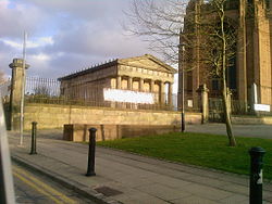
The Oratory, Liverpool
The Oratory stands to the north of Liverpool Anglican Cathedral in Merseyside, England. It was originally the mortuary chapel to St James Cemetery, and houses a collection of 19th-century sculpture and important funeral monuments as part of the Walker Art Gallery. It is a Grade I listed building in the National Heritage List for England.

Rostherne
Rostherne is a village and former civil parish, now in the parish of Millington and Rostherne, in the unitary authority area of Cheshire East and the ceremonial county of Cheshire, England (grid reference SJ743835). In 2001 the parish had a population of 160.
To the north of the village is Rostherne Mere and to the south is Tatton Park. The A556 road passes to its west.
Boxhead Pot
Boxhead Pot is a cave on Leck Fell, in Lancashire, England. It leads into the top end of Lost Johns' Cave, and is part of the Three Counties System, an 87 kilometres (54 mi) cave system which spans the borders of Cumbria, Lancashire, and North Yorkshire.

Bulnes (Buenos Aires Underground)
Bulnes is a station on the Line D of the Buenos Aires Underground at the intersection of Avenida Santa Fe and Bulnes Street. The station was opened on 23 February 1940 as part of the extension of Line D from Tribunales to Palermo.

Hadrian's Wall
Hadrian's Wall (Latin: Vallum Hadriani; also known as the Roman Wall, Picts' Wall, or Vallum Aelium in Latin) is a former defensive fortification of the Roman province of Britannia, begun in AD 122 in the reign of the Emperor Hadrian. Running from Wallsend on the River Tyne in the east to Bowness-on-Solway in the west of what is now northern England, it was a stone wall with large ditches in front and behind, stretching across the whole width of the island. Soldiers were garrisoned along the line of the wall in large forts, smaller milecastles, and intervening turrets. In addition to the wall's defensive military role, its gates may have been customs posts.
Hadrian's Wall Path generally runs close along the wall. Almost all the standing masonry of the wall was removed in early modern times and used for local roads and farmhouses. None of it stands to its original height, but modern work has exposed much of the footings, and some segments display a few courses of modern masonry reconstruction. Many of the excavated forts on or near the wall are open to the public, and various nearby museums present its history. The largest Roman archaeological feature in Britain, it runs a total of 73 miles (117.5 kilometres). Regarded as a British cultural icon, Hadrian's Wall is one of Britain's major ancient tourist attractions. It was designated a UNESCO World Heritage Site in 1987. The turf-built Antonine Wall of AD 142 in what is now central Scotland, which briefly superseded Hadrian's Wall before being abandoned, was declared a World Heritage Site in 2008.
Hadrian's Wall lies entirely within England and has never formed the Anglo-Scottish border, though it is sometimes loosely or colloquially described as such.

Humber Gap
The Humber Gap is a term for the geographic gap between the roughly north–south running line of hills formed by the Yorkshire Wolds and the Lincolnshire Wolds, formed by the west–east running Humber Estuary.
In the geological past the gap has formed part of an ice barrier due to glaciers during the ice age resulting in damming and formation of a 'Humber Lake', and also forms a geological division.
In modern times the gap has formed a natural choice for transport routes, such as the railways. The Humber Bridge also crosses the Humber close to the gap.

A930 road
The A930 is a single carriageway road in Angus, Scotland. It runs from Dundee to Carnoustie.
Starting at its junction with the A92 road in Craigie, Dundee, it runs east through West Ferry, Broughty Ferry, Barnhill and Monifieth. It then passes through countryside north of the Buddon Ness, past Barry (through which it passed until 2003 on the construction of the bypass), to Carnoustie. It forms the main thoroughfare in Carnoustie and turns north at the eastern end of the town, heading north towards Muirdrum. The road is a single carriageway along its entire length.

BBC Radio Cumbria
BBC Radio Cumbria is the BBC's local radio station serving the county of Cumbria.
It broadcasts on FM, AM, DAB, digital TV and via BBC Sounds from studios in Carlisle.
According to RAJAR, the station has a weekly audience of 80,000 listeners and a 8.4% share as of May 2025.

Lennox Tower
Lennox Tower is a ruinous fifteenth-century tower house at Lymphoy, near the Water of Leith, between Balerno and Currie, 11 kilometres (6.8 mi) south-west of Edinburgh, Scotland.

Red Burn
The Red Burn is one of two main streams which flow out of Cumbernauld. The Scottish New Town’s name derives from the Gaelic for "the meeting of the waters" and there is broad agreement that one of these waters is the Red Burn.

Leeds Girls' High School
Leeds Girls' High School (LGHS) was an independent, selective, fee-paying school for girls aged 3–18 founded in 1876 in Headingley, Leeds, West Yorkshire, England. It merged with Leeds Grammar School in 2008 to form The Grammar School at Leeds.
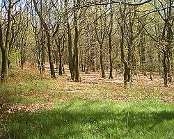
Bowden Housteads Woods
Bowden Housteads Woods are situated between Darnall and Handsworth, Sheffield, South Yorkshire, England. The woods are encircled by Sheffield Outer Ring Road, Sheffield Parkway and Handsworth Road and are classified as ancient woodlands, having been in existence since the 17th century. The Car Brook flows through the wooded area. Spring brings a carpet of bluebells. The woods are a Local Nature Reserve.
Royal Armouries Museum
The Royal Armouries Museum in Leeds, West Yorkshire, England, is a national museum that holds the National Collection of Arms and Armour. It is part of the Royal Armouries family of museums, with other sites at the Royal Armouries' traditional home in the Tower of London, and the National Collection of Artillery at Fort Nelson, Hampshire. The Royal Armouries is a non-departmental public body sponsored by the Department for Culture, Media and Sport.
The Royal Armouries Museum is a £42.5 million purpose-built museum located in Leeds Dock that opened in 1996. Its collection was previously on display or in storage at the Tower of London where the Royal Armouries still maintains a presence and displays in the White Tower.
As at all UK National Museums, entry is free, though certain extra attractions are charged for.
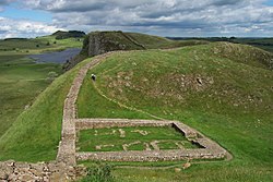
Crag Lough
Crag Lough is an inland lake at the southern edge of Northumberland National Park, 2.5 miles (4.0 km) north of Bardon Mill, and 0.5 miles (0.8 km) north of the B6318 Military Road in Northumberland, northern England. At this point Hadrian's Wall is at the top of a line of crags, the Whin Sill, with Crag Lough at the foot of the crags.

Glusburn
Glusburn is a village and electoral ward in the county of North Yorkshire, England. The village is situated on the edge of the Yorkshire Dales, sits on the A6068 Kildwick to Hapton road, and is conjoined to the village of Sutton-in-Craven at the south.
The village is the older part of the civil parish of Glusburn and Cross Hills, historically known as Glusburn. The newer part of the parish is known as Cross Hills. The parish had a population of 3,902, increasing to 3,980 at the 2011 Census.
Until 1974 it was part of the West Riding of Yorkshire. From 1974 to 2023 it was part of the district of Craven, it is now administered by the unitary North Yorkshire Council.

Blelham Tarn
Blelham Tarn is a large valley tarn in the Lake District of England, to the north of the hill Latterbarrow. The settlements of Outgate, Low Wray and High Wray are close by. The tarn is drained to the northeast by the short Blelham Beck into Windermere. This beck was previously straightened and lowered.
Fish species in the tarn include brown trout, eel, perch, pike and roach, much of the tarn shore is reedbed and waterfowl present can include great crested grebe, whooper swan and golden-eye.
The tarn is regularly monitored by the United Kingdom Lake Ecological Observatory Network and is characterised as eutrophic and monomictic and has suffered from agricultural water pollution with large quantities of blue-green algae in the summer. The lake temperature at various depths varied over the period July 2012 to November 2014 between 2 and 25 Celsius as the air temperature (3 m above the surface) varied between -3 and 22 Celsius. Over the same period the pH varied from 6.4 to 9.8 and the
dissolved oxygen ranged from 7 to 14 mg/L.
Blelham Tarn and Bog, with a total area of 49 hectares, is designated a site of special scientific interest and Blelham Bog is designated a National Nature Reserve The bog contains various species of sphagnum moss, bog myrtle, cotton-grass and the white-beaked sedge; and rare caddis-flies and vertigo lilljeborgi.
MetroCentre
Metrocentre (previously styled as MetroCentre) is a shopping centre and entertainment complex in the Dunston area of Gateshead. It is located on the former site of Dunston Power Station, near to the River Tyne.
Metrocentre opened in stages, with the first phase opening on 28 April 1986, and the official opening being held on 14 October that year. It has 210 shops, 63 restaurants, an Odeon cinema, a Clip n’ Climb, a bowling alley, a Namco Funscape, The Escapologist and Treetop Golf, occupying over 2,000,000 sq ft (190,000 m2) of retail floor space, making it one of the largest shopping centres in the UK. Additional retail space can be found in the adjoining Metro Retail Park and MetrOasis.

Bainton, East Riding of Yorkshire
Bainton is a village and civil parish in the East Riding of Yorkshire, England. It is situated approximately 6 miles (10 km) south-west of Driffield on the A614 road.
According to the 2011 UK census, Bainton parish had a population of 334, an increase on the 2001 UK census figure of 282. The parish covers an area of 1,608.08 hectares (3,973.7 acres).
The name Bainton derives from the Old English beagaingtūn meaning 'settlement connected with Beaga'.
Bainton was served by Bainton railway station on the Selby to Driffield Line between 1890 and 1954.
Bainton Grade I listed Anglican church is dedicated to St Andrew. Pevsner noted that the church was totally rebuilt in the 1330s or 1340s by the rector William de Brocklesby, except for the south-west corner of the chancel with its priest's doorway, which are c. 1300. Until 1715 the tower supported a spire. The font is Norman, and the pews 18th century. A tomb to Sir Edmund de Mauley lies in the south aisle; [de Mauley, Steward to Edward II, died at the Battle of Bannockburn in 1314]. The tomb has an ogee canopy, crocketed gable and flying angels holding the soul of Sir Edmund in a napkin. There is also a brass to Roger Godeale, died 1429. A south porch and vestry were added by Henry Wheatley in 1843, and a restoration carried out by "Fowler of Louth" in 1866. The church's listed rectory, south of the church, is of late Georgian period. According to Pevsner a local tradition connects the rectory's coniferous garden with Paxton The rectory's coach house and stables are also listed buildings.