
 English
 Français

Macrobert Arts Centre
Macrobert Arts Centre is a multi-arts venue located on the main campus of the University of Stirling, Scotland. The Arts Centre offers a varied programme of events and experiences – cinema, comedy, dance, exhibitions, family, get involved, music, opera and theatre – catering for audiences from across Stirling, the Forth Valley and beyond. It was originally opened in 1971 as Scotland's first purpose-built arts centre, the brainchild of the university's first principal, Tom Cottrell FRSE, who wanted appreciation of the arts to be at the heart of the university's cultural ethos.
In October 2002 the Arts Centre re-opened following a period of refurbishment by Appleton Architects and Buro Happold.
Macrobert Arts Centre is a registered charity under Scottish law. It receives key funding from Creative Scotland and the University of Stirling, while raising 70% of its required funds through ticket sales and donations, grants and sponsorship.

Heworth, York
Heworth ( HYOO-əth) is part of the city of York in North Yorkshire, England, about 1 mile (1.6 km) north-east of the centre. No longer in general referred to as a village, "Heworth Village" is now the name of a specific road. The name "Heworth" is Anglo-Saxon and means a "high enclosure".

Fort Kinnaird
Fort Kinnaird is a large outdoor retail park in Newcraighall, located off the A1 in the south-east of Edinburgh, Scotland. Often known simply as "the Fort" to locals, it is currently the second largest retail park in the UK with 75 units occupied.

Scout Green
Scout Green is a hamlet and small area of farm land near the village of Tebay in Cumbria, England.

Chickenley
Chickenley is a suburban village in the Borough of Kirklees, West Yorkshire, England. It is part of Dewsbury after being originally a farming hamlet, half-way between Ossett and Dewsbury.
In 1356 it was variously called Chekynlay and Chikynlay.
The Chickenley name could derive from a family name originating during early settlement, corrupted to "Chick" over the years, or a man who had a chicken called 'Ley' and decided to change the name to Chickenley (as the town was previously called 'Cowbob'). An old story is that when a maypole was built in the Gawthorpe area of Ossett in 1840, men from Chickenley came to tear it down. Some of the early settlers to the area were a family of Italian tinkers, the Cascarinos and also of Irish origin the Taylors; these family names still exist in the area. After the Second World War a council estate was built in the area. The estate is the largest in Dewsbury and has a doctors and shops within it.
Chickenley has no Church of England church, although there is St Thomas More Catholic Church, opposite Chickenley Community School on Chickenley Lane. Until recently the estate was linked with the Gawthorpe area of Ossett as part of a Church of England parish. However, it is now part of the large parish of Dewsbury, which has several churches within its area. Gawthorpe's St Mary's Church C.of E. church was at the border with Ossett, but was demolished in March 2011.
The local elections of 4 May 2006 saw the BNP gain the "Dewsbury East" ward, which includes the estate - but the seat was regained by the Labour Party in the 5 May 2007 election.

Mossley Hill railway station
Mossley Hill railway station is in the suburbs of Liverpool in the north west of England. The station is operated by Northern Trains.

Macclesfield Cemetery
Macclesfield Cemetery, is a Victorian cemetery located on Prestbury Road, Macclesfield, Cheshire, England. It was opened on 17 May 1866 and consists of 68 acres (28 ha) of land including gardens of remembrance, cemetery walks take place three times a year.
The site contains three chapels, terrace walks overlooking a stream and examples of monumental stone masonry. Macclesfield Crematorium is located within the grounds, the cemetery lodge is on Prestbury Road.
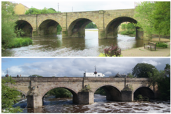
Wetherby Bridge
Wetherby Bridge is a scheduled monument and Grade II-listed bridge over the River Wharfe in Wetherby, West Yorkshire, dating from the 13th century. The bridge connects Micklethwaite on the south bank to the town centre on the north. It formerly carried the A1 Great North Road but now carries the A661 Boston Road leading to Boston Spa and the south.
2023 Walker Cup
The 49th Walker Cup Match was played on 2 and 3 September 2023 at Old Course at St Andrews in Scotland. It was the 9th Walker Cup Match to be played at St Andrews and the first since 1975. The United States won by 141⁄2 points to 111⁄2.

St Thomas' Church, Pendleton
St Thomas' Church is on Broad Street, Pendleton, Salford, Greater Manchester, England. It is an active Anglican parish church in the deanery of Salford, the archdeaconry of Salford, and the diocese of Manchester. Its benefice is united with those of five nearby churches including St Aidan’s, Lower Kersal; St Luke’s, Weaste; Emmanuel LEP, Langworthy and Holy Angels, Claremont to form the Salford All Saints' Team Ministry. The church is designated by English Heritage as a Grade II listed building. It was a Commissioners' church, having received a grant towards its construction from the Church Building Commission.

The Crossley Heath School
The Crossley Heath School is an 11–18 co-educational, grammar school and sixth form with academy status in Halifax, West Yorkshire, England. It was established in 1985 following the amalgamation of Heath Grammar School and Crossley and Porter School. It is part of The Crossley Heath School Academy Trust Limited.
Stewarton Academy
Stewarton Academy is a 11–18 co-educational, non-denominational secondary school in the town of Stewarton, East Ayrshire, Scotland. The current Head Teacher of Stewarton Academy is Mr John Stuart. As of August 2024, Stewarton Academy had a total of 904 pupils attending the school.

Hartsop
Hartsop is a small village in the English Lake District. It lies in the Patterdale valley, near Brothers Water, Hayeswater and Kirkstone Pass.
It consists of 17th-century grey stone cottages, like so many of its neighbours. Hartsop retains its historic image, in that, in common with a number of other small Cumbrian villages, it had houses with spinning galleries. It was also a lead mining community.
Hartsop Hall, in the care of the National Trust, is located on the far side of the valley from the village. The hall dates from the 16th century, formerly the home of the de Lancasters; in the 17th century it passed into the ownership of Sir John Lowther, a member of the family that later became Earls of Lonsdale. After that, it became used as an ordinary farmhouse. Local history relates that when the hall was extended in the 18th century, it was built across an ancient right-of-way, a right which at least one dalesman insisted on exercising, by walking through the hall.
Hayeswater, an upland lake a mile east above the village, serves as a reservoir for the town of Penrith about 12 miles away.
Hartsop is a popular starting point for hill walkers climbing on the High Street range and the Helvellyn range. The village is overlooked by Brock Crags and Hartsop Dodd.
Hartsop is part of the civil parish of Patterdale.

Edinburgh Filmhouse
The Edinburgh Filmhouse is a cinema located in Edinburgh, Scotland, which opened in 1979. It is home to the world's oldest continually running film festival, Edinburgh International Film Festival. The cinema closed in October 2022 when its parent body went into administration. In September 2023, a campaign organised by former staff to reopen the cinema got underway. The building re-opened in June 2025.


East Dunbartonshire (UK Parliament constituency)
East Dunbartonshire was a county constituency of the House of Commons of the Parliament of the United Kingdom (Westminster). It elected one Member of Parliament (MP) by the first past the post system of election. The seat is possibly best known for formerly being the constituency of Jo Swinson, the former Leader of the Liberal Democrats who was defeated at the 2019 general election.
This version of the constituency was first used at the 2005 general election. There was also an earlier East Dunbartonshire constituency, from 1950 to 1983.
Further to the completion of the 2023 review of Westminster constituencies, the seat was expanded and renamed Mid Dunbartonshire, and was first contested at the 2024 general election.
Letham, Angus
Letham (Scots pronunciation: [ˈlɛθəm]) is a village in Angus, Scotland.
Letham is the largest village in Angus, with a population of nearly 2,000. Situated 17 miles (27 km) from Dundee, 5 miles (8.0 km) from Forfar, 10 miles (16 km) from Arbroath and 10 miles (16 km) from Carnoustie.
There are some shops, including two groceries, one of which incorporates the Post Office and newsagent, a primary school, a bakery, a hairdresser, a take-away restaurant, a former hotel which now only functions as bar, the Commercial Inn and a widely known craft shop. The village is part of the parish of Letham, Dunnichen and Kirkden. In and around the Village is an extensive pattern of green paths which are kept cut by a group of volunteers, giving the village many and varied places to walk. . Many organisations and groups exist to enhance village life, the oldest of these being the Feuars Committee, which manages properties, held in trust for the people of the village.
Nearby is the village of Dunnichen, which is widely believed to be the site of the Battle of Nechtansmere, and the Hamlets of Bowriefauld and Craichie.
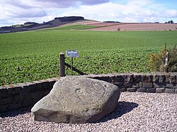
To the north of the village there is a Pictish stone with a cup and ring marking, locally known as the Girdlestane. Pictish stones have been found in many sites in Angus.
Letham is twinned with Monasterboice, County Louth, Ireland.

Pauper's Drain
Pauper’s Drain is a small tributary of the River Trent in North Lincolnshire, England, and is 9 km (6 miles) long.
It has a catchment area of 42 square kilometres(16 square miles) of flat arable, agricultural land to the east of the Isle of Axholme. The start of the drain is the outflow of the Crowle sewage treatment works; from there it flows in an eastwardly direction, south of the village of Eastoft before it reaches the Paupers pumping station at the side of the tidal River Trent, to the north of Amcotts.
The station contains three pumps, which are used to maintain water levels in the drain by discharging water into the Trent as required. A sluice adjacent to the pumping station, also allows water to discharge by gravity during periods of tidal low water.
The watercourse is essential for the land drainage of this low-lying area, which is the responsibility of the Isle of Axholme & North Nottinghamshire Water Level Management Board, the successor body to the Isle of Axholme Internal Drainage Board. The Board undertakes maintenance tasks such as annual mowing and rodding of the drain.
The name is thought to be derived from the fact that it was constructed by labourers on the poor rate (or paupers). It was also considered to have been constructed prior to the 17th century drainage works of Vermuyden in the area.

Edinburgh Air Charter Flight 3W
Edinburgh Air Charter Flight 3W was a charter flight from Glasgow to Aberdeen. On 3 September 1999, an engine failed during takeoff at Glasgow. The aircraft then crashed short of the runway, killing 8 of the 11 people on board. The Cessna 404 Titan was chartered by Edinburgh Air Charter but operating with Airtours and carrying Airtours employees. Later they would board an actual Airtours Boeing 757 for Palma de Mallorca.

Ashburys railway station
Ashburys railway station serves the area of Openshaw, in Greater Manchester, England. It is a stop on a junction of the Glossop Line, the Hope Valley Line and the freight line to Phillips Park Junction. It has been open since 1855 and is the nearest station to the City of Manchester Stadium.