
 English
 Français

Monk End Hall
Monk End House is a historic building in Croft-on-Tees, a village in North Yorkshire, in England.
In the mediaeval period, a house on the site was owned by St Mary's Abbey, York. The current building may retain some 15th century material, but mainly dates from the early 18th century. At one time, the conservatory was used as a schoolroom. The house was grade II listed in 1968. In 2011, it was sold for £2.25 million, the most expensive property in the Darlington area between 2000 and 2024.
The house is built of brown brick, with a dentilled eaves course and a hipped Westmorland slate roof. There is a U-shaped plan, with a main range of three storeys and five bays. In the centre of the east front is a round-arched doorway with Roman Doric three-quarter columns with fluted capitals, an entablature with paterae, a fanlight with decorative glazing, and an open pediment. The windows are sashes with flat brick arches. At the rear is a chamfered mullioned basement window, and in the left return is a two-storey canted bay window.

Bensham
Bensham is a suburban area in the Metropolitan Borough of Gateshead, Tyne and Wear, England. The area consists mainly of residential properties, with a range of predominantly terraced housing, built between the late 1890s and the 1980s.

Baxenden railway station
Baxenden railway station served the villages of Baxenden in Hyndburn and Rising Bridge in Rossendale. It was situated just inside the old boundary of Haslingden on the line from Bury Bolton Street to Accrington, which was opened in 1848 by the East Lancashire Railway. The station gave its name to the nearby Baxenden Bank, the two-mile section towards Accrington that included gradients as steep as 1 in 38.
The Accrington Corporation Steam Tramways Company built a tramline from Accrington in 1887 that terminated at the station. The station closed to passengers in 1951, some fifteen years before the line serving it suffered a similar fate.

Church of the Immaculate Conception, Spinkhill
Immaculate Conception Church is a Roman Catholic Parish church in Spinkhill, Derbyshire, England. It was built in 1846 and designed by Joseph Hansom. It is situated on Spinkhill Lane opposite Immaculate Conception Catholic Primary School south of Mount St Mary's College in the village. It was founded by the Jesuits and is a Grade II listed building.
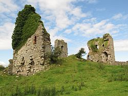
Gleaston Castle
Gleaston Castle is a medieval building in a valley about 1 kilometre (0.62 mi) north-east of the village of Gleaston. The village lies between the towns of Ulverston and Barrow-in-Furness in the Furness peninsula, Cumbria, England. Gleaston Castle has a quadrilateral plan, with a tower at each corner. The largest of these, the north-west tower, probably housed a hall.
The castle was most likely built for John Harington, 1st Baron Harington in the 14th century, replacing nearby Aldingham Motte. Gleaston Castle descended through the Harrington family until 1458 when it passed to William Bonville through marriage and was subsequently abandoned. The castle passed to the Grey family until Henry Grey, 1st Duke of Suffolk was executed for treason in 1554. As a result, Gleaston Castle became royal property before it was bought by the Preston family in the 17th century, and then passed to the Cavendish family.
As the castle was disused from the mid-15th century it fell into dilapidation, and antiquarian depictions from the 18th century show Gleaston in a state of ruin. Though it is not open to the public, it has been the subject of historical and archaeological investigation in the 20th and 21st centuries.

Doncaster Greyhound Stadium
Doncaster Greyhound Stadium is a greyhound racing track located in Stainforth, near Doncaster, England.
It is sometimes referred to as Meadow Court Stadium and was previously known as Stainforth Stadium. It is not to be confused with the former Doncaster Greyhound Track that existed near the York Road.
The stadium has executive suites, a restaurant, a number of bars and fast food areas. Racing takes place every Monday and Wednesday night, Saturday afternoon and Sunday morning.

Collingwood Dock
Collingwood Dock is a dock on the River Mersey, in England, and part of the Port of Liverpool. It is situated in the northern dock system in Vauxhall, and is connected to Stanley Dock to the east and Salisbury Dock to the west.
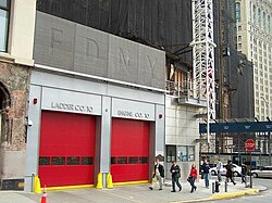
Firehouse, Engine Company 10 and Ladder Company 10
Firehouse, Engine Company 10 and Ladder Company 10, is a New York City Fire Department (FDNY) fire station, located at 124 Liberty Street across from the World Trade Center site and the National September 11 Memorial & Museum in the Financial District neighborhood of Manhattan, New York City. It is known for being the first fire station to respond to the terrorist attacks at the World Trade Center on September 11, 2001.

Maisel Synagogue
The Maisel Synagogue (Czech: Maiselova synagoga) is a Jewish congregation and synagogue, located in the former Jewish quarter of Prague, in the Czech Republic. The synagogue was built at the end of the 16th century in the Gothic Revival style. Since then its appearance has changed several times. The synagogue belongs to the Jewish Community of Prague and is administered by the Jewish Museum in Prague as a part of its exhibitions.

Nantwich Workhouse
Nantwich Workhouse, also known as Nantwich Union Workhouse, Nantwich Union House and Nantwich Institution, is a former workhouse in Nantwich, Cheshire, England. It is located at The Barony, off Barony Road (at SJ65295338). Built in 1779–80 to accommodate up to 350 people, the institution remained in use as a workhouse until 1930.
For much of the remainder of the 20th century, the former workhouse became part of Barony Hospital, and is currently used as offices for the National Health Service. The former workhouse is listed at grade II.

North East Coast Exhibition
The North East Coast Exhibition was a world's fair held in Newcastle, Tyne and Wear and ran from May to October 1929. Held five years after the British Empire Exhibition in Wembley Park, London, and at the start of the Great Depression the event was held to encourage local heavy industry.

Birtle, Greater Manchester
Birtle is an affluent hamlet Historically in the parish of Bury, Lancashire, now within the Metropolitan Borough of Rochdale, in Greater Manchester, England. It lies in the Cheesden Valley, set amongst the Pennines.
Historically a part of Lancashire, Birtle is archaically referred to as Bircle or Birkle, which means Birch Hill. Together with neighbouring Bamford, it formed the civil parish of Birtle-with-Bamford (also known as Birtle-cum-Bamford). It was in Middleton ecclesiastical parish and in Bury poor law Union. In 1933, Birtle-with-Bamford was dissolved with Birtle being amalgamated into the Municipal Borough of Heywood.
The local church is Bircle Church, St. John the Baptist, Castle Hill Road, Bircle, Bury. In addition to the graveyard and garden of remembrance, the Church land includes an area now known as 'Bircle Church Wood', which was gifted by the Reverend Trend Smith.

Burnrigg
Burnrigg is a hamlet in Cumbria, England. It is located to the east of Carlisle. In 1887, The British Architect said "on a site particularly high and open, are two small two- storied blocks of tenements, in all thirty-two, two small rooms to each, no other accommodation except four privies".

Ayrshire
Ayrshire (Scottish Gaelic: Siorrachd Inbhir Àir, pronounced [ˈʃirˠəxk iɲiˈɾʲaːɾʲ]) is an historic county and registration county, in south-west Scotland, located on the shores of the Firth of Clyde. The lieutenancy area of Ayrshire and Arran covers the entirety of the historic county as well as the island of Arran, formerly part of the historic county of Buteshire. Its principal towns include Ayr, Kilmarnock and Irvine and it borders the counties of Renfrewshire and Lanarkshire to the north-east, Dumfriesshire to the south-east, and Kirkcudbrightshire and Wigtownshire to the south. Like many other counties of Scotland, it currently has no administrative function, instead being sub-divided into the council areas of East Ayrshire, North Ayrshire and South Ayrshire. It has a population of approximately 366,800.
The electoral and valuation area named Ayrshire covers the three council areas of East Ayrshire, North Ayrshire and South Ayrshire, therefore covering the whole historic county of Ayrshire but also including the Isle of Arran, Great Cumbrae and Little Cumbrae from the historic county of Buteshire. The three council areas together also form the Ayrshire and Arran lieutenancy area.
The largest settlement in Ayrshire by population is Kilmarnock, closely followed by Ayr, the county town.

Moorepark, Glasgow
Moorepark is a small area in the Scottish city of Glasgow. Situated south of the River Clyde and part of the former Burgh of Govan, it was colloquially referred to as 'Wine Alley' during the mid-to-late 20th century when a housing scheme with a rough reputation was sited there. It is now an industrial estate.

Swallow, Lincolnshire
Swallow is a small village and civil parish in the West Lindsey district of Lincolnshire, England, on the A46 road 4 miles (6.4 km) north-east from Caistor. The population (including Cabourne and Cuxwold) taken at the 2011 census was 289.

Highfield, North Ayrshire
Highfield is a small village or hamlet in North Ayrshire, Parish of Dalry, Scotland. It is situated between the settlements of Barkip and Dalry on the A737 at a junction with the B777. It lies in the lands of the old Barony of Kersland, the ruins of Kersland Castle and East Kersland Mill being situated nearby at East Kersland.

Vale of Edale
The Vale of Edale is the upper valley of the River Noe, in the Derbyshire Peak District of England. The village of Edale lies in the middle of the valley.
Edale Head, on the Kinder Scout plateau, is the source of the River Noe (a tributary to the River Derwent). The River Noe flows out of the foot of the Vale of Edale into Hope Valley, past the village of Hope and through Brough-on-Noe, where the Romans established Navio fort.
On the north side of the valley is the Kinder moorland plateau. On the south side is the ridge of Rushup Edge and Great Ridge, over Mam Tor and Hollins Cross to Lose Hill. The other settlements in the valley are the hamlets of Upper Booth, Barber Booth and Nether Booth.
The Hope Valley railway line (Manchester to Sheffield) runs along the Vale of Edale. The train line, built by Midland Railway, and Edale railway station were opened in 1894. At the western end of the Vale of Edale the line heads through the 3.4 kilometres (2.1 miles) long Cowburn Tunnel at Dale Head, under the moorland hill of Brown Knoll.Edale is the start of the Pennine Way long distance footpath, which runs from Derbyshire to Scotland. The trail heads west through Upper Booth and up Jacob's Ladder footpath to the Kinder plateau. At the foot of Jacob's ladder is a gritstone packhorse bridge, with a single span which crosses the River Noe. It is a designated Grade II structure. The bridge is on an important medieval packhorse route over the Pennine moorland between Hayfield and Edale. Salt and cheese from Cheshire and cotton from the Lancashire mills were transported to the east, while coal and lead were carried to the west. Doctor's Gate Roman road ran along the hillside at the eastern end of the valley.
The land along the banks of the River Noe between Barber Booth and Jacob's Ladder is protected as Edale SSSI (Site of Special Scientific Interest). The banks and riverbed contain important fossils from the rocks known as Edale Shales. There are kestrels, buzzards and curlews in the valley. The trees along the hillsides include birch, rowan and alder. Jacob's ladder footpath runs across land that is owned and managed by the National Trust. It is also part of the Kinder Scout SSSI, which was designated as a National Nature Reserve in 2009.

Brawith Hall
Brawith Hall is a historic building in Brawith, a hamlet in North Yorkshire, in England.
There was a Mediaeval manor house in Brawith. In the early 18th century, it was demolished and the current hall was built, facing south. In the late 19th century, a rear range was added. Part of the east front was rebuilt in the 20th century. The building was grade II* listed in 1952. The Victoria County History describes it as having a "fine park on the banks of the Cod Beck".
The house is built of red and pale brown brick, with sandstone dressings, a hipped Westmorland slate roof, two storeys and attics. The south front has five bays on a stone plinth, with giant pilasters and a parapet. It has a chamfered floor band, a moulded cornice with a pulvinated frieze over the ground floor, and a cornice under the parapet. Steps lead up to the central doorway that has an eared architrave, and a pediment containing a pulvinated frieze on consoles. The windows are sashes in architraves, with coved lintels and chamfered sills, the window above the doorway with a rusticated surround. The east and west fronts have four bays. Inside, there is a grand staircase hall, and two ground floor rooms with early-18th century decoration.

Gillender Building
The Gillender Building was an early skyscraper in the Financial District of Manhattan in New York City. It stood on the northwest corner of Wall Street and Nassau Street, on a narrow strip of land measuring 26 by 73 feet (7.9 m × 22.3 m). At the time of its completion in 1897, the Gillender Building was, depending on ranking methods, the fourth- or eighth-tallest structure in New York City.
The Gillender Building was designed by Charles I. Berg and Edward H. Clark, and rose 273 feet (83 m) with 20 stories, comprising 17 floors in the main body and three floors in a cupola. The building contained a fully wind-braced steel frame with masonry infill, and included twelve columns atop three caisson foundations. On its completion, it was praised as an engineering novelty. It attracted attention for its disproportionate height and its low total rentable area of only about 30,000 square feet (2,800 m2).
The Gillender Building was occupied by financial firms through its uneventful 13-year existence and was perceived as economically obsolete from the start. In 1909, financial institutions began rapidly expanding their properties within the Financial District, and that December, the building was sold to Bankers Trust for a then-record price of $822 per square foot ($8,850/m2). The Gillender Building was demolished between April and June 1910 to make way for Bankers Trust's 39-story tower at 14 Wall Street, and much of the material from the building was saved. At the time, the Gillender Building was the tallest building ever demolished voluntarily.