
 English
 Français

Muncaster Fell
Muncaster Fell is a fell at the far western edge of the Lake District National Park, in Cumbria, England. Muncaster Fell is a long, narrow ridge of land, approximately 1.2 km wide and 6 km long, lying between the River Mite to the north, and River Esk to the south. The fell rises from the coast near Ravenglass village to its highest point at Hooker Crag (231 m). The ridge then continues to the north-east, dropping gently to its furthest prominence at Silver Knott (174 m). The fell then falls away rapidly to the village of Eskdale Green at its north-eastern tip.

Skelsmergh and Scalthwaiterigg
Skelsmergh and Scalthwaiterigg is a civil parish in Westmorland and Furness district, Cumbria, England. It was formed on 1 April 2015 by merging the parishes of Skelsmergh and Scalthwaiterigg, which had shared a parish council since 2007.
The parish is divided into two wards, separated by the River Mint and named for the two previous parishes. Skelsmergh parish ward (north of the river) is represented by five councillors, and Scalthwaiterigg parish ward (south of the river) by two councillors, a pattern established in 2007.
The population of the former parish of Skelsmergh was 303 in the 2011 United Kingdom census; the 2011 population of the former parish of Scalthwaiterigg is not available, but its 2001 population was 104. (the 2001 population of Skelsmergh was 271).
The areas of the two former parishes were 7.8435 km2 (3.0284 sq mi) (Skelsmergh) 4.22 km2 (1.63 sq mi) (Scalthwaiterigg), giving an area for the current parish of 12.02635 km2 (4.64340 sq mi). The southern part of the parish includes the 317 metres (1,040 ft) hill Benson Knott, which is classified as a HuMP, a TuMP and a Clem. The A6 from Kendal to Shap, the A685 road from Kendal to Tebay, and the Dales Way footpath from Ilkley to Bowness all pass through the parish.
There are eight listed buildings in the parish, all at grade II.

Tentsmuir National Nature Reserve
Tentsmuir National Nature Reserve (NNR) is located southeast of Tayport in Fife, Scotland. The reserve is made up of three parts, encompassing Morton Lochs, Tentsmuir Point and Tayport Heath, and is managed by NatureScot. The different sections of Tentsmuir NNR were originally designated as separate national nature reserves at different times: the Morton Lochs section was designated in 1952; Tentsmuir Point in 1954; and Tayport Heath in 1988. While these discrete sections are distant from one another, they form part of the extensive dune system at Tentsmuir, and in 2003 SNH combined the three sites to form Tentsmuir National Nature Reserve. The adjoining Tentsmuir Forest is managed by Forestry and Land Scotland and covers most of the land between the three portions of the NNR.
In October 2020 Tentsmuir was one of the sites used for the filming of the BBC's Autumnwatch series, with presenter Michaela Strachan being based at the site for the programme's two week run.

Steeple Church
The Steeple Church occupies the western part of the historic "City Churches" building in Dundee, Scotland. It is a congregation of the Church of Scotland.
The "City Churches" are located in the city centre, adjacent to the Overgate shopping centre. The building is unusual as having two congregations within the same structure – the other congregation (at the eastern end) is Dundee Parish Church (St Mary's). The middle building ceased functioning as a place of worship in the early 1990s.
St Mary's Tower, the clock tower at the western end of the City Churches, is the oldest part of the church, and is currently operated by Dundee City Council's heritage department and is commonly referred to as the Old Steeple by locals.
During the war between Scotland and England known as the Rough Wooing, Dundee and Broughty Castle were occupied by English forces. In January 1548, an English commander, Thomas Wyndham placed a garrison of 20 "tall men" in the steeple, with the help of Andrew Dudley and the Scottish Lord Gray. Their armaments included cannon described as "a saker and a falcon and four double bases" and small guns called "hackbuts of crook".

Sorn, East Ayrshire
Sorn (Scottish Gaelic: Sorn, meaning a kiln) is a small village in East Ayrshire, Scotland. It is situated on the River Ayr. It has a population of roughly 350. Its neighbouring village is Catrine. Sorn Castle lies just outside the village.

Sholver
Sholver is an area of Oldham, in Greater Manchester, England. An elevated, residential area, it lies near the middle of the Oldham part of the valley of the River Beal, two miles (three kilometres) northeast of Oldham's commercial centre, nearly at the northeasternmost extremity of the town, by open countryside close to the source of the River Medlock and by the border with Saddleworth.
Historically a part of Lancashire, Sholver and its surroundings have provided archaeological evidence of Neolithic activity in the area. The name Sholver is of Old Norse derivation, and the locality, anciently, was a hamlet, independent of Oldham. Top Sholver is the site of a large council estate built in the 1960s. Bottom Sholver consists of higher-value suburban semi-detached housing, built in the 1990s, although it still contains a very small number of council houses.
Locations within the area like Sholver Millennium Green Beasom Hill Country Park Strinesdale, Fullwood Nature Reserve and Community Garden are all particularly nice areas to visit.

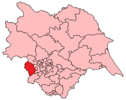
Doncaster Central
Doncaster Central is a constituency represented in the House of Commons of the UK Parliament since 2024 by Sally Jameson of the Labour Party.

Little Hayfield
Little Hayfield is a hamlet in the Peak District National Park, in Derbyshire, England. It lies on the A624 between Hayfield and Glossop. At the centre of the hamlet is the Lantern Pike pub, named after the nearby hill of the same name. Fell racing take place in Little Hayfield, and until 2021 an annual country show was held on a local farm, including sheepdog trials.
From Clough Mill, a former water-powered and later steam-powered textile mill converted to apartments in 1989, a footpath leads to the summit of Lantern Pike.
The screenwriter Tony Warren lived in the village, and is said to have conceived the soap opera Coronation Street in the Lantern Pike pub. Actors Pat Phoenix and Kenneth Cope had spells living in the village, as did producer Bill Podmore.

2nd White Cloth Hall
The 2nd White Cloth hall was a marketplace for the sale of undyed cloth in Holbeck, Leeds, West Yorkshire, England.
It was built south of the river, between Meadow Lane and Hunslet Lane in 1756 to replace the 1st White Cloth Hall of 1711. The 2nd cloth hall was much larger than its predecessor but it only served 20 years until the construction of the enormous 3rd White Cloth Hall.
The building was demolished in 1786, only 30 years after its construction. The only part of the building to survive was the cupola which was transferred to the 3rd White Cloth Hall.

Gosforth Cross
The Gosforth Cross is a large stone monument in St Mary's churchyard at Gosforth in the English county of Cumbria, dating to the first half of the 10th century AD. Formerly part of the kingdom of Northumbria, the area was settled by Scandinavians some time in either the 9th or 10th century. It has gained reputation for its combination of Christian symbols with Nordic symbols, being a tangible piece of evidence of the impact of the Christianization of Scandinavia.
The deities depicted on the monument have been identified with Sigyn attempting to protect her bound husband Loki, a horn-wielding Heimdallr, Víðarr in the process of defeating Fenrir, and Thor in a failed attempt to capture Jörmungandr. The images likely adapt scenes from the Poetic Edda. Also depicted on the monument is the crucifixion of Jesus. The tree-like design of the base of the cross may represent Yggdrasil or a mythical tree of life.
Sowerby (UK Parliament constituency)
Sowerby () was a county constituency centred on the village of Sowerby in Calderdale, West Yorkshire. It returned one Member of Parliament (MP) to the House of Commons of the Parliament of the United Kingdom.

Stainforth Force
Stainforth Force (also known as Stainforth Foss and Ribble Falls), is a 2.5-metre (8 ft 2 in) high cascade waterfall on the River Ribble at Stainforth, 3 miles (5 km) north of Settle in North Yorkshire, England. The waterfall is a popular tourist attraction in autumn when Atlantic salmon are migrating up the river.

Dalton, South Yorkshire
Dalton is a civil parish in the Metropolitan Borough of Rotherham in South Yorkshire, England. Dalton is situated 162 miles (260.7 km) north from London and is 2 miles (3.2 km) north-east from the centre of Rotherham town centre. The population of the parish as taken at the 2011 Census was 10,292. The parish includes the communities of Brecks, Dalton Brook, Dalton Foljambe, Dalton Magna, Dalton Parva, Flanderwell, Sunnyside and Woodlaithes.

Beetham
Beetham is a village and civil parish in Westmorland and Furness, Cumbria, England. It is situated on the border with Lancashire, 6 miles (10 km) north of Carnforth. It is part of the Arnside and Silverdale Area of Outstanding Natural Beauty. In the 2001 census the parish had a population of 1,724, increasing at the 2011 census to 1,784.
Diocese of Salford
The Diocese of Salford (Latin: Dioecesis Salfordensis) is a Latin diocese of the Catholic Church centred on the City of Salford in Greater Manchester, England. The diocese was founded in 1852 as one of the first post-Reformation Catholic dioceses in Great Britain. Since 1911 it has formed part of the Province of Liverpool.
Its current boundaries encompass Manchester as well as a large part of North West England between the River Mersey and the River Ribble, some parishes north of the Ribble, and Todmorden in West Yorkshire. In 2005, the diocese included 207 churches and chapels.

Caer Mote
Caer Mote is a hill of 289 metres (948 ft) in the north of the English Lake District near Bothel, Cumbria. Its summit lies just outside the boundary of the Lake District National Park and offers a view of Bassenthwaite Lake. Under the name Caermote Hill it is the subject of a chapter of Wainwright's book The Outlying Fells of Lakeland. Wainwright's route is an ascent from Bothel to the northern summit St. John's Hill at 285 metres (935 ft), continuing south to the main summit and south east to meet a minor road beside the Roman fort and follow that road north for an anticlockwise circuit. In his original book Wainwright lists the height as 920 feet (280 m), but in the 2011 2nd edition Chris Jesty corrects this to 948 feet.
There is an ancient earthwork enclosure of undetermined age, known as "The Battery" on the northern summit, St. John's Hill. There are traces of a 1st-century AD Roman fort below the hill, to the south east.
Caermote Hill is listed by the Database of British and Irish Hills as a TuMP, and St John's Hill is given the subtitle "Caermote Hill N Top"; both summits are recognised as "Wainwright Outlying Fells".

Fingask Castle
Fingask Castle is a country house in Perth and Kinross, Scotland. It is perched 200 feet (61 m) above Rait, three miles (5 km) north-east of Errol, in the Braes of the Carse, on the fringes of the Sidlaw Hills. Thus it overlooks both the Carse of Gowrie and the Firth of Tay and beyond into the Kingdom of Fife. The name derives from Gaelic fionn-gasg: a white or light-coloured appendage.
Fingask was once an explicitly holy place, a convenient and numinous stop-off between the abbeys at Falkirk and Scone. It was later held by the Bruce family, and then by the Threiplands. In the eighteenth century it was owned by Jacobites and was forfeited. The castle is a Category B listed building, and the estate is included on the Inventory of Historic Gardens and Designed Landscapes, the national register of significant gardens.

Wentworth College, York
Wentworth College is a college of the University of York, named after Thomas Wentworth, 1st Earl of Strafford.

St Philip's Church, Hassall Green
St Philip's Church is in New Inn Lane, Hassall Green, Cheshire, England. It is an active Anglican church in the parish of Wheelock, the benefice of Sandbach Heath with Wheelock, the deanery of Congleton, the archdeaconry of Macclesfield, and the diocese of Chester. The other churches in the benefice are St John the Evangelist, Sandbach Heath, and Christ Church, Wheelock. Being a prefabricated building constructed in corrugated galvanised iron, it is popularly referred to as a tin tabernacle.

Micklethwaite, Cumbria
Micklethwaite is a hamlet in Cumbria, England, close to the Lake District.
It is situated to the north east of Wigton.