
 English
 Français
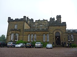
Oxenfoord Castle
Oxenfoord Castle is a country house in Midlothian, Scotland. It is located 1 kilometre (0.62 mi) north of Pathhead, Midlothian, and 6 kilometres (3.7 mi) south-east of Dalkeith, above the Tyne Water. Originally a 16th-century tower house, the present castle is largely the result of major rebuilding in 1782, to designs by the architect Robert Adam. Oxenfoord was the seat of the Earl of Stair from 1840, and remains in private ownership. It is protected as a category A listed building, while the grounds are included in the Inventory of Gardens and Designed Landscapes in Scotland.

St Mary's Church, Ulverston
Ulverston Parish Church is in Church Walk, Ulverston, Cumbria, England. It is an active Anglican parish church in the deanery of Furness, the archdeaconry of Westmorland and Furness, and the diocese of Carlisle. Its benefice is united with that of St John, Osmotherley. The church is recorded in the National Heritage List for England as a designated Grade II* listed building.

Winscar Reservoir
Winscar Reservoir (also known as Winscar dam), is a compensation reservoir on the headwaters of the River Don in South Yorkshire, England. The reservoir is located at Dunford Bridge in Barnsley 25 miles (40 km) northwest of Sheffield, and is just inside the Peak District National Park on the Pennine watershed. The reservoir was built on an existing dam and has suffered from leaking which necessitated a new membrane being installed at the dam head in the years 2000 and 2001.
It was the first major dam to be built in England with an asphaltic concrete membrane on the upstream dam wall and was the last dam to be built that was fed from the River Don.

Wetwang railway station
Wetwang railway station (SE933596) was a railway station on the Malton & Driffield Railway in the East Riding of Yorkshire, England. It served the village of Wetwang, opened on 19 May 1853, and closed for passengers on 5 June 1950 and goods on 20 October 1958. For passenger traffic, Wetwang was the busiest station on the MDR.

Brooklands (Manchester ward)
Brooklands is an area and electoral ward of Manchester, England. It is represented in Westminster by Mike Kane, MP for Wythenshawe and Sale East. The 2011 Census recorded a population of 14,362.
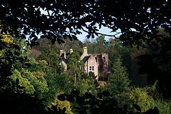
Hawthornden Castle
Hawthornden Castle is located on the River North Esk in Midlothian, Scotland. The castle lies a mile to the east of Roslin at grid reference NT287637, and is just downstream from Roslin Castle. Hawthornden comprises a 15th-century ruin, with a 17th-century L-plan house attached. The house has been restored and now serves as a writer's retreat. Man-made caves in the rock beneath the castle have been in use for much longer than the castle itself.

Eastfield, South Lanarkshire
Eastfield is a mainly residential district in South Lanarkshire, Scotland, located between the industrial towns of Rutherglen and Cambuslang in the south-east of the Greater Glasgow urban area. It is situated south of the River Clyde, adjoining the Stonelaw and Burnside neighbourhoods of Rutherglen, and Silverbank in Cambuslang.

Chapeltown railway station
Chapeltown railway station, originally known as Chapeltown South, is a railway station serves the Sheffield suburb of Chapeltown in South Yorkshire, England. The station is 7+1⁄4 miles (12 km) north of Sheffield on the Hallam and Penistone Lines. As you enter the station on the Asda side you can see the old platforms.

Meigle Cricket Club
Meigle Cricket Club is a cricket club in Meigle, Perthshire, Scotland.
Established in 1876, it has won the Strathmore & Perthshire Cricket Union, of which it was a founder member in 1929, on eight occasions 2022, 2019, 2014, 2001, 1998, 1980, 1961 and 1954. The club was second to Brechin in the inaugural season.
The 1st XI played in the Cricket Scotland Eastern Premier League in 2021 and the club 2nd and 3rd XI play in the Strathmore & Perthshire Cricket Union lower divisions. The Union is one of three regional feeder leagues to the Cricket Scotland League set up. The club has long running rivalry with Freuchie Cricket Club from Fife from many years competing in the Scottish section of the National Village Cup which the club has won ten times, the first year of the Village Cup in 1972 and the most recent success was 2022 in a 5 wicket win over Falkland to make it three titles in a row. From the mid nineties to the late noughties the club were deemed ineligible for the competition. Meigle became eligible again in 2011 and in 2013 lost the Scottish final to Dumfries-shire side Kirkwood.
The club play at Victory Park which has a slight slope, though the other park in the Village, Belmont Park has also hosted cricket in the past. In 2001 the club, captained by Peter J. Drummond who later captained Forfarshire in the Scottish National Cricket League, played in the annual Play-Off to enter the Scottish National Cricket League but lost to Border League champions Penicuik. The 1st XI has also won the main Twenty20 cup for the North District, the Three Counties Cup (originally Forfarshire, Perthshire & Aberdeenshire) on six occasions 1951, 1980, 1983, 1984, 1998 and 2000 and have been runners up nine times, the last final appearance being in 2018
The 2001 undefeated league winning team are known as 'the invincibles', but the greatest team in the club's history is regarded by many to be the 1980 treble winning team. A short lived league cup 'The 3 D Sports Premier Trophy' was played for in 1999 and Meigle reached the final, but suffered a batting collapse and lost out to Gordonians at Guthrie Park, Brechin. Meigle had won their section with 100% record in a group with Dundee HSFP, Brechin and Cupar (Fife). The club have played in the Scottish Cup in six seasons, often qualifying by winning the Strathmore Union, or finishing in a high position.
The Meigle 2nd XI has won a 2nd XI title on five occasions; 1932, 1958, 1959, 1984 and 2018. The 2nd XI has won the Two Counties Cup on three occasions 1985, 1987 and 2000. The Strathmore Union allowed the Perthshire League to join it in 2004.
The club's greatest ever player is WB Scott, better known as Bill Scott. In 1997, in a match versus Arbroath United he became the first batsman to amass 10,000 league runs. He is also often referred to as 'the best amateur batsman never to have played for Scotland', he finished with over 13,000 runs in the Union top flight.

Northorpe North Road railway station
Northorpe North Road railway station served the town of Northorpe, West Riding of Yorkshire, England, from 1891 to 1965 on the Spen Valley Line.

Somerford, Cheshire
Somerford is a civil parish in the unitary authority of Cheshire East and the ceremonial county of Cheshire, England. It is adjacent to the north west of Congleton, from which town it has some housing overflow. According to the 2001 census, the population of the civil parish was 343, increasing to 430 at the 2011 Census.
Somerford Park was the site of a Georgian country house demolished in 1926. The park has now been restored to farming and an equestrian centre. All Saints Chapel was built in 1720 as a chapel to Somerford Hall. It still stands and is listed at grade II*.

Arlington Baths Club
Arlington Baths Club is a non-profit member-run swimming club in Glasgow. The Arlington Baths Club was the first swimming club in Glasgow and is located in a purpose-built Category A Listed Building that opened on 1 August 1871.
The building is in the Charing Cross neighbourhood and was part of the westward development of the city. It was designed largely in the traditional tenement idiom, albeit with some exceptions such as the famous Charing Cross Mansions. The area quickly attracted well-off middle-class residents who were the primary members of the Arlington Baths Club.
The membership typically showed up first thing in the morning before leaving for work and returned in the evening after work before leaving for home. These behaviours created the Club's customs.
A replica of the Arlington Baths was built soon after in London, however, the drawings of the Arlington were stolen sometime towards the end of the 19th century. This replica was bombed during the Second World War and was never rebuilt. The building of the Arlington Baths coincided with the implementation of the first of the Public Health Acts in 1870 and was considered by some to be the precursor to the growth of public bathing in the United Kingdom.

Wath TMD
Wath TMD was a motive power depot located in Wath upon Dearne, South Yorkshire, England. The depot was located near Wath station.
The depot code is WH.

The Bay Hotel
The Bay Hotel is a public house in Robin Hood's Bay, North Yorkshire, England. The pub is known for being a destination for coast-to-coast walkers, for once being washed into the sea (then rebuilt), and also for having its windows wrecked by the bowsprit of ship during a heavy storm. The Bay Hotel stands at the very edge of the sea wall at Robin Hood's Bay facing out towards the sea, and is the second inn to be sited at that location. It is a grade II listed building.

Gretna Green railway station
Gretna Green is a railway station on the Glasgow South Western Line, which runs between Carlisle and Glasgow Central via Kilmarnock. The station, situated 9 miles 58 chains (16 km) north-west of Carlisle, serves the town of Gretna and village of Gretna Green in Dumfries and Galloway, Scotland. It is owned by Network Rail and managed by ScotRail.
Killingholme Admiralty Platform railway station
Killingholme Admiralty Platform railway station, known locally as Admiralty Platform, was near North Killingholme Haven, Lincolnshire, England.
The station was opened by the Great Central Railway in 1913 a later addition to the branch line from Goxhill to Immingham Dock, near both the former seaplane base at RNAS Killingholme and the Admiralty oil terminal at North Killingholme Haven.
Like its neighbour Killingholme, Admiralty Platform had a single, straight, wooden platform with minimal facilities. These were still intact when a RCTS Special called four years after closure on 7 October 1967.
The station was unusual in several respects:
although opened primarily to serve a naval base it was a public station, at least outside wartime
it evaded maps, including OS maps
it evaded timetables
it evaded Signalling Record Society records
and
no tickets were thought to survive which show the station as a starting point, but an example has now been found, (see picture).
The station closed on 17 June 1963 along with the other stations on the line.
When the line and station opened the area was rural and thinly populated. By 2015 the area round the former station had become industrial but remained thinly populated. The track through the station site was still in use for freight.
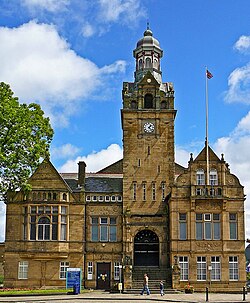
Cleckheaton Town Hall
Cleckheaton Town Hall is a municipal building in Bradford Road, Cleckheaton, West Yorkshire, England. The town hall, which was the headquarters of Spenborough Urban District Council, is a Grade II listed building.

Glassford
Glassford (; locally known as The Glesart ) is a small village located 8 kilometres (5 mi) south of Hamilton, and 3 kilometres (2 mi) north-east of Strathaven, in South Lanarkshire, Scotland. It has a population of roughly 500–600 people. Features include the 19th-century Parish Church, and the remains of the 17th-century church, both of which are category B listed buildings. The Avon Water offers fishing and walks. The local No.13 or No 256 bus service comes through the village once every hour.

Haltwhistle
Haltwhistle is a market town and civil parish in Northumberland, England, 23 miles (37 kilometres) east of Carlisle and 37 miles (60 kilometres) west of Newcastle upon Tyne. It had a population of 3,811 at the 2011 Census.
Haltwhistle is the closest community to Hadrian's Wall and to Northumberland National Park, both approximately 2 miles (3 kilometres) distant.

Fletcher's Canal
Fletcher's Canal was a 1.5-mile (2.4 km) long canal in Greater Manchester, which connected the Wet Earth Colliery to the Manchester, Bolton and Bury Canal at Clifton Aqueduct. The canal is now derelict and no longer used.
The canal was built on the south bank of the River Irwell through the area now known as Clifton Country Park. West of Pilkington's long sections of the canal are evident, although none of these sections hold water. As the canal passes through Clifton Country Park a footpath is maintained along the former towpath. Some of the original features are still evident, albeit in extremely poor condition.