Hadrian's Wall (Latin: Vallum Hadriani; also known as the Roman Wall, Picts' Wall, or Vallum Aelium in Latin) is a former defensive fortification of the Roman province of Britannia, begun in AD 122 in the reign of the Emperor Hadrian. Running from Wallsend on the River Tyne in the east to Bowness-on-Solway in the west of what is now northern England, it was a stone wall with large ditches in front and behind, stretching across the whole width of the island. Soldiers were garrisoned along the line of the wall in large forts, smaller milecastles, and intervening turrets. In addition to the wall's defensive military role, its gates may have been customs posts. Hadrian's Wall Path generally runs close along the wall. Almost all the standing masonry of the wall was removed in early modern times and used for local roads and farmhouses. None of it stands to its original height, but modern work has exposed much of the footings, and some segments display a few courses of modern masonry reconstruction. Many of the excavated forts on or near the wall are open to the public, and various nearby museums present its history. The largest Roman archaeological feature in Britain, it runs a total of 73 miles (117.5 kilometres). Regarded as a British cultural icon, Hadrian's Wall is one of Britain's major ancient tourist attractions. It was designated a UNESCO World Heritage Site in 1987. The turf-built Antonine Wall of AD 142 in what is now central Scotland, which briefly superseded Hadrian's Wall before being abandoned, was declared a World Heritage Site in 2008. Hadrian's Wall lies entirely within England and has never formed the Anglo-Scottish border, though it is sometimes loosely or colloquially described as such.

Nearby Places View Menu
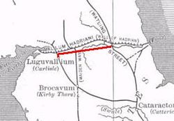
Location Image
1.3 km

Stanegate

The Stanegate (meaning "stone road" in Northumbrian dialect) was an important Roman road and early frontier built in what is now northern England. It linked many forts including two that guarded important river crossings: Corstopitum (Corbridge) on the River Tyne in the east (situated on Dere Street) and Luguvalium (Carlisle) on the River Eden in the west. The Stanegate ran through the natural gap formed by the valleys of the River Tyne in Northumberland and the River Irthing in Cumbria. It predated the Hadrian's Wall frontier by several decades; the Wall would later follow a similar route, albeit slightly to the north. The Stanegate should not be confused with the two Roman roads called Stane Street in the south of England, namely Stane Street (Chichester) and Stane Street (Colchester). In both these cases the meaning is the same as for the northern version, indicating a stone or paved road. The Stanegate differed from most other Roman roads in that it often followed the easiest gradients, and so tended to weave around, whereas typical Roman roads follow a straight path, even if this sometimes involves having punishing gradients to climb. A large section of the Stanegate is still in use today as a modern minor road between Fourstones and Vindolanda in Northumberland.
Location Image
1.4 km

Milecastle 34

Milecastle 34 (Grindon) was a milecastle of the Roman Hadrian's Wall. There are no visible remains, but the site is within a small, tree-filled, walled enclosure located around 0.5 kilometres (0.31 mi) east of Sewingshields farm.
Location Image
1.8 km

Milecastle 35

Milecastle 35 (Sewingshields) is one of the milecastles on Hadrian's Wall (grid reference NY80497018). The remains still exist as exposed masonry.
Location Image
1.9 km

Milecastle 33

Milecastle 33 (Shield on the Wall) was a milecastle of the Roman Hadrian's Wall, one of a series of small fortlets built at intervals of approximately one Roman mile along the length of the UNESCO World Heritage Site in northern England. Its remains exist as clearly visible earthworks, with the exception of part of the north gate and wall, and a fragment of the south gate, which are exposed. Exposed parts survive to a maximum height of 1.2 metres (3 ft 11 in) (north wall). The remains are located a few metres to the north of the B6318 Military Road.