
 English
 Français

Prestbury railway station
Prestbury railway station serves the village of Prestbury, in Cheshire, England. It is a stop on the Stafford-Manchester line, a spur of the West Coast Main Line.

Stonebyres Falls
Stonebyres Falls is a waterfall of the River Clyde in Scotland. It is located on the former Stonebyres estate at the site of Stonebyres Castle.

Weel
Weel is a hamlet and former civil parish, now in the parish of Tickton, in the East Riding of Yorkshire, England. It is situated approximately 2 miles (3.2 km) east of the town of Beverley and 1.5 miles (2.4 km) south of the village of Tickton. It lies on the east bank of the River Hull. In 1931 the parish had a population of 114. The name Weel derives from the Old English wēl meaning 'deep water' or 'whirlpool'.
Telephone services are provided by KCOM and in 2013, a superfast fibre optic broadband service was made available.

Piercebridge Roman Fort
Piercebridge Roman Fort is a scheduled ancient monument situated in the village of Piercebridge on the banks of the River Tees in modern-day County Durham, England. There were Romans here from about AD 70 until at least the early 5th century. There was an associated vicus and bath house at Piercebridge, and another vicus and a villa south of the river at Cliffe. The Victorians used carved stones from this site when they built St Mary's church at Gainford. Part of the site is under Piercebridge village green.
The fort was situated on Dere Street, the major Roman road linking York to the north. The fort was strategically placed to control the crossing of the road over the river Tees, and the major Roman bridge crossing it.

Sellafield
Sellafield, formerly known as Windscale, is a large multi-function nuclear site close to Seascale on the coast of Cumbria, England. As of August 2022, primary activities are nuclear waste processing and storage and nuclear decommissioning. Former activities included nuclear power generation from 1956 to 2003, and nuclear fuel reprocessing from 1952 to 2022.
The licensed site covers an area of 265 hectares (650 acres), and comprises more than 200 nuclear facilities and more than 1,000 buildings. It is Europe's largest nuclear site and has the most diverse range of nuclear facilities in the world on a single site. The site's workforce size varies, and before the COVID-19 pandemic was approximately 10,000 people. The UK's National Nuclear Laboratory has its Central Laboratory and headquarters on the site.
Originally built as a Royal Ordnance Factory in 1942, the site briefly passed into the ownership of Courtaulds for rayon manufacture following World War II, but was re-acquired by the Ministry of Supply in 1947 for the production of plutonium for nuclear weapons which required the construction of the Windscale Piles and the First Generation Reprocessing Plant, and it was renamed "Windscale Works". Subsequent key developments have included the building of Calder Hall nuclear power station - the world's first nuclear power station to export electricity on a commercial scale to a public grid, the Magnox fuel reprocessing plant, the prototype Advanced Gas-cooled Reactor (AGR) and the Thermal Oxide Reprocessing Plant (THORP). Decommissioning projects include the Windscale Piles, Calder Hall nuclear power station, and historic reprocessing facilities and waste stores.
The site is owned by the Nuclear Decommissioning Authority (NDA) which is a non-departmental public body of the UK government. Following a period 2008–2016 of management by a private consortium, the site was returned to direct government control by making the Site Management Company, Sellafield Ltd, a subsidiary of the NDA. Decommissioning of legacy facilities, some of which date back to the UK's first efforts to produce an atomic bomb, is planned for completion by 2120 at a cost of £121 billion.
Sellafield was the site in 1957 of one of the world's worst nuclear incidents. This was the Windscale fire which occurred when uranium metal fuel ignited inside Windscale Pile no.1. Radioactive contamination was released into the environment, which it is now estimated caused around 240 cancers in the long term, with 100 to 240 of these being fatal. The incident was rated 5 out of a possible 7 on the International Nuclear Event Scale.

Milecastle 57
Milecastle 57 (Cambeckhill) was a milecastle on Hadrian's Wall (grid reference NY50816368).

Cumnock
Cumnock (Scottish Gaelic: Cumnag) is a town and former civil parish located in East Ayrshire, Scotland. The town sits at the confluence of the Glaisnock Water and the Lugar Water. There are three neighbouring housing projects which lie just outside the town boundaries, Craigens, Logan and Netherthird, with the former ironworks settlement of Lugar also just outside the town, contributing to a population of around 13,000 in the immediate locale. A new housing development, Knockroon, was granted planning permission on 9 December 2009 by East Ayrshire Council.
The 2011 UK Census revealed that the Ayr, Carrick and Cumnock constituency, of which Cumnock is part, had an above-average unemployment rate at 5.6% compared to the Scottish average of 4.8%, with a significant proportion of residents living in local authority housing at 20.2% compared to the Scottish average of 13.2%. The constituency also had a high proportion of retired people and Church of Scotland Protestants at the Census relative to elsewhere in Scotland, with 19% of those living in the constituency retired (14.9% across Scotland) and 43.3% of constituents recognising their religion as Church of Scotland (32.4% across Scotland). 90% of residents identified their ethnicity as White British, with 99% recognising their ethnicity as White.
The town is home to the Robert Burns Academy, a new educational campus housing the main Robert Burns Academy secondary school following the merger of Cumnock Academy and Auchinleck Academy, Lochnorris Primary School and Cherry Trees Early Childhood Centre. The campus is the largest educational establishment in Scotland.

Hindley Green
Hindley Green ( HIND-lee GREEN) is a village in Hindley in the Metropolitan Borough of Wigan, Greater Manchester, England. The population of the village had decreased to 11,186 at the 2011 Census. The village lies to the east of Hindley and is centred on the A577 Atherton Road to its boundary with Westleigh, Leigh.

Macclesfield Town Hall
Macclesfield Town Hall is a Georgian municipal building in the Market Place of Macclesfield, Cheshire, England. Dating originally from 1823–24, it was designed by Francis Goodwin in the Greek Revival style, and extended in 1869–71 by James Stevens and again in 1991–92. The building incorporates the former Borough Police Station. The town hall is listed at grade II*.

Riddlesden
Riddlesden is a suburb of Keighley (historically a separate village) in the county of West Yorkshire, England and on the Leeds and Liverpool Canal.
The village lies 1.9 miles (3 km) east of Keighley town centre and is on the B6265 road between Keighley and Bingley. The part of the village by the canal is at a height of 360 feet (110 m) above sea level.

Dalreoch railway station
Dalreoch railway station serves the west end of Dumbarton in West Dunbartonshire, Scotland. The station is managed and served by ScotRail and is served by trains on the North Clyde Line. The station is 16 miles 38 chains (26.5 km) northwest of Glasgow Queen Street (High Level), measured via Singer and Maryhill.

Aire View
Aire View is a linear settlement in the civil parish of Cononley, North Yorkshire, England. It lies 5 miles (8 km) north-west from Keighley and less than 0.5 miles (0.8 km) south-east from the centre of Cononley on Crosshills Road.
Until 1974 it was part of the West Riding of Yorkshire. From 1974 to 2023 it was part of the district of Craven, it is now administered by the unitary North Yorkshire Council.
Aire View holds one Grade II listed building, the late 17th to early 18th century Aire View Farmhouse with barn.

Norton railway station (South Yorkshire)
Norton (South Yorkshire) railway station served the village of Norton, in South Yorkshire, England.

Church Fenton railway station
Church Fenton railway station serves the village of Church Fenton, in North Yorkshire, England. It is situated where the Cross Country Route meets the Dearne Valley line, just under 10.75 miles (17 km) from York. The station and all services that stop there are operated by Northern Trains.

Lanark County Buildings
The Lanark County Buildings, also referred to as the South Lanarkshire Council Headquarters, is a local government facility in Hamilton, Scotland. It currently serves as the headquarters and meeting place of South Lanarkshire Council.

Lower Swineshaw Reservoir
Lower Swineshaw Reservoir is the second reservoir from the top of a series of four in the Brushes valley above Stalybridge in Greater Manchester. It was built in the 19th century to supply safe drinking water. It is owned and operated by United Utilities.
The reservoir dam consists of a clay core within an earth embankment.

Blair Drummond
Blair Drummond is a small rural community 5 miles (8 kilometres) northwest of Stirling in the Stirling district of Scotland, predominantly located along the A84 road. Lying to the north of the River Forth, the community is within the registration county of Perthshire and the civil parish of Kincardine

Battleby
Battleby is a country house in Perth and Kinross, Scotland. It is in the parish of Redgorton, 1 kilometre (0.62 mi) west of Luncarty and 6 kilometres (3.7 mi) north of Perth. The 19th-century house is occupied by Scottish Natural Heritage, and is protected as a category B listed building. The grounds are listed on the Inventory of Gardens and Designed Landscapes in Scotland, the national listing of significant gardens, for their important plant collection.
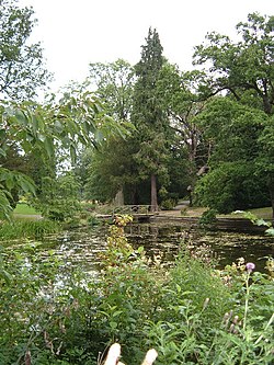
Thorp Perrow Arboretum
Thorp Perrow Arboretum is an 85-acre (34 ha) woodland garden arboretum near Bedale in North Yorkshire, England.

Old Malton
Old Malton is a village in the civil parish of Malton, in North Yorkshire, England. The village is situated just south of the A64 road and is 1-mile (1.5 km) north-east of the town of Malton. The village is on the B1257 which links Malton with the A64 and the A169 road to the north and is bounded on its eastern side by the River Derwent.