
 English
 Français

Locomotion Museum
Locomotion, previously known as Locomotion the National Railway Museum at Shildon, is a railway museum in Shildon, County Durham, England. The museum was renamed in 2017 when it became part of the Science Museum Group.

Manchester Hydraulic Power
Manchester's Hydraulic Power system was a public hydraulic power network supplying energy across the city of Manchester via a system of high-pressure water pipes from three pumping stations from 1894 until 1972. The system, which provided a cleaner and more compact alternative to steam engines, was used to power workshop machinery, lifts, cranes and a large number of cotton baling presses in warehouses as it was particularly useful for processes that required intermittent power. It was used to wind Manchester Town Hall clock, pump the organ at Manchester Cathedral and raise the safety curtain at Manchester Opera House in Quay Street. A large number of the lifts and baling presses that used the system had hydraulic packings manufactured by John Talent and Co.Ltd. who had a factory at Ashworth Street, just off the Bury New Rd. close to the Salford boundary.
Manchester Corporation opened its first pumping station in 1894, following pioneering schemes in Kingston upon Hull and London. The scheme was a success and additional pumping stations to cope with the demand for power were added in 1899 and 1909. Modernisation started in the 1920s, when the original steam pumps were replaced by electric motors at two pumping stations. The greatest volume of water was supplied in the 1920s, although the length of the water mains continued to increase until 1948. Usage started to decrease in the 1930s, and the first pumping station closed in 1939. By the 1960s, there were serious concerns about the state of some of the equipment and corrosion in the high-pressure mains, and in 1968 the corporation announced its intent to switch the system off, which it did at the end of 1972.
The grade II listed pumping station built in Baroque style at Water Street has a new life as part of the People's History Museum, while one of its pump sets has been restored and is displayed at the Museum of Science and Industry, where it is part of a larger display about hydraulic power.

Northumberland Street
Northumberland Street is a major shopping street in the city of Newcastle upon Tyne, in the North East of England. It is home to a wide range of different retailers, banks and cafes. As of 2004, Northumberland Street was the most expensive location in the UK outside London to own a shop, in terms of rental per square foot. However, by 2016, it had been overtaken by Manchester's Market Square, Leeds' Commercial Road, Edinburgh's Princes Street, and Glasgow's Buchanan Street. There are currently over 51 retailers including pubs on Newcastle's Northumberland Street.

Ponderosa (Sheffield)
The Ponderosa is a recreation area within the City of Sheffield, South Yorkshire, England. Although not a public park it was designated as Open Space by Sheffield City Council in the 1993 Unitary Development Plan. It covers an area of over 25 acres (10 ha) and is located at 53.3868°N 1.4865°W / 53.3868; -1.4865, 0.9 miles (1.5 km) west of the city centre between the districts of Upperthorpe and Netherthorpe. Although the name "Ponderosa" was originally an informal name given by local children, it is now the accepted title and is recognised by the local council. Along with Weston Park and Crookes Valley Park it is one of the three "Crookesmoor Parks".

Pease Dean
Pease Dean is a nature reserve at Pease Bay, in the Scottish Borders area of Scotland, near the Anglo-Scottish border and Cockburnspath, Cove, and Dunglass. OS 67 NT794707.
The reserve is managed by the Scottish Wildlife Trust and has two parts: Pease Burn and Tower Burn. Pease Burn is open grassland, with gorse and alder. Tower Burn consists of mixed woodland.

Saltmarket
The Saltmarket is a thoroughfare in the City of Glasgow, Scotland. It is a southward continuation of the High Street, running south from Glasgow Cross to the junction with Clyde Street and Crown Street by the River Clyde. It runs past the High Court of Glasgow and also Glasgow Green. Along with the High Street and Crown Street it forms part of the A8.

Fairfield railway station (England)
Fairfield railway station serves the Fairfield area of Droylsden, Tameside, Greater Manchester and is located 3.1 miles (5 km) east of Manchester Piccadilly station. It was opened by the Manchester, Sheffield & Lincolnshire Railway in 1892, when the Fallowfield Loop to Manchester Central opened; it replaced an earlier station that had opened on the line in 1841, west of the present site.

A1300 road
The A1300 is the main 'cross town' route in South Shields, Tyne and Wear. The road runs from Simonside to Marsden via Harton Nook. It is 3.7 miles (6 km) long.
Hill of Beath
Hill of Beath (( ; Scots: Hill o Beath) is a hill and a village in Fife, Scotland, just outside Dunfermline and joined to Cowdenbeath.
On 16 June 1670 the Hill of Beath was the location of a celebrated meeting of the Covenanters at which preachers John Blackadder and John Dickson officiated. It was described as "a great gathering of persons who came from the east of Fife and as far West as Stirling". At that conventicle, during the height of the struggle against episcopal rule, the Covenanters brought swords and pistols to defend themselves against attack.
The village at this location was built and owned by the Fife Coal Company, which rented the cottages to the miners for the duration of their employment in the mine. In 1896 the village population was about 1,300. As an experiment, a public house was started in June 1896 using the Gothenburg system, with any profits to be used for public works. An initial report suggested it was helping to reduce drunkenness despite the ease of access to public houses in nearby Crossgates.
In February 1901 an underground fire killed seven men.
Accidents, often fatal, were frequent in the years that followed.
Hill of Beath is the birthplace of Rangers F.C. legend Jim Baxter and Scotland captain Willie Cunningham and the home town of former Celtic F.C. captain Scott Brown. Football managers Dick Campbell and Ian Campbell were brought up in the village.
The village has a primary school and a community centre.

Stirling services
Stirling services is a motorway service station near Stirling, Scotland. The service station is located where the M9 motorway and M80 motorway join. It is owned by Moto.

Boon Keng
Boon Keng (Chinese: 文庆, Tamil: பூன் கெங்) is a subzone within the planning area of Kallang, Singapore, as defined by the Urban Redevelopment Authority (URA). The smallest in terms of physical area among the nine subzones that make up Kallang, Boon Keng is bounded by the Pelton Canal in the north; the Kallang–Paya Lebar Expressway (KPE) and Sims Way in the east; Sims Avenue in the south; and the Kallang River in the west.
Primarily a prime residential area, this area is served by Boon Keng MRT station along the North East Line and Kallang MRT station along the East–West Line. A plot of land at Lorong 3 Geylang is slated for future development into a new residential precinct. Geylang West Community Club is located within this subzone.
This area took its name from Dr Lim Boon Keng, a prominent figure in Singapore history.
All Saints Catholic School, York
All Saints Catholic School, York is a split site, coeducational comprehensive Catholic secondary school and sixth form. The school is regarded as the oldest Catholic school in England.
The school has a split site. The Upper Site is between South Bank and Scarcroft Road in the south side of York, England, and is where years 10–13 are taught. The Lower Site is on Nunnery Lane close to Micklegate Bar and is where years 7–9 are taught.
In 2022, it was announced that All Saints is the best school in York, fifth best School in the North.
The school has been serving the Catholic population of York and more broadly Yorkshire (in some form) since 1665, and plays a role in the Catholic education of the region as the only Catholic Secondary school and Sixth Form in York.
Venerable Bede Church of England Academy
The Venerable Bede Church of England Academy (formerly Venerable Bede Church of England (Aided) Secondary School) is a coeducational secondary school located in the Tunstall area of Ryhope, Sunderland, Tyne and Wear, England. The school is named after Saint Bede, a monk, author and scholar who wrote Historia ecclesiastica gentis Anglorum.
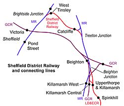
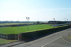
Catcliffe railway station
Catcliffe railway station is a former railway station in the Catcliffe area of Rotherham, South Yorkshire, England.
Sankey Valley Park
Sankey Valley Park is a public park in Warrington, Cheshire. It occupies part of the Sankey Valley and the main park itself covers over 1½ miles between Sankey Bridges in the south and Callands in the north. The valley follows the course of Sankey Brook and the now disused Sankey Canal. The park is enjoyed by walkers, cyclists and anglers and the central section of the park is family orientated with children's play features, a maze and lawned areas. Bewsey Old Hall sits on the edge of the central section of the park. The Trans Pennine Trail passes around 500 yards (460 m) from the southern tip of the park.

Gormire Lake
Gormire Lake is a natural lowland lake that lies at the foot of Whitestone Cliff, a western escarpment of the Hambleton Hills in the North York Moors National Park. The lake is 1.2 miles (2 km) east of the village of Sutton-under-Whitestonecliffe in North Yorkshire, England. Gormire has no inflow or major outflow of water. It is thought to be fed by an underground spring and drained by a limestone channel so the water finds a way out through the base of the cliff face to the east of the lake. The lake is also known as the White Mere, Lake Gormire, or more simply, Gormire. The name Gormire translates as filthy swamp.
The lake was formed over 20,000 years ago by glacial erosion. When an ice sheet pushed its way between the Pennines and the North York Moors, it bulldozed the soft earth away and carved the cliffs at Whitestone and in turn the mud left over stopped the water's egress and formed the glacial lake. Gormire Lake was a result of this process and is fourth largest of the natural lakes in Yorkshire (the other three being Hornsea Mere, Malham Tarn and Semerwater). The lake was first designated as an Site of Special Scientific Interest (SSSI) in 1954; however, in 1985 the area surrounding the lake was incorporated into the SSSI status with the new area being 133.5 acres (54.03 ha). The new designation incorporates the broadleaf woodlands of Garbutt Wood which encroach right up to the water's edge.
The lake is the setting of several myths; one being of a knight known as Sir Harry Scriven who conned the Abbot of Rievaulx Abbey into letting him ride his horse (a white mare, the so called derivation of White Mare Cliff (another name for Whitestonecliff)). The knight and the abbot rode on from an inn and as they did so, it turned into a race. The abbot then changed into the devil, which caused such panic in the knight that he couldn't stop the horse and himself plunging into Gormire Lake from the clifftop. The 'devil' was then seen to jump into the lake after them and the boiling effect of the devil in the water is what is said to have caused the darkness of the lake to this day.
Other myths are that the lake is bottomless, that the bottom of the lake is the entrance to hell, there is submerged village underneath the water and that a goose once disappeared in the lake to emerge in a well at Kirkbymoorside stripped of all its feathers.
Gormire Lake is popular with wild swimmers as it has no streams feeding it so there is very little current and the waters are described as being 'warm'. Swimmers have reported that it is seething with leeches. The Times named the lake as one of the 20 best lakes and rivers in Britain for wild swimming.
RAF Kirkbride
RAF Kirkbride, was a Second World War era airfield in the village of Kirkbride, Cumbria, England. Opened in June 1939, the base was intended to be an aircraft repair depot, as its location was deemed to be far enough away from the threat of enemy aircraft. After the Second World War, the site remained open as a maintenance unit and a disposal airfield for redundant aircraft. It was closed in 1960.
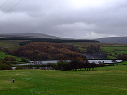
Swineshaw Reservoir (Derbyshire)
For the reservoirs near Stalybridge, in Tameside, Greater Manchester, see Higher Swineshaw Reservoir and Lower Swineshaw Reservoir
Swineshaw Reservoir is a reservoir near Glossop, north Derbyshire. In 1837, 50 local millowners and gentlemen, known as the "Glossop Commissioners", obtained an Act of Parliament to construct the Glossop Reservoirs. Hurst Reservoir was on the Hurst Brook and Mossy Lea Reservoir was to take water from the Shelf Brook. Only the Hurst reservoir was constructed before the money ran out. Mossy Lea Reservoir was constructed privately by the Duke of Norfolk. Swineshaw, on Swineshaw Clough, was adopted in 1864 by the Glossop Water Company to provide drinking water for Glossop. It was taken over in 1929 by the Glossop Corporation Waterworks. This became part of the Manchester Corporation Waterworks in 1959. Swineshaw, Hurst Reservoir and Mossy Lea Reservoir are no longer in service.
The Peak District Boundary Walk runs past the south side of the upper reservoir.

St John's Church, Langcliffe
St John's Church is the parish church of Langcliffe, a village in North Yorkshire, in England.
Until the 19th century, Langcliffe lay in the parish of Church of St Alkelda, Giggleswick. A church school was established in the village in the early years of the century, and it was used as a Sunday school, and occasionally for worship. A purpose-built church was designed by James Mallinson and Thomas Healey and was completed in 1851. It was grade II listed in 1988.
The church is built in stone with a slate roof. It consists of a nave, a south porch, and a chancel with a north vestry and boiler house. On the west gable end is an octagonal bell turret with a pyramidal head, and on the east gable is a cruciform finial. Inside, the timbers of the roof are visible, and wooden furnishings including the altar rail may be original.

Hutton Henry
Hutton Henry is a village in the civil parish of Hutton Henry and Station Town
, in County Durham, England, near Peterlee, Castle Eden and Wingate. The population of the parish at the 2011 census was 1,565. It is situated to the west of Hartlepool, near the villages of Wingate and Station Town. At the top of hills in Hutton Henry the sea, Blackhall Colliery, Castle Eden, Wingate, Peterlee and Shotton can be seen. On 1 February 2023 the parish was renamed from "Hutton Henry" to "Hutton Henry and Station Town".
In ca. 1050 the village was known as Hoton. Henry de Essh held it in the 14th century, providing the second part of the name. During the 19th century it was a mining village, as were the nearby villages of Wingate and Station Town. Its population increased from 156 in 1801 to 3,151 in 1891 due to the opening of collieries. Hutton Henry colliery was operational between 1876 and 1897 and was owned by Hutton Henry Coal Co. Ltd. In 1894 its average output was about 190,000 tons per annum, and it was said to employ 1,000 men and boys.