Ingleton railway station (London and North Western Railway)

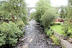
Ingleton (L&NW) railway station (also known as Ingleton Thornton station) was one of two stations serving the village of Ingleton, North Yorkshire, England. It owed its existence to the intense rivalry between the two stations' owners. It opened, along with the Ingleton Branch Line, in 1861, and closed in 1917, by which time the two railway companies had become more cooperative.

1. History

The "Little" North Western Railway's Ingleton station was originally opened in 1849 as a temporary terminus, but closed only ten months later as the company could not afford to continue the line beyond Ingleton. Eventually it was the Lancaster and Carlisle Railway (L&CR) that built the Ingleton Branch Line from the existing Ingleton Station to Low Gill. By the time the branch was completed in 1861, the L&CR was operated by the London and North Western Railway (L&NWR), and the NWR was operated by the rival Midland Railway (MR), and the L&NWR did everything in its power to frustrate the MR's ambition of using the new line as a main route to Scotland. Thus the L&NWR built Ingleton (L&NW) station at the other end of Ingleton Viaduct. The Ingleton Branch, and the L&NW station, opened on 16 September 1861. The MR reopened the original Ingleton station two weeks later but refused to let L&NW trains use it. Passengers had to walk a distance of almost 1 mile (1.6 km) between the two Ingleton stations, descending into the valley below and climbing up the other side, where they often had a long wait as the companies did not cooperate over timetabling either. By 1862, the MR agreed to allow L&NW trains to terminate at the Midland station, but both Ingleton stations remained open and connections were not timetabled. On the positive side, the presence of two stations allowed people to pay a penny fare to cross the viaduct between the two stations simply to enjoy the view. On 13 March 1893, a 1-mile (2 km) mineral line was opened from the L&NW station to Meal Bank Quarry. It passed over a high embankment and bridge across the entrance to the Ingleton Waterfalls Trail. The embankment survives to this day. The quarry and its line closed in 1909. The L&NW station closed on 1 January 1917. The other station survived until the line's closure in 1954. The L&NW station was demolished and the site is now used by a fuel supplier.

1. References


1. External links

Ingleton Viaduct: The North-West Frontier Archived 5 March 2014 at the Wayback Machine

Nearby Places View Menu
Location Image
249 m

Ingleton Waterfalls Trail

Ingleton Waterfalls Trail is a well-known circular trail beginning and ending in the village of Ingleton in the English county of North Yorkshire, now maintained by the Ingleton Scenery Company. It is claimed that the trail, some 8 kilometres (5 mi) long, and with a vertical rise of 169 m (554 feet) has some of the most spectacular waterfall and woodland scenery in the north of England. It is on private land and an entrance fee is charged.
Location Image
317 m

River Doe

The River Doe is a river in North Yorkshire, England. The river's source is near God's Bridge close to the settlement of Chapel-le-Dale and flows through Twisleton in a south-westerly direction to Ingleton, where it meets the River Twiss to form the River Greta. The river forms part of the River Lune system that flows into the Irish Sea.
Location Image
333 m

River Twiss

The River Twiss is a river in the county of Yorkshire, England. The source of the river is Kingsdale Beck, which rises at Kingsdale Head at the confluence of Back Gill and Long Gill in the Yorkshire Dales. Beneath Keld Head, the river changes its name to the River Twiss. It has two notable waterfalls, Thornton Force and Pecca Falls, and its course follows part of the Ingleton Waterfalls Walk, then through Swilla Glen to Thornton in Lonsdale and down to Ingleton, where it meets the River Doe to form the River Greta. The English landscape artist J. M. W. Turner was a frequent visitor to the area, and his sketch of Thornton Force in 1816 is currently part of the Tate collection.
Location Image
439 m

St Mary's Church, Ingleton

St Mary's Church is the parish church of Ingleton, North Yorkshire, a village in England. There was a church on the site by the 12th century. The oldest part of the current building is the tower, dating from the 15th century. Between 1886 and 1887 the remainder of the church was rebuilt, to a Decorated Gothic-style design, by Cornelius Sherlock. The building was grade II* listed in 1958. The church is built of stone with a slate roof, and consists of a nave with a clerestory, north and south aisles, a south porch, a chancel with a north vestry, and a west tower. The tower has three stages, diagonal buttresses, a west doorway with a pointed arch, a chamfered surround and a hood mould, above which is a three-light window, a south clock face, two-light bell openings, a string course, and an embattled parapet with corner finials. Inside, some fragments of wall painting survive, but the highlight is the 12th century font, described by Nikolaus Pevsner as "one of the best in the West Riding". It is cylindrical, and is carved with an arcade design, with fourteen Biblical scenes. It was rediscovered in the 18th century, cleaned and brought back into use in 1830, and mounted on its current base in 1858.