
 English
 Français

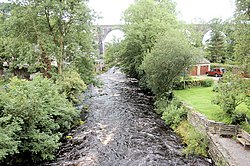
Ingleton Waterfalls Trail is a well-known circular trail beginning and ending in the village of Ingleton in the English county of North Yorkshire, now maintained by the Ingleton Scenery Company. It is claimed that the trail, some 8 kilometres (5 mi) long, and with a vertical rise of 169 m (554 feet) has some of the most spectacular waterfall and woodland scenery in the north of England. It is on private land and an entrance fee is charged.
1. Beginnings
Following a number of articles in the Lancaster Guardian and other newspapers about the scenery in and around Ingleton, public interest led to the creation of the trail in an area which was previously hidden from view. Paths and bridges were built and the trail opened on Good Friday, 11 April 1885. The presence of Ingleton railway station played a major role in the early success of the trail, attracting visitors from Bradford, Manchester and Leeds.
1. Geology
Ingleton lies on the North and South Craven fault, exposing Carboniferous and Ordovician rocks. The Ingletonian rock has been classified as Ordovician.
1. The walk
Starting in the Broadwood car park the trail takes walkers along the banks of the River Twiss, through Swilla Glenn with its coin embedded tree and on to Pecca Falls, Pecca Twin Falls, Holly Bush Spout and Thornton Force. A footbridge bridge crosses the Twiss and leads on to Twistleton Lane, which crosses out of the valley of the River Twiss at 285 metres (934 ft). Following Twistleton Lane down past Scar End Farm and Twistleton Hall the walk crosses Oddies Lane to Beezley's Farm.
Past Beezley's the trail starts its descent along the banks of the River Doe. This river emerges near God's Bridge close to the settlement of Chapel-le-Dale and flows gently until it reaches the waterfalls walk at Beezley's Falls Triple Spout (with its three waterfalls side-by side). As the trail continues, you look down 18 metres (59 feet) onto Rival Falls and then onto Baxenghyll Gorge, Snow Falls and finally walk through Twistleton Glen and back to Ingleton. In Ingleton, the Twiss and the Doe meet to form the River Greta, which in turn flows into the River Lune. English Nature designated the River Twiss and River Doe areas of the Waterfalls Trail as a Site of Special Scientific Interest (SSSI) due to the interesting plants and animals and the geological structures located there.
1. See also
List of waterfalls List of waterfalls in England
1. References
Bibliography CPGS (2003). "Ingleton Waterfalls trail" (PDF). Craven and Pendle Geological Society. Archived from the original (PDF) on 12 May 2013. Retrieved 5 March 2014.
1. External links
Ingleton Waterfalls Trail Lancaster Guardian Natural England Detailed Walk description on Car Free Walks
Nearby Places View Menu

River Doe
River Twiss
