
 English
 Français

Bury Knowsley Street railway station
Bury Knowsley Street was a railway station in Bury, Greater Manchester, England. It formerly served the town on the national railway network between 1848 and 1970.
Nearby Places View Menu
118 m
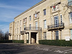
Bury Town Hall
Bury Town Hall is a municipal building in Knowsley Street, Bury, Greater Manchester, England. The town hall, which is the headquarters of Metropolitan Borough of Bury, is a locally listed building.

211 m
St Marie's Church, Bury
St Marie's Church is a Roman Catholic parish church in Bury, Greater Manchester, England. It was built from 1841 to 1842 in the Gothic Revival style. It is situated between the Manchester Road and Back Knowsley Street in the town centre. It is a Grade II listed building.
222 m
Bury College
Bury College is a further education college located within the Borough of Bury, in Greater Manchester, England. The college offers A-Levels, BTECs and diplomas.
244 m
Buckley Wells tram stop
Buckley Wells is a proposed tram stop on the Bury Line of Greater Manchester's Metrolink light rail system. It is to be between Bury Interchange and Radcliffe Metrolink station, in the Buckley Wells area of Bury, north of Fishpool and south of Bury town centre.
The proposed site of Buckley Wells stop, by the A56 road, is owned by Transport for Greater Manchester, was proposed in 2003, offering (in addition to the Metrolink stop and services for southern Bury) a park and ride facility, and opportunity to provide an interchange with the East Lancashire Railway.