
 English
 Français

St Marie's Church, Bury
St Marie's Church is a Roman Catholic parish church in Bury, Greater Manchester, England. It was built from 1841 to 1842 in the Gothic Revival style. It is situated between the Manchester Road and Back Knowsley Street in the town centre. It is a Grade II listed building.
Nearby Places View Menu

122 m
Lancashire Fusiliers War Memorial
The Lancashire Fusiliers War Memorial is a First World War memorial dedicated to members of the Lancashire Fusiliers killed in that conflict. Outside the Fusilier Museum in Bury, Greater Manchester, England, it was unveiled in 1922—on the seventh anniversary of the landing at Cape Helles, part of the Gallipoli Campaign in which the regiment suffered particularly heavy casualties. The memorial was designed by Sir Edwin Lutyens. He was commissioned in light of a family connection—his father and great uncle were officers in the Lancashire Fusiliers, a fact noted on a plaque nearby. He designed a tall, slender obelisk in Portland stone. The regiment's cap badge is carved near the top on the front and rear, surrounded by a laurel wreath. Further down are inscriptions containing the regiment's motto and a dedication. Two painted stone flags hang from the sides.
The memorial was unveiled by Lieutenant General Sir Henry de Beauvoir De Lisle on 25 April 1922, using the novel method of pressing an electric button. The remaining funds were spent on drums and bugles for the regiment and donated to the Lancashire Fusiliers' compassionate fund. After the Lancashire Fusiliers were amalgamated into the Royal Regiment of Fusiliers in 1968, the memorial was adopted by the new regiment and rededicated to all fusiliers killed in action. It originally sat outside the Lancashire Fusiliers' headquarters in Wellington Barracks but was relocated when the barracks closed in the 1970s. It was moved again in 2009, this time to sit in a public park renamed Gallipoli Gardens, outside the Fusilier Museum, which moved at the same time. The memorial was designated a Grade II listed building in 1992. It was upgraded to Grade II* in 2015 (on the centenary of the Cape Helles landing), along with two other memorials related to the Gallipoli Campaign; later that year it was recognised as part of a national collection of Lutyens' war memorials.
126 m
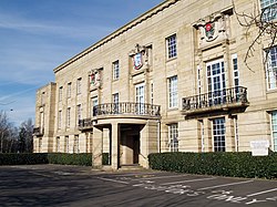
Bury Town Hall
Bury Town Hall is a municipal building in Knowsley Street, Bury, Greater Manchester, England. The town hall, which is the headquarters of Metropolitan Borough of Bury, is a locally listed building.

147 m
Bury Interchange
Bury Interchange is a transport hub in Bury town centre, Bury, consisting of a Metrolink tram stop, opened on 6 April 1992 after previously serving as a railway station from 1980 to 1991, and a bus station, opened on 17 March 1980.

191 m
Metropolitan Borough of Bury
The Metropolitan Borough of Bury is a metropolitan borough of Greater Manchester in England. It is north of Manchester, to the east of Bolton and west of Rochdale. The borough is centred around the town of Bury but also includes the other towns of Ramsbottom, Tottington, Radcliffe, Whitefield and Prestwich. Bury bounds the Lancashire districts of Rossendale and Blackburn with Darwen to the north. With a population of 198,921 in 2024, it is the smallest borough in Greater Manchester.
Within the boundaries of the historic county of Lancashire, the Metropolitan Borough of Bury, which covers 99 square kilometres (38 sq mi), was created on 1 April 1974, with the transfer of functions from the County Borough of Bury and the boroughs of Prestwich and Radcliffe, along with the urban districts of Tottington and Whitefield, and part of the urban district of Ramsbottom, all previously in Lancashire.