
 English
 Français

Newburgh, North Yorkshire
Newburgh is a village and civil parish located in the county of North Yorkshire, England. The population at the 2011 Census was less than 100. Details are maintained in the civil parish of Coxwold.
The village is mainly a large farming community, the main road passing through the village is 'Colley Broach Road'. Newburgh village leads directly into Newburgh Grange. The local schools and colleges are about 10 minutes drive away in either Ampleforth, Oulston or Thirsk.
From 1974 to 2023 it was part of the district of Hambleton, it is now administered by the unitary North Yorkshire Council.

Killinghall
Killinghall is a village and civil parish in the county of North Yorkshire, England. The civil parish population taken at the 2011 census was 4,132.
The village is situated approximately 3 miles (5 km) north of Harrogate, extending south from the bridges on the A61 road over the River Nidd. The undeveloped area between Killinghall and Harrogate is known as Killinghall Moor some of which has been developed into Jenny Fields Estate. The village of Ripley lies 1 mile (1.6 km) to the north and Hampsthwaite 2 miles (3.2 km) to the west. Killinghall's position on the A61 links the village to Harrogate and Ripon. Harrogate bus route 36 between Ripon, Harrogate and Leeds stops in Killinghall.
Until 1974 it was part of the West Riding of Yorkshire. From 1974 to 2023 it was part of the Borough of Harrogate, it is now administered by the unitary North Yorkshire Council.
Killinghall is primarily a commuter village, currently without a public house, the Three Horseshoes and the Greyhound pub have closed, with the former set for demolition and converted into a local convince store. Within the parish, but outside the village is one other: Old Spring Well - formerly the Travellers' Rest, with a second, The Nelson Inn, just outside the boundary, Killinghall CE Primary School, the Church of St Thomas, Killinghall Methodist Church, a children's day nursery, doctor's office and a garden centre with nursery. The local area incorporates a number of farms.

Firswood tram stop
Firswood is a tram stop on the South Manchester Line (SML) and Airport Line of Greater Manchester's light-rail Metrolink system. Located in the Firswood area of Stretford, it was built as part of Phase 3a of the network's expansion, and opened on 7 July 2011.
Firswood Metrolink station is located on a section of the former Cheshire Lines Committee railway line, in a cutting adjacent to St John Vianney School on Rye Bank Road. The stop provides access to both Firswood and Whalley Range.

Beinn Ìme
Beinn Ìme (Scottish Gaelic for 'Butter Mountain') is the highest mountain in the Arrochar Alps of Argyll, in the Southern Highlands of Scotland. It reaches 1,011 metres (3,317 ft), making it a Munro.
There are three usual routes of ascent. From Succoth, one may follow the same path that is used to reach The Cobbler before taking the right fork near the base of the Cobbler's main crags and continuing up the glen, across the bealach and up Ben Ìme's eastern ridge. Alternatively, the summit can be reached from the pass of Rest and be Thankful and from the Loch Lomond side, using the private road that leads to Loch Sloy.

A695 road
A695 road is a road in Northern England linking Newcastle upon Tyne, Tyne and Wear, with Hexham, Northumberland.

Viadux
Viadux is a mixed-use skyscraper complex under construction in the Castlefield area of Manchester, England. The first phase comprises a 40-storey residential tower that was completed in 2024. The second phase, approved in May 2025, includes the 246-metre (807 ft), 76-storey Nobu Manchester which will contain apartments and a 160-bed hotel, as well as a 23-storey residential building.
At 139 metres (456 ft), the first phase Viadux Building B2 is the 12th-tallest in Greater Manchester, as of December 2025. It was designed by SimpsonHaugh, who also designed the adjacent Beetham Tower, which was completed in 2006.

Nettleton, Lincolnshire
Nettleton is a village and civil parish in the West Lindsey district of Lincolnshire, England. It is situated less than 1 mile (1.6 km) south-west from the town of Caistor. At the 2001 census, the village had a population of 579.

Hoff, Cumbria
Hoff is a hamlet and civil parish in the unitary authority area of Westmorland and Furness and the ceremonial county of Cumbria, in England.
The hamlet of Hoff lies some 3 kilometres (1.9 mi) south-west of the town of Appleby-in-Westmorland. It consists of a number of a number of houses and a pub, The New Inn, which re-opened in 2011 after a number of years of closure. There is also a postbox and, formerly, a pioneering solar-powered lamppost. The name Hoff originates from old Norse and means 'a heathen sanctuary or temple'.
The civil parish of Hoff includes, as well as Hoff itself, the hamlets of Drybeck and Burrells. At the 2001 census the parish had a population of 189, decreasing to 164 at the 2011 Census.
There is no Church of England parish church in either the hamlet or civil parish of Hoff. Both are within the ecclesiastical parish of Appleby St Lawrence.
Hoff Beck forms on the southern border of the parish, with the confluence of Scale Beck and Asby Beck, and flows through both parish and hamlet. Between the confluence and Hoff hamlet, the beck flows over Rutter Force, a 30-foot (9.1 m) high waterfall.

Stadtmuller House
The Stadtmuller House, or F. D. Stadtmuller House, is a historic house built in 1880, and located in the Western Addition neighborhood of San Francisco, California. It is notable for its architecture.
The Stadtmuller House has been listed as a San Francisco Designated Landmark since December 5, 1970; a listed California Historical Landmark since July 19, 1976; and a National Register of Historic Places listed place since July 19, 1976.

Crossgates railway station (Fife)
Crossgates Fife railway station co-served the village of Crossgates, Fife, Scotland, from 1848 to 1949 on the Edinburgh and Northern Railway.

Ayr Racecourse
Ayr Racecourse at Whitletts Road, Ayr, Scotland, was opened in 1907. There are courses for flat and for National Hunt racing.

Brearton
Brearton is a village and civil parish in the county of North Yorkshire, England, situated about 3 miles (4.8 km) north of Knaresborough. The village is mentioned in the Domesday Book and its name derives from the Old English Brer-Tun, which means the town where the briars grew.
Until 1974 it was part of the West Riding of Yorkshire. From 1974 to 2023 it was part of the Borough of Harrogate, it is now administered by the unitary North Yorkshire Council.
According to the 2001 census it had a population of 141 increasing at the 2011 census to 146, however, in 2015, North Yorkshire County Council estimated the population to be 150. This small village has just over 40 houses that are situated quite close together. The fields surrounding the village show evidence of Medieval farming. Brearton is located at the end of the road from Nidd and Scotton; it is only accessible by vehicle from the west.
Whilst the village is popular for walkers, there are no shops, but there is one pub, The Malt Shovel, which The Guardian described as having "the best Sunday Lunches in Yorkshire."
St John's Church, Brearton was built in 1836.

Victoria Hospital for Sick Children, Kingston upon Hull
Victoria Hospital for Sick Children, previously known as the Hospital for Sick Poor Children, was a children's hospital in Kingston upon Hull which operated from 1874 until 1967. After it closed the building was renamed Victoria House and continued to be used for administrative purposes until 2020.
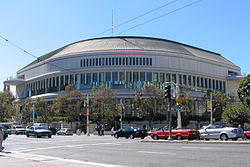
Louise M. Davies Symphony Hall
Louise M. Davies Symphony Hall is the concert hall component of the San Francisco War Memorial and Performing Arts Center in San Francisco, California. The 2,743-seat hall was completed in 1980 at a cost of US$28 million to give the San Francisco Symphony a permanent home.
Previously, the symphony shared the neighboring War Memorial Opera House with the San Francisco Opera and San Francisco Ballet. The construction of Davies Hall allowed the symphony to expand to a full-time, year-round schedule.

Bradford City A.F.C. Women
'Bradford City AFC Women' is an English women's football club which represents the city of Bradford, West Yorkshire. Founded in 1988, they currently play in the North East Regional Women's Football League Premier Division, and have competed in the Women's National League since promotion from the Northern Combination Women's Football League in 2013. Previously under the title of Bradford City Women's FC, the club announced its merger with Bradford City AFC in January 2021, through the Community Foundation, and has since adopted the name Bradford City AFC Women and Girls
After realigning the club with its former junior girls set up, Bradford City AFC Women has a player pathway from Under 9's through to Senior Football. A new Under 23's Development Team was launched for the 2021 - '22 season, with an aim of providing a stronger pathway for the young women of Bradford to play National League football.

Hadrian Road Metro station
Hadrian Road is a Tyne and Wear Metro station, serving the town of Wallsend, North Tyneside in Tyne and Wear, England. It joined the network on 14 November 1982, following the opening of the fourth phase of the network, between Tynemouth and St James via Wallsend.

Grimston, East Riding of Yorkshire
Grimston is a hamlet in the civil parish of East Garton, in the East Riding of Yorkshire, England, in an area known as Holderness. It is situated approximately 6 miles (9.7 km) north-west of Withernsea town centre.
Grimston lies east of the B1242 road near to the North Sea coast.
The name Grimston derives from the Old Norse personal name Grimr and the Old English tūn meaning 'settlement'.
To the north of the hamlet, on the coast, is an ancient moated site, dating from the 12th to 14th centuries, formerly the site of a fortified medieval manor house. It was the seat of the Grimston family until a fire in the mid-17th century.
The family then built a new manor house at Grimston Garth in 18th-century Gothic style. Grimston Garth lies south of the hamlet on a private road. The stable block at Grimston Garth was designated a Grade II* listed building in 1966 and is now recorded in the National Heritage List for England, maintained by Historic England.

Wellfield Academy
Wellfield Academy (formerly Wellfield High School) is a coeducational secondary school located in Leyland in the English county of Lancashire.
Wellfield High School was previously awarded specialist status as a Business and Enterprise College. Today, Wellfield Academy is a Community school administered by Lancashire County Council, however, while remaining a Community School, Wellfield Academy is currently being operated by the Endeavour Learning Trust, a multi-academy trust.
Wellfield Academy offers GCSEs as programmes of study for pupils.

Kirkton of Kingoldrum
Kirkton of Kingoldrum (Scottish Gaelic: Ceann Coilldruim) is a village in Angus, Scotland. It lies in approximately four miles (6 km) west of Kirriemuir on the B951 road.

Lornshill Academy
Lornshill Academy is a six-year comprehensive school situated in Alloa, Clackmannanshire, Scotland. Approximately 1049 pupils are enrolled with the school. Lornshill currently employs approximately 80 teachers and around 30 support staff. Lornshill is currently associated with seven primaries – Craigbank, Clackmannan, Banchory, Fishcross, Deerpark, Abercromby and Saint Serfs.