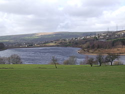
Valehouse (or Vale House) Reservoir is a man-made lake in Longdendale in north Derbyshire, England. It was built between 1865 and 1869 as part of the Longdendale Chain of reservoirs, which was built to supply water from the River Etherow to the urban areas of Greater Manchester, while maintaining a constant flow into the river. The upper reservoirs supply the drinking water, while Vale House and Bottoms are compensation reservoirs which guarantee the flow of water to water-powered mills downstream. Valehouse, with a crest elevation of 153 metres (502 ft), is too low to supply water under gravity to the Mottram Tunnel, so could not be used as an impounding reservoir. Today 45 megalitres of compensation water are released each day into the River Etherow.

Vale House Mill was purchased by Manchester Corporation in 1864, but a few villagers remained in the village of Vale House until 1868. In 1869 the hamlet was flooded out. The village was substantial, having an estimated population of 600 houses and 100 cottages. There was a gasworks and a school house for 24-30 scholars. Vale House Mill was the first spinning and weaving mill in Longdendale; it was built in 1775 by Samuel Oldknow. In 1864, it was owned by William Hobbs and Co. It had two carding rooms, nine spinning rooms, three weaving rooms and two Blowing Rooms. It had 15,416 spindles and 326 power looms. Vale House residents worshipped at the Ebenezer Methodist Chapel in Tintwistle (built in 1830), which was above the reservoir. The chimney at Vale House Mill survived the construction of the reservoir and became known as the "Whispering Chimney" as it produced ghostly noises during strong winds. It was demolished in 1887 at the request of the Manchester to Sheffield Railway Company, who feared for the stability of their trains when all the passengers crowded over to one side of a carriage to see the chimney protruding from the waters of the reservoir. The puddle trench was dug to a depth of 35 feet (11 m) to a layer of lower millstone grit, which rested on limestone shales, and a good watertight seal was easily achieved. It was stated in a statutory report, under the Reservoir Safety Act 1975, dated 12 June 1984, that all five reservoirs could be over-topped during a Probable Maximum Flood, so major works were undertaken. The retention level was raised by 3.81 m (12.5 ft), the embankment crest by 1.8 m (5 ft 11 in), and the wave wall was rebuilt. An 80-metre (260 ft) wide auxiliary spillway was constructed, two new 900-millimetre (35 in) butterfly valves installed and existing valves descaled and motorised. The 11 kV overhead powerline was routed in a new embankment crest duct.

Nearby Places View Menu
Location Image
1.2 km

Bottoms Reservoir (Derbyshire)

Bottoms Reservoir is a man-made lake in Longdendale in north Derbyshire, England. It was constructed between 1865 and 1877, by John Frederick Bateman as part of the Longdendale Chain of reservoirs to supply water from the River Etherow to the urban areas of Greater Manchester. The upper reservoirs supplied the drinking water, while Bottoms and Vale House reservoirs regulated the flow downstream for the benefit of local water-powered mills. The reservoir was obliged to release ten million gallons a day. To ensure this, a gauging basin 40 feet (12 m) in diameter was built. The drinking water flowed through the Mottram Tunnel to the Godley covered reservoir. The Peak District Boundary Walk runs along the south-western side of the reservoir and over the dam.
Location Image
1.3 km

Rhodeswood Reservoir

Rhodeswood Reservoir is a man-made lake in Longdendale in north Derbyshire, England. It was constructed by John Frederick Bateman between 1849 and June 1855 as part of the Longdendale Chain of reservoirs to supply water from the River Etherow to the urban areas of Greater Manchester. It is third in the chain, and it is from here that the water is extracted to pass through the Mottram Tunnel to Godley for Manchester. The Manchester Corporation Waterworks Act 1847 (10 & 11 Vict. c. cciii) gave permission for the construction of the Woodhead and Arnfield reservoirs; the Manchester Corporation Waterworks Act 1848 allowed the construction of Torside and Rhodeswood Reservoirs, and an aqueduct to convey the water to the Arnfield reservoir where it would pass through the Mottram Tunnel to Godley. During construction, landslips were a problem. On the night of 6 February 1852, 30 acres (120,000 m2) of land beneath the contractors' village of New Yarmouth moved 6 inches (150 mm) obliquely to the watercourse. Bateman consulted the engineers Robert Stephenson and Isambard Kingdom Brunel. Pipes were sunk to draw off the water from the underlying shale. The purest water in a reservoir lies between 1.5 and 3 metres (4 ft 11 in and 9 ft 10 in) beneath the water's surface, so water was extracted by means of syphons. The water now flows directly to the Arnfield Treatment Works in Tintwistle and to the Mottram Tunnel. A statutory report, prepared under the Reservoir Safety Act 1975 and dated 12 June, stated that all five reservoirs could be overtopped during a Probable Maximum Flood. Woodhead as the fountainhead would have the most extensive improvements, and with these completed there was no danger at Rhodeswood of overtopping; however, there was weakness in the north spillway. To reduce the pressure, the roadway was consolidated to protect the north spillway from erosion, the embankment was raised by 40 millimetres (1.6 in) above the road, the wave wall was heightened by 1.2 m (3 ft 11 in) and the south spillway tunnel was remodelled. The work took place between 1994 and 1995.
Location Image
1.7 km

Tintwistle Rural District

Tintwistle Rural District was a local government district in north east Cheshire, England from 1894 to 1974. It was created a rural district by the Local Government Act 1894 from the part of the Ashton-under-Lyne rural sanitary district which was in Cheshire. It consisted of the civil parishes of: Tintwistle Hattersley (until 1936) Matley (until 1936) Hattersley and Matley formed an exclave of the district. They were abolished in 1936 and their area transferred to the Municipal Borough of Hyde, the Municipal Borough of Dukinfield, Longdendale Urban District and the Municipal Borough of Stalybridge. In 1974 the district was abolished. At that time, much of north east Cheshire became part of Greater Manchester. Instead of becoming part of that county, or forming an exclave of Cheshire, Tintwistle became part of the High Peak district of Derbyshire.
1.7 km

Brosscroft

Peter Street and Brosscroft is an area in Derbyshire, England. It is part of Hadfield (where the population can be found), located on the north-east side. It is situated on the boundary of the Peak District National Park and as such is ideal for outdoor recreation activities including walking, cycling and watersports. It is within a stone's throw of the Park boundary, within two minutes walk (or cycle) of the Longdendale Trail and five minutes walk of the Trans Pennine Trail. The nearest of four linked reservoirs has been used for watersports in the summer, and the next reservoir has a resident sailing club. It is less than five minutes drive (ten minutes walk) to the railway station and a similar distance to the A628 trans-pennine trunk road. Residents thus enjoy a rural lifestyle but with the additional benefits of good east–west road links (to South Yorkshire/M1 and Manchester/M6) and a direct rail link to Manchester Piccadilly and thence to the Airport.