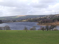
Bottoms Reservoir is a man-made lake in Longdendale in north Derbyshire, England. It was constructed between 1865 and 1877, by John Frederick Bateman as part of the Longdendale Chain of reservoirs to supply water from the River Etherow to the urban areas of Greater Manchester. The upper reservoirs supplied the drinking water, while Bottoms and Vale House reservoirs regulated the flow downstream for the benefit of local water-powered mills.

The reservoir was obliged to release ten million gallons a day. To ensure this, a gauging basin 40 feet (12 m) in diameter was built. The drinking water flowed through the Mottram Tunnel to the Godley covered reservoir. The Peak District Boundary Walk runs along the south-western side of the reservoir and over the dam.

Lieux à Proximité Voir Menu
514 m

Brosscroft

Peter Street and Brosscroft is an area in Derbyshire, England. It is part of Hadfield (where the population can be found), located on the north-east side. It is situated on the boundary of the Peak District National Park and as such is ideal for outdoor recreation activities including walking, cycling and watersports. It is within a stone's throw of the Park boundary, within two minutes walk (or cycle) of the Longdendale Trail and five minutes walk of the Trans Pennine Trail. The nearest of four linked reservoirs has been used for watersports in the summer, and the next reservoir has a resident sailing club. It is less than five minutes drive (ten minutes walk) to the railway station and a similar distance to the A628 trans-pennine trunk road. Residents thus enjoy a rural lifestyle but with the additional benefits of good east–west road links (to South Yorkshire/M1 and Manchester/M6) and a direct rail link to Manchester Piccadilly and thence to the Airport.
Location Image
775 m

Tintwistle Rural District

Tintwistle Rural District was a local government district in north east Cheshire, England from 1894 to 1974. It was created a rural district by the Local Government Act 1894 from the part of the Ashton-under-Lyne rural sanitary district which was in Cheshire. It consisted of the civil parishes of: Tintwistle Hattersley (until 1936) Matley (until 1936) Hattersley and Matley formed an exclave of the district. They were abolished in 1936 and their area transferred to the Municipal Borough of Hyde, the Municipal Borough of Dukinfield, Longdendale Urban District and the Municipal Borough of Stalybridge. In 1974 the district was abolished. At that time, much of north east Cheshire became part of Greater Manchester. Instead of becoming part of that county, or forming an exclave of Cheshire, Tintwistle became part of the High Peak district of Derbyshire.
Location Image
839 m

Tintwistle

Tintwistle ( TIN-səl) is a village and civil parish in the High Peak district of Derbyshire, England, which had a population of 1,400 at the 2011 census. The village is just north of Glossop at the lower end of Longdendale Valley. Tintwistle, like nearby Crowden and Woodhead, lies within the historic county boundaries of Cheshire.
Location Image
928 m

Hadfield railway station

Hadfield railway station serves the Peak District town of Hadfield, in Derbyshire, England. It is one of twin termini at the Derbyshire end of the Glossop Line; the other being Glossop. The station was opened by the Sheffield, Ashton-under-Lyne and Manchester Railway in 1844, as a stop on the Woodhead Line between Manchester Store Street and Sheffield Victoria. Hadfield is now the eastern terminus for local trains to/from Manchester Piccadilly.