
 English
 Français

Knotty Ash
Knotty Ash is an area of Liverpool, Merseyside, England, and a Liverpool City Council Ward, historically in Lancashire. The population at the 2001 Census was 13,200, increasing to 13,312 at the 2011 Census. Knotty Ash is well known as the home of comedian Sir Ken Dodd, who often mentioned it in his act.

Moss Side
Moss Side is an inner-city area of Manchester, England, 1.9 miles (3.1 km) south of the city centre. It had a population of 20,745 at the 2021 census. Moss Side is bounded by Hulme to the north, Chorlton-on-Medlock, Rusholme and Fallowfield to the east, Whalley Range to the south, and Old Trafford to the west.
As well as Whitworth Park and Alexandra Park, Moss Side is close to Manchester and Manchester Metropolitan universities. Manchester City Football Club played at Maine Road in Moss Side between 1923 and 2003.

Bulkeley
Bulkeley () is a village and former civil parish, now in the parish of Bulkeley and Ridley, in the unitary authority area of Cheshire East and the ceremonial county of Cheshire, England. The village is on the A534 road, 9 miles (14 km) west of Nantwich. In the 2011 census it had a population of 239.

Cockburn School
Cockburn School (formerly Cockburn High School) is a mixed secondary school located in the Beeston area of Leeds, West Yorkshire, England.
The original school on this site was Parkside secondary modern, which was an all-boys school. The headmaster for much of the time was Mr C Wadsworth.
It was previously a foundation school administered by Leeds City Council and The Learning Trust (South Leeds). The Learning trust also includes Beeston Primary School, Clapgate Primary School, Hugh Gaitskell Primary School, Lane End Primary School, Middleton Primary School, Middleton St Mary's CE Primary School, St Philip's RC Primary School and Westwood Primary School. However, Cockburn School was converted to academy status in February 2016. The school is now part of a multi-academy trust, and hopes that other schools within The Learning Trust (South Leeds) will convert to academy status and join the trust, whilst continuing to work closely with the partner schools.
Cockburn School offers GCSEs and BTECs as programmes of study for pupils. The school also has a specialism in the performing arts.

West Rounton
West Rounton is a village and civil parish in North Yorkshire, England. It is 8 miles (13 km) north of Northallerton. East Rounton is about 1-mile (1.6 km) away across the fields.
From 1974 to 2023 it was part of the district of Hambleton, it is now administered by the unitary North Yorkshire Council.

Throapham
Throapham is a hamlet in the civil parish of Dinnington St John's, in the Rotherham district, in the county of South Yorkshire, England.
Throapham was historically a township in the ancient parish of St John's in the West Riding of Yorkshire. St John's parish church, a Grade I listed building, was in the neighbouring parish-town of St John's, a very small place, and the two places formed a single township known as St Johns with Throapham. In 1866 St Johns with Throapham became a civil parish, as did Letwell, the other township in the ancient parish. In 1954 the civil parish of St Johns with Throapham was abolished and merged with the civil parish of Dinnington to form the new civil parish of Dinnington St John's.
In 1974 Throapham was transferred to the new county of South Yorkshire.

Bracken Hall Countryside Centre and Museum
Bracken Hall Countryside Centre and Museum is a children's museum, natural history education centre and nature centre established in 1989 at Bracken Hall on the edge of Baildon Moor, close to Shipley Glen in West Yorkshire, England.
In 2013 the Bradford Council removed their funding of the museum. The Friends of Bracken Hall worked to gather support in order to reopen the museum, and whilst the centre was planned to re-open in late 2015, it was finally re-opened to the public in April 2016 with the help of Baildon Town Council.

Commercial Cable Company Building
The Commercial Cable Company Building was an early skyscraper at 20–24 Broad Street Extension in Manhattan, New York City. Built for the Commercial Cable Company, it started construction in 1896 and was completed in 1897. It was designed by Harding & Gooch. Its height was 92.7 m (304 ft) and it was 22 stories tall. The building, like many of its contemporaries, was built in a historicist style, richly decorated. Two domes were designed on top.
The building adjoined the New York Stock Exchange. The Exchange leased the western portions of the first three floors in 1926, which were remodeled to include an trading floor.
It stood for half a century and was demolished in 1954. A 27-story modern office building was built in its place.
Holy Trinity Catholic and Church of England School
Holy Trinity Catholic and Church of England School is a coeducational all-through school for pupils aged from 3 to 16. The school is under the joint jurisdiction of the Roman Catholic Diocese of Hallam and the Church of England Diocese of Leeds. The school is located in Carlton Road, Barnsley, South Yorkshire, England. Holy Trinity is the only purpose built 3-16 Catholic and Church of England school in the country.
The school was formed in 2012 from the merger of St Michaels Catholic and Church of England High School, Holy Cross Deanery Church of England Primary School and St Dominic's Catholic Primary School. The school opened in a new building on land adjacent to the old High School site.
Simon Barber was the headteacher of Holy Trinity at its opening. He left on 15 July 2016, leaving the school to be run by deputy headteacher Anna Dickson, for Academic Year 2016–17. Dickson was then appointed as headteacher. She retired in August 2020.
After a critical Ofsted inspection, in January 2017 the school was put into in special measures. This led to the school being converted into an academy in May 2018. It is part of the St Claire Catholic multi-academy trust.
In September 2020 Lissa Oldcorn was appointed acting headteacher. In February 2022 she was appointed as permanent headteacher.

Yoker railway station
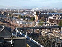
Yoker railway station serves the district of Yoker, Scotland.
The station is served by ScotRail as part of the SPT network, on the Argyle and
North Clyde Lines.
It is the nearest railway station to the Renfrew Ferry, and also the closest to the recently opened Renfrew Bridge on the north bank of the River Clyde.
The large Yoker Traction Maintenance Depot, which looks after the EMU fleet used on North Clyde suburban services, is a short distance to the east, towards Garscadden. Yoker IECC is also nearby - this has controlled the signalling on the entire North Clyde network since established by British Rail in 1989.

Trent Vale
Trent Vale is a suburb of Stoke-on-Trent, Staffordshire, England, bordered on the south by Hanford, to the west by Clayton, to the north by Newcastle-under-Lyme, to the southeast by Oakhill and Penkhull to the northeast. The Springfields and Trent Vale ward population at the 2011 census was 6,816.
The area is home to the Clayton Wood Training Ground, owned by Stoke City FC. Employment is provided locally by the Royal Stoke University Hospital.
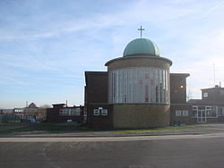
St. John the Evangelist Church was erected in the early Gothic style in 1843. The architect was Philip Wooton.
The A34 road runs from north to south through the centre of Trent Vale.

Whirlow Hall Farm
Whirlow Hall Farm is a working farm situated on Broad Elms Lane at Whirlow in the City of Sheffield, England. Since 1979 it has been the site of the Whirlow Hall Farm Trust, a registered charity which allows children and young people to visit a working farm. The site includes various Grade II listed buildings including Whirlow Farmhouse built on the site of the old Whirlow Hall. In the yard below the farmhouse is Whirlow Hall Cottage (sometimes called Low House) along with two ancient cruck barns and a cow shed.

European Energy Centre
The European Energy Centre (EEC) Institute is an independent professional educational body for the renewable energy, energy efficiency and electric vehicles sectors. The EEC along with the affiliated Centro Studi Galileo runs a biennial European Conference on renewable energy, heating and cooling applications. EEC's focus is on renewable energy education, training and conferences to help develop a workforce capable of designing, installing, repairing and maintaining renewable energy equipment and managing renewable energy projects.
The European Energy Centre and Centro Studi Galileo work with the United Nations Environment Programme (UNEP) the Intergovernmental International Institute of Refrigeration and Centro Studi Galileo, along with Universities such as Edinburgh Napier University and Heriot-Watt University in promoting the use of renewable energy technologies across the United Kingdom.
The European Energy Centre is also active European-wide with conferences in refrigeration, air conditioning and renewable energy, specifically Heating and Cooling technologies, see the 14th European Conference at Heriot-Watt University, Edinburgh.
The training activities of the European Energy Centre, the European Centre of Technology, and its parent company Centro Studi Galileo are promoted through partners.
The European Energy Centre is also active in India with training courses and conferences with its Indian Partner TERRE Policy Centre.
Motherwell
Motherwell (Scots: Mitherwall, Scottish Gaelic: Tobar na Màthar) is a town and former burgh in North Lanarkshire, Scotland, around 12 miles (19 km) south east of Glasgow. It has a population of around 32,120. Historically in the parish of Dalziel and part of Lanarkshire, Motherwell is the headquarters for North Lanarkshire Council. Geographically the River Clyde separates Motherwell from Hamilton to the west whereas the South Calder Water separates Motherwell from Carfin to the north-east and New Stevenston and Bellshill towards the north.
Motherwell is also geographically attached to Wishaw and the two towns form a large urban area in North Lanarkshire, with both towns having similar populations and strong community ties.

St Dunstans railway station
St Dunstans railway station is a closed station in the city of Bradford, West Yorkshire, England. The station was the location of a three-way junction with platforms on two of the lines.

Todmorden bus station
Todmorden bus station serves the town of Todmorden, West Yorkshire, England. The bus station is owned and managed by West Yorkshire Metro and was opened during 1997. The bus situated in the town centre, next to the Todmorden Market. The bus station can be accessed from Burnley Road below the rail viaduct.
The station consists of five stands, and is used by First West Yorkshire, TLC Travel and Rosso who operate services to areas around Todmorden and to the towns of Bacup, Burnley, Halifax, Hebden Bridge, Littleborough, Rawtenstall, Rochdale and Walsden. TLC Travel operate the local minibuses as of 26 January 2014.
The former Borough of Todmorden was only the second municipality in the British Isles to run motor buses, the service having commenced on 1 January 1907.

Ropner Park
Ropner Park is a free public park, located in Stockton-on-Tees, County Durham, England.
In June 1890 Major Robert Ropner offered a piece of land, known locally as Hartburn Fields to the people of Stockton which could be used as a public park, providing the local council would lay it out 'tastefully' and ‘keep it forever’. On 4 October 1893, Ropner Park was officially opened by the then Duke & Duchess of York. The ceremony involved the royals using an ornate key to open the Golden Gates.
After a century of regular use by the people of Stockton, the park was refurbished and renovated to its former glory between 2004 and 2007 by Stockton Borough Council, thanks to a £2.65m grant from the Heritage Lottery Fund. The Park is a roughly square site, with 20th-century railings along its road boundaries and is typically Victorian in style, with rockeries and floral displays. It has a tree-lined avenue which leads to an ornamental fountain and a pavilion with a veranda and also includes a new bandstand, based on the original design, a park ranger's office, bowling green, quoits green, tennis courts and a cafe, (run by the local charity, The Friends of Ropner Park). A large lake with islands dominates the lower part of the park and offers sanctuary to various species of water fowl and fish.
Seasonal fairs and occasional organised events are staged at the park throughout the year and various bands feature most Sunday afternoons during the summer months.

Bukit Brown MRT station
Bukit Brown MRT station is a future underground Mass Rapid Transit (MRT) station on the Circle Line (CCL), located in Novena planning area, Singapore. Announced along with the 17 stations of CCL Stages 4 and 5 in November 2005, it was designated as a station to be opened in the future. This station is currently non-operational due to the lack of development and demand in the area, although there are structural provisions set for the station’s future construction. Jalan Mashhor serves the station facilities on the ground level.
Newcastle Racecourse
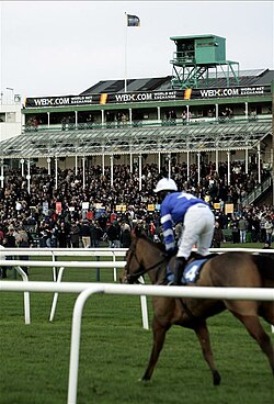
Newcastle Racecourse is a horse racing course located at Gosforth Park in Newcastle upon Tyne, England, owned by Arena Racing Company. It stages both flat and National Hunt racing, with its biggest meeting being the Northumberland Plate held annually in June.

Barugh, South Yorkshire
Barugh is a village in the metropolitan borough of Barnsley in South Yorkshire, England. The village falls within the Barnsley Metropolitan ward of Darton West. Until 1974 it was in the West Riding of Yorkshire.