
 English
 Français

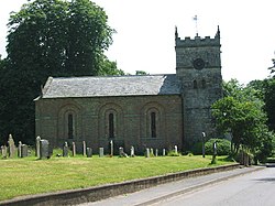
Holme-on-Spalding-Moor
Holme-on-Spalding-Moor est une paroisse civile et un village du Yorkshire de l'Est, en Angleterre.
1. Notes et références
(en) Cet article est partiellement ou en totalité issu de l’article de Wikipédia en anglais intitulé « Holme-on-Spalding-Moor » (voir la liste des auteurs).
1. Liens externes
Ressource relative à la géographie : Open Domesday
Portail du Yorkshire
Nearby Places View Menu

815 m
Holme Moor railway station
Holme Moor railway station was a station on the Selby to Driffield Line in the East Riding of Yorkshire, England serving the village of Holme-on-Spalding-Moor. It opened as Holme (Yorks) on 1 August 1848 and was renamed Holme Moor on 1 July 1923. It closed on 20 September 1954.

3.7 km
Seaton Ross
Seaton Ross is a village and civil parish in the East Riding of Yorkshire, England. It is situated approximately 6 miles (9.7 km) west of the market town of Market Weighton and 3 miles (4.8 km) north-west of the village of Holme-on-Spalding-Moor. It lies to the south of the A1079 road and north of the A163 road.
According to the 2011 UK census, Seaton Ross parish had a population of 565, an increase on the 2001 UK census figure of 545.
3.9 km
Everingham
Everingham is a village in the East Riding of Yorkshire, England. It is 5 miles (8 km) west of Market Weighton town centre and 4 miles (6 km) south of Pocklington town centre.
The village lies in a civil parish also officially called "Everingham" by the Office for National Statistics, although the county council and parish council refer to it as Everingham and Harswell since the parish also includes the nearby village of Harswell. According to the 2011 UK census, it had a population of 304, a decrease on the 2001 UK census figure of 320, and covers an area of 1,662.03 hectares (4,107.0 acres).

4.1 km
RAF Holme-on-Spalding Moor
RAF Holme-on-Spalding Moor, or more simply RAF Holme is a former Royal Air Force station located in Holme-on-Spalding-Moor, East Riding of Yorkshire, England.
The site was built during the Second World War, it was used during the war by the Royal Air Force (RAF) as a bomber station, and after the war as a transport airfield and bomb store before being "mothballed". In the 1950s, the RAF used the station as a training camp before it was transferred to the United States Air Force (USAF) as a reserve station during the Cold War. After USAF use, it became a testing airfield for Blackburn Aircraft and its successor British Aerospace until 1983, when the airfield was closed. Many of the airfield buildings survive as an industrial estate, but most of the runways have been demolished.
4.5 km
Spalding Moor
Spalding Moor is a moor (in the sense of an area of low lying wetland) in the East Riding of Yorkshire in England. It lies between the River Derwent and the town of Market Weighton at the edge of the Yorkshire Wolds. It forms part of the Humberhead Levels, south and east of the Escrick glacial moraine at the southern edge of the Vale of York.
The name is recorded in 1172 as Spaldinghemore. The name may refer to a river named Spalding, derived from the Old English spald "ditch or fenland river", which also gave its name to the village of Spaldington. The River Spalding is not recorded, but would be the river now known as the River Foulness. The name may also be derived from the tribe known as the Spalda mentioned in the 7th century Tribal Hidage, which gave rise to the tribe or district known as the Spaldingas, the "dwellers by the Spald". If that explanation is correct, Spald could refer to some other fenland river or rivers. The Spaldingas also gave their name to the town of Spalding in Lincolnshire.
As the moor was drained and cultivated, the name fell out of general use, but lives on in the name of Holme-on-Spalding-Moor. The village of Thornton was sometimes distinguished by the suffix "in Spalding Moor". The name of Barmby Moor, until 1935 formally known as Barmby on the Moor, also refers to Spalding Moor.