
 English
 Français
Everingham
Everingham is a village in the East Riding of Yorkshire, England. It is 5 miles (8 km) west of Market Weighton town centre and 4 miles (6 km) south of Pocklington town centre. The village lies in a civil parish also officially called "Everingham" by the Office for National Statistics, although the county council and parish council refer to it as Everingham and Harswell since the parish also includes the nearby village of Harswell. According to the 2011 UK census, it had a population of 304, a decrease on the 2001 UK census figure of 320, and covers an area of 1,662.03 hectares (4,107.0 acres).
Nearby Places View Menu

2.5 km
Seaton Ross
Seaton Ross is a village and civil parish in the East Riding of Yorkshire, England. It is situated approximately 6 miles (9.7 km) west of the market town of Market Weighton and 3 miles (4.8 km) north-west of the village of Holme-on-Spalding-Moor. It lies to the south of the A1079 road and north of the A163 road.
According to the 2011 UK census, Seaton Ross parish had a population of 565, an increase on the 2001 UK census figure of 545.

3.5 km
Holme Moor railway station
Holme Moor railway station was a station on the Selby to Driffield Line in the East Riding of Yorkshire, England serving the village of Holme-on-Spalding-Moor. It opened as Holme (Yorks) on 1 August 1848 and was renamed Holme Moor on 1 July 1923. It closed on 20 September 1954.

3.7 km
Hayton, East Riding of Yorkshire
Hayton is a village and civil parish in the East Riding of Yorkshire, England. It is situated approximately 2 miles (3 km) south of the market town of Pocklington and 4.5 miles (7 km) north-west of the market town of Market Weighton. It lies on the A1079 road.
The parish includes Burnby together with the hamlet of Thorpe le Street. The parish covers an area of 1,729.333 hectares (4,273.27 acres), According to the 2011 UK census and the parish had a population of 360, an increase on the 2001 UK census figure of 317. Although the civil parish is called "Hayton" its parish council is called "Hayton and Burnby Parish Council". On 1 April 1935 Burnby and Thorpe le Street parish was abolished and merged with Hayton.
The name Hayton derives from the Old English hēgtūn meaning 'hay settlement'.
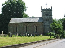
The church dedicated to St Martin was designated a Grade I listed building in 1967 and is now recorded in the National Heritage List for England, maintained by Historic England.
In 1823 Hayton was a village and a civil parish in the Wapentake of Harthill. The ecclesiastical parish was Hayton-cum-Beilby, with the parish incumbent living under the patronage of the Dean of York. Population at the time was 177. Occupations included twelve farmers, a blacksmith, a wheelwright, a corn miller, a shoemaker, and the landlord of The White Horse public house.

3.7 km
Thorpe le Street
Thorpe le Street is a hamlet and former civil parish, now in the parish of Hayton, in the East Riding of Yorkshire, England.