Guéliz (arabe : گليز ; berbère : ⴳⵉⵍⵉⵣ) est un des 5 arrondissements de Marrakech, au sein de la préfecture de Marrakech, dans la région Marrakech-Safi.
En 2014, la population de l'arrondissement s'élève à 188 333 habitants.
Depuis les élections communales de 2021, le Président de l'arrondissement est Omar Essalki (عمر السلكي)[réf. souhaitée].

1. Origine du nom

Le nom du quartier est emprunté à celui de Jbel Gueliz, la colline qui délimite au nord-ouest le quartier, occupée depuis le protectorat par une base militaire. Le nom de la colline est sans doute une déformation du terme berbère Igiliz, nom que portait la montagne foyer du mouvement almohade dans l'Anti-Atlas. Ce nom est ancien puisqu'il est déjà attesté au XIIe siècle lorsqu'Abu al-Abbas as-Sabti y effectue une retraite spirituelle.

1. Histoire

Guéliz est le quartier le plus ancien de la ville nouvelle de Marrakech. Protégé par la base militaire du Jbel Gueliz, la ville nouvelle est dessinée en 1913 par Henri Prost, qui jouit de toute la confiance du résident général Hubert Lyautey. L'axe principal du quartier est l'avenue Charles Mangin, qui relie la Koutoubia au Jbel Gueliz, renommée en 1957 avenue Mohammed V. Sous le protectorat est édictée une charte urbanistique stricte fixant la hauteur maximale des immeubles à 3 étages et imposant aux bâtiments la couleur ocre qui vaut aujourd'hui à Marrakech son surnom. Le quartier est pendant le protectorat principalement habité par les familles françaises et européennes. Dans le quartier prédominaient les villas familiales. En 1919, le quartier ne comptait que 870 habitants. Depuis le début des années 2000, le quartier connaît une transformation accélérée. La quasi-totalité des villas coloniales ont été transformées en immeubles. Le marché de Gueliz historique a été démoli et remplacé par le centre commercial Carré Eden, inauguré en 2014 tandis que place du 16 novembre, à l'angle des avenues Mohammed V et Hassan II, une autre zone commerciale, le Marrakech Plaza, a été ouverte en 2007. A l'extrémité occidentale du quartier, la nouvelle gare de Marrakech a été inaugurée en 2008.

1. Lieux remarquables

L'axe principal du quartier est l'avenue Mohammed V reliant la Koutoubia à la place Bir Anzarane. Il réunit la plupart des grandes enseignes commerciales du quartier. A l'angle avec le boulevard Zertouni, deux cafés emblématiques de la ville datent de l'époque coloniale : les Négociants et la Renaissance. Entre les rues Sourya et Liberté, le Carré Eden a remplacé en 2014 le marché historique du quartier. Place du 11 novembre, le Marrakech Plaza fait face à la Poste centrale et au siège régional de Maroc Telecom. En progressant vers Bab Nokb, à l'angle avec l'avenue Moulay Hassan, la place de la Liberté est connue localement pour sa fontaine, sous le nom de "Place Berdaï". Un autre axe important du quartier est l'avenue Hassan II, reliant Bab Doukkala à la gare. Face à la gare, le Théâtre royal est un bâtiment iconique de la ville nouvelle. Boulevard Zertouni, le cinéma Colisée est le cinéma historique de la ville nouvelle, où se tient chaque année le Festival international du film de Marrakech. A l'autre extrémité du boulevard, là où le boulevard Zertouni devient le boulevard Yaqub al-Mansur, se trouve la synagogue Henri Cadoch et le centre culturel américain. Rue Imam Ali se trouve l'Église des Saints-Martyrs de Marrakech.

1. Démographie de l'arrondissement

Cet arrondissement a connu, de 1994 à 2004 (recensements successifs), une hausse de population, passant de 148 305 habitants à 173 101 habitants. En 2014, la population de l'arrondissement s'élève à 188 333 habitants[réf. nécessaire].
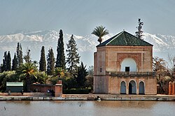
1. Galerie photo


1. Notes et références

Portail de Marrakech

Nearby Places View Menu
Location Image
272 m

Battle of Marrakesh

The Battle of Marrakesh was a central battle in the Hafidiya, in which Abd al-Hafid seized power from his brother Abd al-Aziz, fought outside Marrakesh, Morocco on 19 August 1908. A battalion led by Abd al-Aziz departed from Rabat and was ambushed and defeated on its approach to Marrakesh by forces loyal to Abd al-Hafid.
Location Image
272 m

Marrakesh

Marrakesh or Marrakech (; Arabic: مراكش, romanized: murrākuš, pronounced [murraːkuʃ]) is the fourth-largest city in Morocco. It is one of the four imperial cities of Morocco and is the capital of the Marrakesh-Safi region. The city lies west of the foothills of the Atlas Mountains. The city was founded circa 1070 by Abu Bakr ibn Umar as the capital of the Almoravid dynasty. The Almoravids established the first major structures in the city and shaped its layout for centuries to come. The red walls of the city, built by Ali ibn Yusuf in 1122–1123, and various buildings constructed in red sandstone afterwards, have given the city the nickname of the "Red City" or "Ochre City". Marrakesh grew rapidly and established itself as a cultural, religious, and trading centre for the Maghreb. After a period of decline, Marrakesh regained its status in the early 16th century as the capital of the Saadian dynasty, with sultans Abdallah al-Ghalib and Ahmad al-Mansur embellishing the city with an array of sumptuous monuments. Beginning in the 17th century, the city became popular among Sufi pilgrims for its seven patron saints who are buried here. In 1912, the French Protectorate in Morocco was established and T'hami El Glaoui became Pasha of Marrakesh and generally held this position until the independence of Morocco and the reestablishment of the monarchy in 1956. Marrakesh comprises an old fortified city packed with vendors and their stalls. This medina quarter is a UNESCO World Heritage Site and contains the Jemaa el-Fnaa square, a large number of souks (markets), the Kutubiyya Mosque, and many other historic and cultural sites. The city serves as a major economic centre and tourist destination. Property and hotel development in Marrakesh have grown dramatically in the 21st century. Marrakesh is particularly popular with the French, and numerous French celebrities own property in the city. Marrakesh is served by Marrakesh Menara Airport and by Marrakesh railway station, which connects the city to Casablanca and northern Morocco. Marrakesh has several universities and schools, including Cadi Ayyad University. A number of Moroccan football clubs are based here, including Najm de Marrakech, KAC Marrakech, Mouloudia de Marrakech and Chez Ali Club de Marrakech. The Marrakesh Street Circuit hosts the World Touring Car Championship, Auto GP and FIA Formula Two Championship races.
Location Image
531 m

El Harti Stadium

El Harti Stadium (Arabic: ملعب الحارثي) is a multi-use stadium in Marrakesh, Morocco. It is used mostly for football matches and athletics and hosted the home games of Kawkab Marrakech. The stadium holds 10,000 people. It was replaced by Stade de Marrakech in 2012.
Location Image
857 m

Marrakesh Railway Station

The Marrakesh Railway Station (Arabic: محطة قطار مراكش) is a railway station in Marrakesh, Morocco; it is currently the southern end-point of the Moroccan railway system. The current station was opened on August 10, 2008. From Marrakesh there is a direct rail link to Casablanca and Fez. Station Casablanca Voyageurs offers connections to Tangier or Oujda.
Location Image
893 m

Amal Women's Training Center and Moroccan Restaurant

Amal Women's Training Center and Moroccan Restaurant (Arabic: جمعية الامل لفنون الطبخ; French: Association Amal pour les Arts culinaires en faveur des femmes nécessiteuses) is a non-profit organization in Marrakesh, Morocco, that helps disadvantaged women gain work experience by training them in the preparation of Moroccan food and international food. The center was established in 2012 by Nora Belahcen Fitzgerald. Each year between 30 and 40 women complete four to six months of training, which often leads to them finding employment in a relevant field.