
 English
 Français

Whitfield, Derbyshire
Whitfield is a hamlet and former parish in Derbyshire, England. It is half a mile (1km) south of Glossop Town Hall, south of Glossop Brook between Bray Clough and Hurst Brook. Whitfield was one of the original townships in the ancient Parish of Glossop. Up to the latter part of the 18th century the hamlet was devoted mostly to agriculture with an area of 2,608 statute acres.
Nearby Places View Menu

173 m
Old Glossop
Old Glossop is a village and the original part of the town of Glossop in the High Peak area of Derbyshire, England, about 15 miles (24 km) east of Manchester and 23 miles (37 km) west of Sheffield. The village is on the very edge of the Peak District national park. The town centre was originally this village, but it migrated to the west with the Industrial Revolution and the building of a planned mill town (originally called Howard Town or New Glossop) and the railway from Manchester to Sheffield and its branch to Glossop railway station just north of Norfolk Square.
Although High Peak Borough Council has now called a large area of Glossop "Old Glossop" for political ward reasons, the original parish boundaries cover an area with a population of about 1,100.
At the beginning of the 1900s the village had eight pubs, but there are now only three: the Bull's Head, the Wheatsheaf and the Queen's Arms Hotel. In addition, a microbrewery, Howard Town Brewery, is located in Old Glossop.
In 2013, Old Glossop was used for filming in the BBC drama series The Village, starring John Simm and Maxine Peake. The parish church of All Saints and the former Duke of Norfolk school building appeared in the series.

196 m
The Crown Inn, Glossop
The Crown Inn is a public house at 142 Victoria Street, Glossop, Derbyshire SK13 8JF.
It is on the Campaign for Real Ale's National Inventory of Historic Pub Interiors.
It was built in the 1840s.

261 m
St James' Church Glossop
St. James's Church is an Anglican church in the evangelical tradition in the town of Glossop, Derbyshire, in the north-west of England. Along with St. Luke's Church, it makes up Whitfield Parish within Derby Diocese.
The churchyard contains war graves of three soldiers of World War I, and a Grade II listed memorial to Samuel Wood, a local mill-owner.
284 m
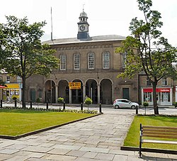
Glossop Town Hall
Glossop Town Hall, Market Hall, and Municipal Buildings is a complex in the centre of Glossop, Derbyshire, providing offices for High Peak Borough Council, a retail arcade, and covered market. The Town Hall was constructed in 1838 and significantly extended and altered in 1845, 1897 and 1923. The Town Hall building was designed by Weightman and Hadfield of Sheffield for the 12th Duke of Norfolk. It is constructed from millstone grit ashlar and topped with a distinctive circular cupola and clock. It is Grade II listed, forming a group with the market and Municipal Buildings to the south, and rows of shops to High Street West either side which were also part of Hadfield's design, and which marked the transition of Howard Town from a satellite industrial village to a freestanding urban entity.
It lies in the Norfolk Square Conservation Area which includes a number of other listed buildings around the square. The main elevation, intact with many surviving architectural details, forms an important part of the composition of the historic Norfolk Square. A blue plaque was erected by Glossop Heritage Trust in 2015 to commemorate its architect Matthew Ellison Hadfield and his contribution to the area.