
 English
 Français

Northenden
Northenden est une ancienne paroisse du Nord-Ouest de l'Angleterre, aujourd'hui incluse dans les limites de la ville de Manchester dont elle forme une banlieue. Elle se trouve sur la rive sud de la Mersey et de l'autoroute M60, 6,8 km à l'ouest de Stockport et 8,4 km au sud du centre ville de Manchester. Northenden est bordé par les districts de Didsbury, Gatley et Wythenshawe, respectivement au nord, à l'est et au sud-ouest. Elle se trouve dans le district de Wythenshawe.
1. Notes et références


1. Liens externes
Ressource relative à la géographie : Open Domesday
Portail de Manchester et de son comté
Nearby Places View Menu

36 m
Northenden
Northenden is a suburb of Manchester, in Greater Manchester, England, with a population of 15,064 at the 2021 census. It lies on the south side of the River Mersey, 4 miles (6.4 km) west of Stockport and 5 miles (8.0 km) south of Manchester city centre, bounded by Didsbury to the north, Gatley to the east, Sale to the west and Wythenshawe to the south.
Historically a rural township and parish within the hundred of Bucklow in Cheshire, despite unplanned urbanisation and population growth in its neighbours in the 19th century, Northenden remained a comparatively rural and unpopulated area which spanned the hamlets of Lawton Moor, Northern Moor, Rose Hill and a part of what is now Wythenshawe. By 1866 Northenden had coalesced and became a civil parish. The industrialisation of neighbouring Manchester resulted in overpopulation in the early 20th century.
Manchester City Council used the Local Government Act 1929 to extend its boundaries to encompass Northenden in 1931 and throughout the mid-20th century it was redeveloped as an overspill estate.

323 m
Church of St Wilfrid, Northenden
The Church of St Wilfrid is an Anglican church in the suburb of Northenden in Manchester, England. It stands on Ford Lane, close to the River Mersey, approximately 8 kilometres (5.0 mi) south of Manchester city centre.
The church is late medieval in origin and was substantially re-built in the 19th century by the Gothic Revival architect J. S. Crowther. The church was designated a Grade II* listed building on 25 February 1952.
736 m
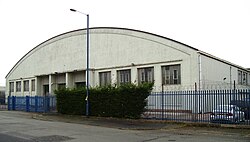
Wythenshawe Bus Garage
Wythenshawe Bus Garage is a Grade II* listed building in Wythenshawe, Greater Manchester, England.

822 m
Wythenshawe and Sale East
Wythenshawe and Sale East is a parliamentary constituency in the city of Manchester and the borough of Trafford. It returns one Member of Parliament (MP) to the House of Commons of the Parliament of the United Kingdom, elected by the first past the post system.
Wythenshawe and Sale East borders rural Cheshire to the south, and its southern tip includes Manchester Airport. The constituency has always been a safe Labour seat; the current MP is Mike Kane, who was elected at the 2014 by-election in February 2014. He succeeded Paul Goggins, who died in January 2014 having held the seat for Labour since its inception in 1997.

822 m
Northern Moor
Northern Moor is an area of Manchester, England, north of Baguley, west of Northenden and east of Sale, 5 miles south of Manchester city centre. The Tatton family lived from 1540 to 1926 at Wythenshawe Hall in Northern Moor; land around it is now Wythenshawe Park, which was a deer park from 1200 to 1540. In former centuries it was spelt "Northen Moor" and meant "the moor area belonging to Northenden". Until 1931, Northern Moor was part of Cheshire, before Manchester expanded south of the River Mersey and its borders were changed to include Northern Moor and Northenden. The area includes Lawton Moor, and the northern border is now with Sale Moor.
The area has grown since the 1930s and 1940s to cover the area of the old Tatton family estate and farms.
In 1926, Mr.Tatton (country squire at Wythenshawe Hall) sold land in Wythenshawe, and it came into the hands of Manchester Corporation, which chose four farm fields in Northern Moor to be the Manchester (Wythenshawe) Aerodrome. Its runway opened in early 1929, with the old farm house used for offices. The airfield closed a few years later, moved to Eccles and became Barton Airport. The land was redeveloped with Rackhouse School opening in 1935, St. Michael's Church in 1937, St Aidan's Catholic School in 1938, and houses built in the 1930s and 1940s on the land. Northern Moor has grown further since, expanding to the Sale border. The Kerscott estate was a fruit farm with apple and plum trees. The area is now part of the Wythenshawe and Sale East Parliament constituency.