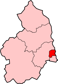
Wansbeck est un ancien district non-métropolitain du Northumberland, en Angleterre. Il doit son nom à la rivière Wansbeck. Il a été créé le 1er avril 1974 par le Local Government Act de 1972 et est issu de la fusion des districts urbains de Ashington, Bedlingtonshire et Newbiggin-by-the-Sea. Ses principales villes sont Ashington, où siégeait le conseil de district, Bedlington et Newbiggin-by-the-Sea. Il se trouve au bord de la mer du Nord, au nord de la conurbation de Tyneside. Le conseil de district a été aboli par les changements structurels de l'administration locale anglaise de 2009, entrés en vigueur le 1er avril 2009. Ses pouvoirs ont été transférés au conseil de comté du Northumberland, agissant en tant qu'autorité unitaire.

1. Source

(en) Cet article est partiellement ou en totalité issu de l’article de Wikipédia en anglais intitulé « Wansbeck » (voir la liste des auteurs).

1. Lien externe

(en) Site du conseil de district de Wansbeck Portail de l’Angleterre

Nearby Places View Menu
Location Image
0 m

Wansbeck District

Wansbeck was a local government district in south-east Northumberland, England. Its main population centres were Ashington, Bedlington and Newbiggin-by-the-Sea. The area which was bounded by the district is mostly urban, on the North Sea coast north of the Tyneside conurbation. It bordered Blyth Valley district to the south, the border being the River Blyth. It was formed on 1 April 1974, under the Local Government Act 1972, by the merger of the urban districts of Ashington, Bedlingtonshire and Newbiggin-by-the-Sea. It is named after the River Wansbeck. The district council was abolished as part of the 2009 structural changes to local government in England effective from 1 April 2009 with responsibilities being transferred to Northumberland County Council, a unitary authority.
Location Image
377 m

Cambois Rowing Club

Cambois Rowing Club is a rowing club on the River Wansbeck, based at Blackclose Bank, Riverside Park, Ashington, Northumberland, England and is affiliated to British Rowing. The blade colours are green with a white fly (also called outboard) triangle; kit: green.
542 m

North Seaton railway station

North Seaton railway station served the town of Ashington, Northumberland, England from 1859 to 1964 on the Blyth and Tyne Railway.
1.0 km

Stakeford

Stakeford is a large village in south east Northumberland, England. Its about 17 miles (27 km) north of Newcastle upon Tyne. It lies south of the River Wansbeck from Ashington, the nearest town. The village takes its name from the former river crossing to the north of the village, this was a crossing through the mudflats which was marked with stakes to give an idea of the water depth, hence the name Stakeford. The river crossing has long gone, but remains of the stakes can be seen in the river bed becoming visible whenever the dam downstream is opened. The old river crossing was replaced by a bridge in the early 20th century, which in itself was replaced by the new Stakeford Bridge in 1994. There is now no trace of the original ford due to the mudflats being used as a landfill site in the 1950s and 60s and the creation of a riverside country park in the 1970s. It is a mainly residential village. There are three pubs and a Social Club. There is also a miners' institute although it never had a mine as this was located in the adjacent village of Bomarsund. Stakeford has several shops and a primary school. Today Stakeford forms one built-up area, with neighbouring Guide Post and Sheepwash.
1.1 km

Ashington Academy

Ashington Academy is a secondary school and sixth form located in Ashington in the English county of Northumberland.