
 English
 Français

Charlesfield Halt railway station served the village of Charlesfield, Melrose, Scotland, from 1942 to 1961 on the Waverley Route.
Nearby Places View Menu

2.3 km
Newtown St Boswells
Newtown St Boswells (Scots: Newtoon; Scottish Gaelic: Baile Ùr Bhoisil [ˈpaləˈuːɾˈvɔʃɪl]) is a village in the Scottish Borders council area, in south-east Scotland. The village lies south of the Eildon Hills on the Sprouston and Newtown burns, approximately 40 miles (64 km) south-east of Edinburgh. It is the administrative centre of the Scottish Borders, and was historically in the county of Roxburghshire.
2.4 km
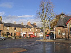
St Boswells
St Boswells (Scots: Bosels / Bosells [ˈboːzəɫz]; Scottish Gaelic: Cille Bhoisil [ˈçiʎəˈvɔʃɪl]) is a village on the south side of the River Tweed in the Scottish Borders, about 1 mile (2 kilometres) southeast of Newtown St Boswells on the A68 road. It lies within the boundaries of the historic county of Roxburghshire.
It has a hotel, post office, award-winning butcher, garage, fish and chip shop, bookshop and café and several convenience stores. There is also a golf course next to the River Tweed, a cricket club, football club, rugby club and tennis club.
The village is mostly known for being on the route of St Cuthbert's Way, a long distance footpath linking Melrose Abbey (5 miles or 8 kilometres northwest) to the Holy Island of Lindisfarne off the Northumberland coast in north east England. The name commemorates Saint Boisil, an Abbot of Melrose.
The village has an annual gypsy fair, originally a focus for the trade of horses. This fair once attracted Gypsies from most parts of Scotland, northern England and Ireland. However, today it is little more than a two-day get-together on the village green. Fair day is on 18 July each year. It remains a popular opportunity for many locals to have their fortunes predicted.

2.5 km
St. Boswells railway station
St Boswells railway station was a railway station that served the villages of Newtown St Boswells and St Boswells, Scottish Borders, Scotland from 1849 to 1969 on the Waverley Route. Although named after the larger village of St Boswells, the station was situated in Newtown St Boswells, located 1 mile (1.6 km) to the northeast.
2.5 km
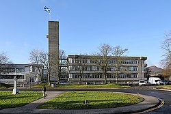
Council Headquarters, Newtown St Boswells
The Council Headquarters is a municipal building in Newtown St Boswells, in the Scottish Borders council area in Scotland. It serves as the headquarters of Scottish Borders Council.
Roxburghshire County Council built the first office on the site in 1896. The site later became that council's headquarters and meeting place in 1930, known as the "County Offices". A substantial new building was added in 1968, which forms the main part of the current building. Following local government reform in 1975 the building became the headquarters of the Borders Regional Council and was renamed "Regional Headquarters". When local government was reorganised again in 1996 the building became the headquarters of Scottish Borders Council and was renamed "Council Headquarters".