Newtown St Boswells (Scots: Newtoon; Scottish Gaelic: Baile Ùr Bhoisil [ˈpaləˈuːɾˈvɔʃɪl]) is a village in the Scottish Borders council area, in south-east Scotland. The village lies south of the Eildon Hills on the Sprouston and Newtown burns, approximately 40 miles (64 km) south-east of Edinburgh. It is the administrative centre of the Scottish Borders, and was historically in the county of Roxburghshire.

1. History

Newtown St Boswells is an old settlement, well-established by the 16th century. The town has been known at various times as Newtoune, Newtown of Eildon, Neuton and Newtown of Dryburgh. It lies split between the civil parishes of Melrose and St Boswells. Historically, Newtown St Boswells was a centre for milling grain, with watermills on its burns. It became a regional centre of communication and an exporter of livestock after the opening of its railway station. This importance has declined since the closure of the station in 1969.

Roxburghshire County Council established offices at Newtown St Boswells in 1896, and subsequently moved its meeting place there from Jedburgh in 1930. A large new building was added to the site in 1968. From 1975 to 1996, the offices served as the administrative centre for Borders Regional Council. Since the 1996 the offices have been the headquarters of Scottish Borders Council and known as the Council Headquarters.

1. Education

The village is served by Newtown Primary School, which is a feeder school to Earlston High School, about 5 miles (8.0 km) away in Earlston. The primary school also has nursery provision for preschool-aged children. A Borders College campus at the southeastern tip of the village specialises in agricultural education.

1. References


1. External links

RCAHMS/Canmore: Newtown St Boswells, St Boswells Station and Granary Archived 18 October 2012 at the Wayback Machine Gazetteer for Scotland: Newtown St Boswells Scottish Borders Council, regeneration of Newtown St Boswells

Nearby Places View Menu
Location Image
167 m

St. Boswells railway station

St Boswells railway station was a railway station that served the villages of Newtown St Boswells and St Boswells, Scottish Borders, Scotland from 1849 to 1969 on the Waverley Route. Although named after the larger village of St Boswells, the station was situated in Newtown St Boswells, located 1 mile (1.6 km) to the northeast.
Location Image
172 m

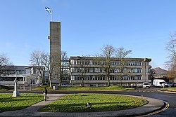
Council Headquarters, Newtown St Boswells

The Council Headquarters is a municipal building in Newtown St Boswells, in the Scottish Borders council area in Scotland. It serves as the headquarters of Scottish Borders Council. Roxburghshire County Council built the first office on the site in 1896. The site later became that council's headquarters and meeting place in 1930, known as the "County Offices". A substantial new building was added in 1968, which forms the main part of the current building. Following local government reform in 1975 the building became the headquarters of the Borders Regional Council and was renamed "Regional Headquarters". When local government was reorganised again in 1996 the building became the headquarters of Scottish Borders Council and was renamed "Council Headquarters".
1.2 km

Eildon

Eildon is the largest committee area of the Scottish Borders Council, with a population of 34,892 at the census in 2001. It contains the three Eildon Hills, the tallest in the Scottish Borders. Eildon is the name of a hamlet within the area, just north-west of Newtown St Boswells.
Location Image
1.4 km

Dryburgh Abbey Bridge

Dryburgh Abbey Bridge was a cable-stayed footbridge of significant historical interest near Dryburgh Abbey, in the Borders of Scotland. It connected the villages of Dryburgh and St. Boswells (part of a ribbon of settlements, including Newtown St. Boswells) across the River Tweed. A crossing had existed here for centuries, originally with a ferry service. The bridge had been commissioned by David Stewart Erskine, 11th Earl of Buchan, an eccentric Scottish aristocrat who died in Dryburgh. It was 79 metres (259 ft) long. At the time, the cable-stayed type of bridge was rapidly becoming more popular. The Earl opened the completed bridge on 1 August 1817, but in January 1818 it collapsed. One of the designers, Thomas Smith, said of the collapse that due to "high wind increasing to [a] perfect hurricane, it carried off [the] chain bridge, leaving only the fastenings and supports, the work of half a year, demolished in an hour...." After a redesign, a replacement was built, but this too collapsed in 1838, by which time the Earl had been dead for several years. The 1818 collapse, together with that of a slightly shorter bridge across the Saale River in Germany in 1824, caused the reputation of cable-stayed bridges to decline rapidly, and despite a history dating back to the 17th century, the design fell from favour for several decades, with combination cable-stayed and suspended-deck suspension bridges (such as the 1883 Brooklyn Bridge) gaining favour. Later research in the 1930s, and experience with reconstruction after the Second World War, demonstrated that with sound design, pure cable-stayed bridges are viable, and the first modern design, the Strömsund Bridge in Sweden, was completed in 1955. Very shortly after the 1818 collapse (between 1819 and 1820) another bridge, the Union Bridge, was built some 40 kilometres (25 mi) downstream. It was an iron suspended-deck suspension bridge, the longest in the world upon its completion. A third Dryburgh Suspension Bridge was built in 1872 to replace the 1838 loss.