
 English
 Français

The Leaderfoot Viaduct, also known as the Drygrange Viaduct, is a railway viaduct over the River Tweed near Melrose in the Scottish Borders.
Nearby Places View Menu
158 m
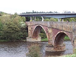
Drygrange Old Bridge
The Drygrange Old Bridge is a disused road bridge over the River Tweed near Melrose in the Scottish Borders.

421 m
Leader Water
Leader Water is a small tributary of the River Tweed in Lauderdale in the Scottish Borders. It flows southwards from the Lammermuir Hills through the towns of Lauder and Earlston, joining the River Tweed at Leaderfoot.

519 m
Newstead Helmet
The Newstead Helmet is an iron Roman cavalry helmet dating to 80–100 AD that was discovered at the site of a Roman fort in Newstead, near Melrose in Roxburghshire, Scotland in 1905. It is now part of the Newstead Collection at the National Museum in Edinburgh. The helmet would have been worn by auxiliary cavalrymen in cavalry displays known as hippika gymnasia. Its discoverer, Sir James Curle (1862–1944), described the helmet as "one of the most beautiful things that the receding tide of Roman conquest has left behind".
685 m
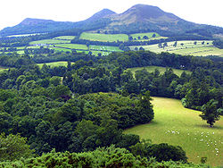
Trimontium (Newstead)
Trimontium was a Roman fort complex located at Newstead, near Melrose, in the Scottish Borders, beneath the three Eildon Hills which almost certainly gave it its name (Latin: trium montium, three hills).
It was occupied intermittently from about 79 to 184 AD and was the largest of the "outpost" forts after the construction of Hadrian's Wall in the 120s AD. It was located 60 mi (100 km) north of the wall on the extension of Dere Street the main Roman route to the north, initially in seemingly "hostile" territory. Trimontium was about three times larger than any fort on Hadrian's Wall and by 180 became the most northerly settlement of the whole Roman Empire.
Trimontium is also considered of international importance as the site of one of the largest caches of Roman military objects in Britain, found in 117 pits.
It was identified by Roman geographer Ptolemy in his Geography.
The fort sits on the banks of the River Tweed, with the Eildon Hills and the Iron Age hillfort atop Eildon North, a visible reminder of both the local population and imposing landscape of the Scottish Borders. The location benefitted from the rivers Tweed and Leader providing routes for the movement of goods and people and from the Roman road that became Dere Street passing alongside the fort.