
 English
 Français

Keld, Cumbria
Keld (or Keilde) is a hamlet in the English county of Cumbria. It lies within the civil parish of Shap. On the banks of the River Lowther it is a mile southwest of Shap and falls within that village's civil parish, Shap Abbey is nearby. Keld's medieval chapel (right) is noted for its unusual simplicity.
1. See also
Listed buildings in Shap
1. External links
Video footage and history of Keld Chapel
Map sources for Keld, Cumbria
Nearby Places View Menu
1.0 km
Shap Abbey
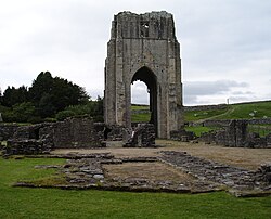
Shap Abbey was a religious house of the Premonstratensian order of Canons regular situated on the western bank of the River Lowther in the civil parish of Shap Rural, around 1.5 miles (2.4 km) from the village of Shap, in Westmorland and Furness, Cumbria, England. The site is in the care of English Heritage and managed on its behalf by the Lake District National Park.

1.2 km
Shap
Shap is a village and civil parish located among fells and isolated dales in Westmorland and Furness, Cumbria, England. The village is in the historic county of Westmorland. The parish had a population of 1,221 in 2001, increasing slightly to 1,264 at the 2011 Census.
1.3 km
Shap railway station
Shap railway station served the village of Shap, Westmorland (now in Cumbria), England for over 120 years.

1.8 km
Shap Stone Avenue
Shap Avenue is the name given to a, now mostly destroyed, megalithic complex near the village of Shap in Cumbria, England, comprising at least two stone circles, a two-mile avenue of megalithic standing stones, and several adjacent burial mounds. Before its destruction, it was one of the largest megalithic monuments in Europe. As it survives today, the site comprises a rough and highly damaged avenue of stones arranged over a mile, aligned northwest. At its southern end is the avenue's terminal, a stone circle named 'Kemp Howe', which has been mostly buried by a rail embankment.
The place name ‘Shap’ alludes to the Avenue, as it derives from the word ‘Hep’, meaning a pile of stones; this would later be written as ‘Hyep’, and bastardised to ‘Shap’. Up until the 18th century, Shap Avenue was comparable to Avebury in Wiltshire, making it a popular tourist destination for antiquarians. William Stukeley, famous for his work at Avebury, visited the site before its destruction, sometime before 1725. He said of Shap Avenue:
“Though it's ourney be northward ... it makes a very large curve, or an arc of a circle, as those at Avebury, and passes over a brook too. A spring likewise arises in it, near the Greyhound inn.”
Stukeley had earlier received a plan of the monument from a local antiquarian (now missing). Of this, he notes:
"I have gott a vast drawing and measurement from Mr. Routh, of Carlisle, of the stones at Shap, in Westmoreland, which I desired from him. They give me so much satisfaction that verily I shall call on you next year to take another religions pilgrimage' with me thither. I find it to be, what I always supposed, another huge serpentine temple, like that of ABVRY. The measure of what are left extends a mile and a half, but without doubt a great deal of it has been demolished by the town, and by everything else thereabouts..."