
 English
 Français

Shap is a village and civil parish located among fells and isolated dales in Westmorland and Furness, Cumbria, England. The village is in the historic county of Westmorland. The parish had a population of 1,221 in 2001, increasing slightly to 1,264 at the 2011 Census.
1. Location
The village lies along the A6 road and the West Coast Main Line, and is near to the M6 motorway. It is situated 10 miles (16 km) from Penrith and about 15 miles (24 km) from Kendal. Shap is on the route of the Coast to Coast Walk.
1. Toponymy
Early (12th and 13th century) forms such as Hep and Yheppe point to an Old Norse rendering Hjáp of an Old English original Hēap = "heap" (of stones), probably referring to an ancient stone circle, cairn or to the Shap Stone Avenue just to the west of the village.
1. History
Although Shap is a small village in terms of population, it is legally a market town with a charter dating from the 17th century. The parish was administered between 1905 and 1935 by an urban district council. At one time, the granite works situated a mile outside the village was a separate community, with its own Co-op store. Shap polished pink granite can be found in many buildings in the UK, including outside St Paul's Cathedral in London.
1. Climate
Shap has a oceanic climate (Köppen: Cfb), like the vast majority of the British Isles.
At an elevation of 255m (837 ft), Shap is notably cooler as well as wetter than surrounding lowland areas, and considerably wetter than lowland Southern England, as it is exposed to the prevailing west-southwesterlies enhanced by orographic lift.
1. Today
The village has three pubs, a small supermarket, a fish and chip shop, a primary school, a newsagent's, a coffee shop, a charity shop named "Second Chance", a fire station, an Anglican church and 3 B&B/ Hostels. There is also a small library which, in 2014, was in the process of being relinquished from local council control and being adopted by the community as part of a budget cutting measure. As of 2025, it is operated as "Shap Library Link" by the local council. Major employers in the area are Hanson, Tebay Services and Tata Steel. Some of the scenes in the feature film Withnail and I were filmed around Shap. Sleddale Hall, the filming location for Uncle Monty's cottage Crow Crag, is located near Wet Sleddale Reservoir. On 22 October 1999, a Hawk jet from RAF Leeming crashed into an empty barn in the village before disintegrating across the A6 and West Coast railway line, killing its two-man crew. On 3 November 2025, a Glasgow to London Avanti West Coast train with 86 passengers and five crew derailed near the village due to a landslide. There were four minor injuries.
1. Attractions
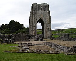
Shap Summit is located on the motorway at NY583120 and the railway at NY570110. Before the M6 opened, Shap Fell used to be notorious for the difficult and dangerous stretch of A6 for drivers, and it includes a well-known section of the West Coast Main Line. It has a 1:75 gradient for trains heading north, and in the days of steam locomotives banking engines from Tebay were often used to assist trains. It has been popular with railway photographers and there have been many pictures published taken in the area, most notably at Scout Green which lies on the southern approach to the hill. Shap Fell NY530088 is known for Shap granite, a pink rock rich in orthoclase, quartz and biotite; Shap Pink Quarry NY557083 takes its name from this. Shap Abbey NY547151 is nearby in the secluded valley of the river Lowther. Now impressive ruins dating from 1199, the Abbey was one of the last abbeys to be dissolved by Henry VIII in 1540. Shap Wells has a mineral spa located in the grounds of the Shap Wells hotel which was used in World War II as a prisoner of war camp.
1. In literature
A scene in Robert Neill's historical novel Crown and Mitre is laid in Shap. In 1659 the book's protagonist Hal Burnaby, a young Royalist, rides through the village on a clandestine mission connected with the restoration of King Charles II. Shap also appears in Anthony Trollope's novel Can You Forgive Her? as the nearest village to Vavasor Hall, the ancestral home of the heroine Alice Vavasor. In M. W. Craven's novels, Shap Wells hotel is often used as a hub for the stories since one of the main characters, Washington Poe, lives nearby.
1. Governance
The civil parish of Shap (formerly Shap Urban Parish) includes the hamlet of Keld and parts of the granite works and limestone works. In 2001 it had a population of 1,221, increasing to 1,264 at the 2011 Census. The parish shares a joint parish council with Shap Rural. The total population of the since abolished Shap electoral ward taken at the 2011 census was 1,394.
Shap is in the parliamentary constituency of Westmorland and Lonsdale. For local government purposes the village is in Westmorland and Furness. Until 2023 it was in the Shap Ward of Eden District Council and the Eden Lakes Division of Cumbria County Council.
1. Transport
The Lancaster and Carlisle Railway (now part of the West Coast Main Line), opened on 17 December 1846, and runs along the eastern edge of the village. Shap station was closed in 1968, though there have been calls for its re-opening. Penrith is now the closest station and is situated on the West Coast Main Line.
1. Dialect
Though the majority of the village's inhabitants speak standard English, some locals speak a variant of the Penrithian dialect, which is itself a variant of the Cumbrian dialect spoken around the Penrith and Eden district area. These dialectal varieties stem from Northern Middle English and in turn Northumbrian Old English.
1. Notable people
Sir Charles Richardson (1769-1850), Royal Navy officer was born in the village
1. See also
Listed buildings in Shap
1. References


1. External links
Cumbria County History Trust: Shap (nb: provisional research only – see Talk page) Shap Community Website – Maintained by the Parish Council Shap Air Crash Anniversary Rail Worker's Monument, Shap Video footage and history of Keld Chapel Video footage of the Shap Wells Spa and Hotel
Nearby Places View Menu
Shap railway station

Keld, Cumbria
Shap Abbey
