
 English
 Français

Oxton (Yorkshire du Nord)
Oxton est un village et une paroisse civile du Yorkshire du Nord, en Angleterre.
Nearby Places View Menu

10 m
Oxton, North Yorkshire
Oxton is a village and civil parish in North Yorkshire, England, and about 8 miles (13 km) south-west from the county town and city of York. The parish touches Bolton Percy, Grimston, Kirkby Wharfe with North Milford, Steeton and Tadcaster. In 2001 the parish had a population of 20.
The name "Oxton" means 'Ox farm/settlement', and was recorded in the Domesday Book as "Ositone". The lord of the manor in 1086 was Osbern D'Arques, who had received the manor of a 2 ploughlands area from the 1066 lord Alwin, and who was also tenant-in-chief to king William I. Also listed within Oxton is Ouston Farm, of 2 ploughlands and a meadow of 4 acres (1.6 hectares), which was under the lordship of Toki, son of Auti in 1066, and which passed to Fulco, son of Rainfrid in 1086 under William de Percy, the tenant-in-chief to William. Within the parish is the deserted medieval village of Oulston.
Oxton was formerly a township in the parish of Tadcaster, and in 1866 became a civil parish in its own right. From 1974 to 2023 it was part of the district of Selby, it is now administered by the unitary North Yorkshire Council.
There are two Grade II listed buildings in Oxton, the mid-18th-century Oxton Grange, and the early 18th-century Oxton Hall.
785 m
Oxton Hall
Oxton Hall is a grade II listed country house in the town of Oxton, North Yorkshire.
The hall was built in the early 18th century. It is home to Humphrey Smith, the owner and chairman of Samuel Smith Old Brewery, based in nearby Tadcaster. The hall was acquired by Humphrey’s grandfather, Samuel Smith, in 1919.
The hall is built of reddish-brown brick with the front in Tadcaster limestone, on a plinth, with a moulded cornice, a low parapet, and a hipped Welsh slate roof. There are two storeys and seven bays, the middle three bays projecting under a pediment. In the centre is a single-storey, tetrastyle Greek Doric portico, a frieze with triglyphs, a modillion cornice and a low parapet. The windows are sashes, those on the ground floor with aprons, and between the upper floor windows are round-headed niches. At the rear is a verandah. It has been grade II listed since 1967.

1.4 km
Cock Beck
Cock Beck is a stream in the outlying areas of eastern Leeds, West Yorkshire, England, which runs from its source due to a runoff north-west of Whinmoor, skirting east of Swarcliffe and Manston (where a public house has been named 'The Cock Beck'), past Pendas Fields, Scholes, Barwick-in-Elmet, Aberford, Towton, Stutton, and Tadcaster, where it flows into the River Wharfe.
It is a tributary of the River Wharfe, formerly known as the River Cock or Cock River, having a much larger flow in the past than it does today. The name 'cock' may refer to a mature salmon, as it was a spawning ground for salmon and trout. Industrial pollution reduced the fish stock, but it has been recovering in the 21st century, aided by work from the Environment Agency. In places the beck was relatively narrow, but too deep to cross unaided; a feature which can still be seen today at many points.

1.5 km
Tadcaster Albion A.F.C.
Tadcaster Albion Association Football Club is an association football club in Tadcaster, North Yorkshire, England. Formed in 1892, their ground is situated behind the John Smith's Brewery in Tadcaster, thus the reason for their nickname "The Brewers". They compete in the Northern Counties East League Premier Division.
1.7 km
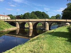
Tadcaster Bridge
Tadcaster Bridge or Wharfe Bridge spans the River Wharfe in Tadcaster, North Yorkshire, England. The road bridge is believed to date from around 1700. It is the main route connecting the two sides of the town and one of two road crossings in the town, the other being the bridge for the A64 bypass. Tadcaster Bridge partially collapsed on 29 December 2015 after flooding that followed Storm Eva, and reopened on 3 February 2017.