
 English
 Français

Sabden Brook
Sabden Brook is a small river running through Lancashire in England. It is 7.59 miles (12.21 km) long and has a catchment area of 6.84 square miles (17.723 km2). Rising just to the west of Newchurch-in-Pendle, Sabden Brook moves westward through its well-defined valley past Sabden Hall to the village of Sabden east of the town of Whalley. From there the brook turns southwesterly, widening out overlooked by Wiswell Moor and the ancient hillfort at Portfield, before conjoining with the waters of the River Calder at Cock Bridge near Read. Sabden is believed to have been derived from Old English words sæppe denu, meaning valley of the spruce trees. Brook (OE broc) is a common name for a stream most often found in southern and central England.
Lieux à Proximité Voir Menu
538 m
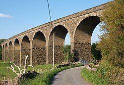
Martholme Viaduct
Martholme Viaduct is a railway bridge near Great Harwood in Lancashire, north-western England. It was built from 1870 and opened in 1877 after construction was beset by landslips. It closed in 1954 and is now a cycle way. It is a Grade II listed building.

676 m
Martholme
Martholme is a Grade I listed medieval manor house standing on the banks of the River Calder 1+1⁄4 miles (2 km) from Great Harwood, Lancashire, England and 5 miles (8 km) north-east of Blackburn.
1.3 km
Read Hall and Park
Read Hall and Park is a manor house with ornamental grounds of about 450 acres (180 ha) in Whalley Road, Read, a few miles west of Padiham, Lancashire, England.
The current hall dates from the early 19th century and is a Grade II* listed building. The landscaped grounds date from around the same time and feature a waterfall, two lakes and woodland. There is also a rockery, rose garden and terrace, plus a fountain and gardens near the house of about 25 acres (10 ha). The hall and park are not open to the public.

1.4 km
Portfield Hillfort
Portfield also known as Planes Wood Camp is a late Bronze Age or Iron Age hillfort situated close to the town of Whalley in Lancashire, Northern England. It is thought to have originally been constructed as a univallate structure and then modified into a small multivallate one sometime after.
It is located on a slight promontory overlooking the valley of the River Calder, with the ground falling particularly rapidly to the west. A flat, possibly artificially levelled area measuring approximately 165 by 110 metres (541 by 361 ft), appears to have originally enclosed by a single rampart, with a least one entrance on the northern side. The irregularly-shaped site, with an area a little over 1.4 hectares (3.5 acres), is 120 metres (400 ft) above sea level. The surrounding land slopes fairly steeply on the southeast, and little less so on the northwest sides, while to the northeast the drop is only slight. No evidence remains of a bank on the western side and it could be that the slope here, which is most extreme on the upper 15 metres (50 ft), may have been considered defence enough.
Generally the defences have not survived well, but at the northwest corner where they are best preserved, there is a section of triple bank and ditch up to 1.5 metres (4 ft 11 in) high, thought to represent later modifications.
Today the site is protected as a scheduled monument, but it was not until 1981. Starting in the 1950s, the Haweswater Aqueduct was constructed through the site. As part of the work, limited archaeological excavation undertaken in 1957, discovered a section of cobbled pavement at the entrance and pottery dated to the second century AD. In 1966, workmen laying an additional pipeline across the hillfort, discovered a hoard of nine Bronze Age artefacts including a gold bracelet and lock ring. Additional small digs in the 1960s and 70s recovered finds dating from the Neolithic period through to Middle Ages.
Planes Wood is an area of woodland on the steep slope to the west. Since at least the 16th century, the name Portfield has been attached to a farm at the northeast edge of the site.
The English word 'port' may have been borrowed from the Latin portus, a possible meaning of which is haven or refuge.
Historic England consider Portfield to be a rare example in north west England of a univallate hillfort subsequently modified to become multivallate.