
 English
 Français

Arnfield
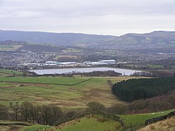
Arnfield is an area of Derbyshire, England. It is located on the north side of Tintwistle (where the population is included), adjacent to the Arnfield Reservoir.
Nearby Places View Menu

425 m
Tintwistle
Tintwistle ( TIN-səl) is a village and civil parish in the High Peak district of Derbyshire, England, which had a population of 1,400 at the 2011 census. The village is just north of Glossop at the lower end of Longdendale Valley. Tintwistle, like nearby Crowden and Woodhead, lies within the historic county boundaries of Cheshire.

500 m
Tintwistle Rural District
Tintwistle Rural District was a local government district in north east Cheshire, England from 1894 to 1974.
It was created a rural district by the Local Government Act 1894 from the part of the Ashton-under-Lyne rural sanitary district which was in Cheshire. It consisted of the civil parishes of:
Tintwistle
Hattersley (until 1936)
Matley (until 1936)
Hattersley and Matley formed an exclave of the district. They were abolished in 1936 and their area transferred to the Municipal Borough of Hyde, the Municipal Borough of Dukinfield, Longdendale Urban District and the Municipal Borough of Stalybridge.
In 1974 the district was abolished. At that time, much of north east Cheshire became part of Greater Manchester. Instead of becoming part of that county, or forming an exclave of Cheshire, Tintwistle became part of the High Peak district of Derbyshire.
571 m
Arnfield Reservoir
Arnfield Reservoir is a man-made lake in Longdendale in north Derbyshire, England. It was constructed in 1854 as part of the Longdendale chain to supply water from the River Etherow to the urban areas of Greater Manchester. Unlike the other reservoirs in the chain, Arnfield and Hollingworth Reservoir are not in the Etherow valley but lie in the valley of tributary brooks to the north and above (Arnfield lies around 1 mile from Bottoms Reservoir in the Longdendale Chain). From Arnfield the water is extracted to pass through the Mottram Tunnel to Godley.
The Manchester Corporation Waterworks Act 1847 (10 & 11 Vict. c. cciii) gave permission for the construction of the Woodhead, Arnfield and Hollingworth Reservoirs and an aqueduct to convey waters to a service reservoir at Godley. The Manchester Corporation Waterworks Act 1848 allowed the construction of Torside and Rhodeswood Reservoirs, and an aqueduct to convey the water to the Arnfield reservoir.
The earthen embankment is 17 metres (56 ft) high and the five sections total 953 m (3,127 ft) in length. It was constructed of local clay; a masonry overflow weir protects the reservoir from overtopping. Beneath it lay the trapezoidal Longdendale aqueduct that followed the contour to take water from the reservoirs to the Godley reservoir. Until the 1960s, water was treated by passing it through straining frames at Godley.
In the 1960s, a more sophisticated system of treatment was employed. Treatment plants were built at Arnfield and Godley. At Arnfield, lime, ferric sulphate and polyelectrolyte are added to the water in mixing chambers. This flocculating agent binds together the impurities, which sink and are removed in sedimentation tanks. At Godley, lime is added to remove manganese, and the water is filtered and chlorinated and fed into the distribution network.
Also in the 1960s, part of the Longdendale aqueduct was replaced with 1,200 mm (47 in) diameter pipes. In 1990, the Hollingworth Reservoir (now part of Swallows Wood nature reserve) was decommissioned and levelled and waters from the Ogden Brook fed into Arnfield. In 2004, two sections of the embankment were strengthened.

975 m
Swallows Wood
Swallows Wood is a nature reserve near Hollingworth, Tameside, straddling the border between Greater Manchester and north Derbyshire. The 60-acre (0.24 km2) reserve, which contains semi-natural woodlands, meadows, ponds and marsh areas, is owned by United Utilities who are responsible for its management. The site was formerly occupied by the Hollingworth and Waste Lodge reservoirs; these were demolished in 1987, and the nature reserve was installed in their place. Arnfield Reservoir, the lowest of the Longdendale Chain reservoirs, is nearby.
The route of the proposed Longdendale Bypass would pass through the nature reserve and there is an ongoing campaign to save the wood. Although the bypass has been threatening the wood for nearly 30 years Tameside Council have recently committed to planting 10,000 managed trees, in an attempt to move the woodland gradually away from the bypass route.
The wood is on the fringes of the Peak District National Park; many walkers enjoy the area as the views over the woods and moorland are particularly impressive.