
 English
 Français

Grike (Lake District)
Grike is a hill in the west of the English Lake District, near Ennerdale Water. It is part of the Lank Rigg group, the most westerly Wainwright as the fells diminish toward the coastal plain. It can be climbed from Kinniside or Ennerdale Bridge.

St Mary's Church, Barnetby
St Mary's Church is a redundant Anglican church in the village of Barnetby, Lincolnshire, England. It is recorded in the National Heritage List for England as a designated Grade I listed building, and is under the care of the Churches Conservation Trust.

Central Embarcadero Piers Historic District
The Central Embarcadero Piers Historic District is a Registered Historic District in the city of San Francisco, California, United States. It consists of Piers 1, 1½, 3 and 5, which form one of the largest surviving pier complexes along San Francisco's Embarcadero waterfront road. It was added to the National Register of Historic Places in 2002.

Castle Knowe, Northumberland
Castle Knowe, also known as Clinch Castle, is the site of an Iron Age hillfort in Northumberland, England, about 1 mile south-east of the village of Ingram. It is a scheduled monument.

Golden Ball, York
The Golden Ball is a pub in the Bishophill area of central York, in England.
The first record of the pub was in 1773. The core part of the building was constructed in the early 19th century. In 1883, a house for the publican was constructed by Benson & Minks, adjoining the pub. The pub was sold to Braime's Brewery in 1884, and this in 1902 was taken over by John Smith's Brewery. In 1929, the pub was constructed by their architect Bertram Wilson. He combined the two buildings, raised the ceiling height in the older part of the building, and decorated the front of the pub.
In the 1990s, an additional room was added to the pub, from what was formerly a private area. The pub has otherwise been little altered since the 1920s, and is described by the Campaign for Real Ale (CAMRA) as "the most complete surviving inter-war scheme by John Smith's". In 2010, the pub was grade II listed on the initiative of CAMRA, and it appears on that organisation's National Inventory of Historic Pub Interiors.
In 2012, the pub was taken over by a co-operative of local residents. Since then, it has held beer festivals, an annual summer fete, and sells works by local artists. It also hosts local music nights.
The pub has two storeys and a cellar. The whole building is constructed of brick, but the older part, on the corner of Victor Street, has tiling at the ground floor level, and is rendered at the first floor. Its entrance is on Cromwell Road, opening onto a corridor, with the former smoke bar on the left, and the public bar on the right. Historic England notes that it has the only known surviving example of a "bar-side seating alcove", known as a "hall". There is a now-disused doorway for take-away sales, signed "Jug & Bottle Dept". The ground floor windows on Victor Street incorporate etched glass, advertising John Smiths and Magnet Ales. Many internal fittings survive from the 1929 redesign, including doors, tiling, flooring, and the bar.

All Saints' Church, Moor Monkton
All Saints' Church is the parish church of Moor Monkton, a village north-west of York in England.
The church dates from the 12th century, when the nave and chancel were constructed. From this period survives some of the stonework, the two south doorways, two windows in the north wall, and the lower part of the chancel arch. The church was largely rebuilt in 1638 by Sir Henry Slingsby, who added a brick tower. In 1879, the church was heavily restored by James Fowler, who replaced the tower, and removed most of the furnishings and stained glass.
The church was Grade II* listed in 1966. Lying a mile south of the village of Moor Monkton, it was lit only by candles, oil and gas lamps until 2009, when it was finally connected to the electric grid.
The church is built of sandstone and gritstone, with a tile roof. The nave is of four bays, and the chancel of three. The tower has three stages and full-height buttresses. There is a parapet, with gargoyles in the form of animal heads. Built into the porch is a slab which depicts the head and feet of a priest. Inside, there is a small figure with a missing head, and an 18th century memorial showing a figure on a bier.

Kirn, Dunoon
Kirn is a village on the Cowal Peninsula, in Argyll and Bute in the Scottish Highlands on the west shore of the Firth of Clyde on the Cowal peninsula. It now forms part of the continuous habitation between Dunoon and Hunters Quay, where the Holy Loch joins the Firth of Clyde. It originally had its own pier, with buildings designed by Harry Edward Clifford in 1895, and was a regular stop for the Clyde steamer services, bringing holidaymakers to the town, mostly from the Glasgow area.


Ochiltree Castle, West Lothian
Ochiltree Castle (previously: Uchiltre; meaning: the high town or high dwelling place) is a 16th-century tower house a few miles south east of Linlithgow in West Lothian, Scotland. It is also described as a farmhouse and lairds house. Along with its boundary wall, the castle was designated as a Category A listed building in 1971.

St Mary's Church, Nantwich
St Mary's Church is an Anglican parish church in Nantwich, Cheshire, England. The church is recorded in the National Heritage List for England as a designated Grade I listed building. It has been called the "Cathedral of South Cheshire" and it is considered by some to be one of the finest medieval churches, not only in Cheshire, but in the whole of England. The architectural writer Raymond Richards described it as "one of the great architectural treasures of Cheshire", and Alec Clifton-Taylor included it in his list of "outstanding" English parish churches.
The building dates from the 14th century, although a number of changes have since been made, particularly a substantial 19th-century restoration by Sir George Gilbert Scott. The church and its octagonal tower are built in red sandstone. Features of the church's interior include the lierne-vaulted ceiling of the choir, the carved stone canopies of the sedilia in the chancel, and the intricately carved wooden canopies over the choirstalls together with the 20 misericords at the back of the stalls. The church is an active Anglican parish church in the diocese of Chester, the archdeaconry of Macclesfield and the deanery of Nantwich.

Chester-le-Street Amateur Rowing Club
Chester-le-Street Amateur Rowing Club is a rowing club on the River Wear, based at the Riverside Sports Complex, Chester-le-Street, County Durham. The blade colours are red, royal blue and a white diagonal stripe; kit: red & royal blue.

New Street (York)
New Street is a road in the city centre of York, in England.

Hospital Garrahan
Hospital de Pediatría S.A.M.I.C. "Prof. Dr. Juan P. Garrahan", commonly known as Hospital Garrahan, is a public hospital in Buenos Aires, Argentina, located in the neighborhood of Parque Patricios. Since it opened on 25 August 1987, it has become the leading public, free and high-complexity pediatric hospital in the country.
It is a highly specialized medical center, with over 3000 employees, state-of-the-art technology and progressive cares. It is jointly funded by the federal government of Argentina (80%) and by the Buenos Aires City Government (20%).
Federal funding, however, has been frozen since 2024, which has ignited a conflict between the government and the hospital staff.
Bedlington Academy
Bedlington Academy (formerly Bedlingtonshire Community High School) is a coeducational secondary school and sixth form in Bedlington in the English county of Northumberland.

Ochil Fault
The Ochil Fault is the geological feature which defines the southern edge of the Ochil Hills escarpment in Scotland.
North of the fault, Devonian lava flows and pyroclastic deposits slope gently down, thinning towards the north. These are in part overlain by Old Red Sandstone rocks formed later in the Devonian period. Because the deposits thin towards the north, and there are few signs of volcanic necks within the Ochil Hills themselves, it is thought that the eruptive centres were south of the fault, however these are buried deep beneath the Carboniferous rocks including coal measures which are found beneath the low-lying carse lands to the south.
To put this in perspective, the prominent hill Dumyat which defines the western extremity of the Ochil Hills has a height of 418 metres (1,371 ft). The nearest colliery, Manor Powis, approximately 2 kilometres (1.2 mi) south of the fault, was approximately the same depth, in carse land that is scarcely above sea level, and was mining coal from Carboniferous strata at least many hundreds of metres above the top of the Devonian deposits. The Ochil Fault was active from the earliest part of the Carboniferous period, allowing the marine swamps in which the coal-producing vegetation flourished to be periodically overlain by layers of sand, forming sandstone, or silt, forming shale, in a number of cyclic subsidences. These occurred in the form of basins, and the pattern of movements was complex, however it is known that the greatest vertical movement was centred about 1 kilometre (0.62 mi) east of the town of Alva, and almost certainly exceeded 5 kilometres (3.1 mi) vertically. The deepest deposits of coal measures are obviously found in this region, but this has not been mined to its full extent, probably due to the great depth involved.
The point of maximum downwards movement south of the fault lies just south of the Silver Glen, which happens to be the part of the Ochil Hills where the greatest extent of mineralisation has been discovered. The minerals, including ores of silver and cobalt, were probably emplaced by hydrothermal solutions percolating upwards through various minor faults and fractures, in the Tertiary period.
The Ochil Fault remained active throughout geological time, and some later movements allowed intrusive eruptions of diorite or quartz-dolerite to rise at various places along its length.
Modern movements of the fault are very minor but occasionally give rise to discernible earthquakes, particularly in the village of Menstrie, and the town of Tillicoultry. However the latter may be easily confused with the collapse of old room and pillar coal mine workings which undoubtedly underlie the southern part of the town.
The Ochil Fault is one of Britain's finest examples of a fault line scarp, and can be best appreciated from vantage points such as the Wallace Monument near Stirling.
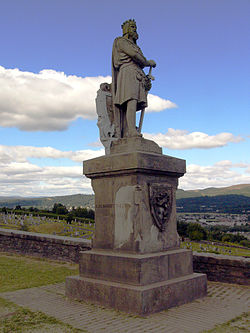
Statue of Robert the Bruce, Stirling Castle
The statue of Robert the Bruce on the esplanade at Stirling Castle, Stirling, is a 1876 work sculpted by Andrew Currie and designed by illustrator George Cruikshank. As of 2020, the statue is featured on the Clydesdale Bank £20 note.

Saxton with Scarthingwell
Saxton with Scarthingwell is a civil parish just south of Tadcaster in North Yorkshire, England. The parish contains the villages of Saxton and Scarthingwell, with two churches and the remains of a castle. Historically the area was a township, however it has been its own civil parish since 1866. Although the main part of the Battle of Towton was fought to the north out of the parish, some of the dead were interred in the parish, and at least one minor skirmish was fought within the parish boundaries.
The parish shares a grouped parish council with Lead.
Gartcairn F. A. Juniors
Gartcairn Football Academy Juniors, commonly referred to as Gartcairn Juniors, are a Scottish semi-professional football club from the town of Airdrie, North Lanarkshire who play in the West of Scotland League First Division.

Preston-le-Skerne
Preston-le-Skerne is a hamlet in the civil parish of Mordon, County Durham, England. It is situated a short distance to the east of Newton Aycliffe.

Jordanhill
Jordanhill (Scots: Jordanhull, Scottish Gaelic: Cnoc Iòrdain) is an affluent area of the West End of the city of Glasgow, Scotland. The area consists largely of terraced housing dating from the early to mid 20th century, with some detached and semi-detached homes and some modern apartments.
Jordanhill College of Education and then the University of Strathclyde faculty of education were formerly in the area and the associated school has a high reputation.