
 English
 Français

Woolley Bridge
Woolley Bridge is an area in Glossopdale, on the border of Greater Manchester and Derbyshire in England. It lies 10 miles from Manchester city centre. It is in the ward of Hadfield South.
Nearby places include Hollingworth, Dinting Vale, Gamesley, Glossop and Mottram.

Mab's Cross
Mab's Cross, in Wigan, Greater Manchester, England, is a stone cross probably dating from the 13th century with its first recorded mention taking place in 1277. It is one of four stone crosses originally used as waymarkers along the medieval route from Wigan to Chorley. The cross no longer stands in its original position, having been moved across the road in 1922 as part of a road widening scheme.

Our Lady's High School, Motherwell
Our Lady's High School is a Roman Catholic secondary school for 11- to 18-year-olds in Motherwell, North Lanarkshire, that is close to Fir Park stadium. The school educates around
850
pupils. The headteacher is Louisa McGraw.

Newington railway station (Edinburgh)
Newington Railway Station was a railway station in Edinburgh, Scotland, on the Edinburgh Suburban and Southside Junction Railway. It served the southern Edinburgh suburb of Newington and the station site is still visible from Craigmillar Park.
Newington station closed in 1962, when passenger rail services were withdrawn from the Edinburgh Suburban line although the line itself was retained for rail freight use. The route continues to be used for freight services to this day, so freight trains avoid Edinburgh's main stations of Edinburgh Waverley and Haymarket, and occasionally diverted passenger trains also pass along this line.

Scapegoat Hill
Scapegoat Hill is a small village 5 miles (8 km) west of Huddersfield, West Yorkshire, England. It is near to the villages of Slaithwaite and Golcar. The village together with nearby Bolster Moor has a population of 1,246.
This Pennine village is 328 metres above sea level at its highest point (near the millennium stone). This leads to good views over Huddersfield and the Colne Valley. It is also nearby the Moorside Edge Radio transmitter.
The first recorded mention is from 1638 in the records of Huddersfield Parish Church on the death of a child of a William Aneley. At that date, the place was called 'Slipcoat' (or Slippery Coat) Hill. The first record of the name 'Scapegoat Hill' occurs in an Enclosure notice placed in the Leeds Mercury in 1820. Although the first Ordnance Survey map (of 1843) uses the old name, 'Scapegoat Hill' was in regular use after 1820.
The village grew up around the woollen trade, and, in spite of having no mill, continued to grow in size throughout the nineteenth century. In fact, handloom weavers are recorded here as late as 1935.
Throughout the nineteenth century and well into the twentieth, the village was a very strong centre of baptism opening a church as a daughter of the Pole Moor Church 1871 and moving to its present building in 1900.

County Hall, Beverley
County Hall is a municipal building in Cross Street, Beverley, East Riding of Yorkshire, England. County Hall, which is the headquarters of East Riding of Yorkshire Council, is a Grade II listed building.

Kirklinton
Kirklinton is a village in the Cumberland district, in the English county of Cumbria. The population of the civil parish of Kirklinton Middle, taken at the 2011 census was 384. It is a few miles away from the large village of Longtown. It has a church called St Cuthbert's Church. The parish contains the village of Smithfield.
The village lies near the boundary between the civil parishes of Kirklinton Middle and Hethersgill, so that while the church is in the former the adjacent vicarage is in the latter.
Two miles north of the village, Brackenhill Tower is a restored pele tower, built in 1584 and little altered externally.
The Grade II listed Kirklinton Hall outside the village has been a ruin which lay derelict for 40 years. The hall was purchased by the Palmer family in 2022 and is being lovingly restored An advertisement for the hall before its decay is shown on the left.

Colliston Castle
Colliston Castle is a 16th-century Z-plan tower house, altered and extended in the 18th and 19th centuries. It is located 6 kilometres (3.7 mi) north of Arbroath, in Angus, Scotland, and remains occupied.

St Kentigern's Academy
St. Kentigern's Academy is a Roman Catholic, comprehensive school in Blackburn, West Lothian, Scotland. It is one of two Catholic secondaries in the local authority area (the other being St Margaret's Academy in Livingston) and serves the communities in the western and northern parts of West Lothian including Armadale, Bathgate, Fauldhouse, Linlithgow and Whitburn.
The school was built in 1973 and refurbished in 1995/6 and again in 2009. Major reconstruction began in 2023 after reports of RAAC in part of the schools roofing, with some 60% of the school demolished and being rebuilt for 2026. The repairs are valued at £35 million and are expected to be completed by August 2026.

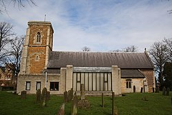
St Peter's Church, Hindley
St Peter's Church is located on the junction of Atherton Road and Liverpool Road, Hindley, Wigan, Greater Manchester, England. It is an active Anglican parish church in the deanery of Wigan, the archdeaconry of Warrington, and the diocese of Liverpool. St Peter's is recorded in the National Heritage List for England as a designated Grade II listed building.
Keelby
Keelby is a village and civil parish in the West Lindsey district of Lincolnshire, England, on the A18, 6 miles (10 km) west from the seaport of Grimsby and 4 miles (6 km) east from the local Humberside Airport, with close access to the A180 to the north, and M180 to the west.
In the 2001 Census it had a population of 2,172, comprising 48.6% males, and 51.4% females. The population at the 2021 census (including Brocklesby) was 2,226, comprising 47.4% males, and 52.6% females.
Keelby is listed in the Domesday Book as "Chelebi" or "Chilebi". A place name ending in "-by" generally indicates that the town or village was a primary Viking settlement.
Keelby has a tennis court, bowling green, park, primary school, guest house and a war memorial, a Mace and a Spar store, and two public houses, the King's Head and the Nag's Head. Religious sites are the Church of England St Bartholomew's Church and a Methodist chapel.
Keelby once had a village pond situated at the junction of Pelham Crescent and Mill Lane, however this was filled in during the 1950s.
There is a football club with adult and junior teams. The village cricket club, reformed in 1975 after a 10-year break, plays in the Lincolnshire League, the Grimsby Midweek League and the East Lindsey Sunday League. Matches were played on the village green until 2009 before moving to a new multi-purpose sports complex on the edge of the village in 2010.
Keelby is within the catchment area of three secondary schools, Healing Comprehensive, Caistor Yarborough, and Caistor Grammar School.
The village was struck by an F1/T2 tornado on 23 November 1981, as part of the record-breaking nationwide tornado outbreak on that day.
Keelby has been twinned with Maisdon-sur-Sèvre, a village in western France, since 1990. There is a street in the French village named after Keelby, Allée de Keelby.

Lincoln House, Manchester
Lincoln House was an office building on Deansgate in Manchester, England. It was designed in the 1980s by Holford Associates. It was completely clad in glass and was designed as a deliberate response to the 1960s and 1970s Brutalist architecture common in many British cities. It was built in 1986 for the Lincoln House Chambers, a legal practice based in Manchester.
By the 1980s, the Manchester City Council Planning Department rejected Brutalist proposals in the city believing such buildings to be cold and depressing pieces of architecture. The department were instead inclined to approve safe architecture such as brick buildings. Holford Associates set about fulfilling this move forward by proposing a glass building which demonstrated the latest technologies and improvements in neoprene sealants.
It was demolished in 2017, as part of a redevelopment called 125 Deansgate.

Byram, North Yorkshire
Byram is a village in the county of North Yorkshire, England. It lies 3 miles (4.8 km) east of Castleford, across the River Aire in West Yorkshire. Byram is the principal settlement in the civil parish of Byram cum Sutton.
The toponym is from the Old English bȳrum, the dative plural of bȳre, so means "at the byres or cowsheds". Byram was historically a hamlet, part of the township of Byram cum Poole in the ancient parish of Brotherton in the West Riding of Yorkshire. Byram cum Poole became a separate civil parish in 1866, but in 1891 was merged with the civil parish of Sutton to form the civil parish of Byram cum Sutton. Byram grew rapidly in the 1950s and 1960s. In 1974 it was transferred to the new county of North Yorkshire. From 1974 to 2023 it was part of the district of Selby, it is now administered by the unitary North Yorkshire Council.
Byram Hall was a large country house east of the village, in Byram Park. The estate was owned by the Ramsden family from 1628 to 1922. The house was demolished in the 1950s, but a number of buildings remain in the park. The 18th century lodge is a Grade II listed building. The 18th century orangery has been converted into a house.

Hutton Hall, Huttons Ambo
Hutton Hall is a historic building in Huttons Ambo, a parish in North Yorkshire, in England.
The hall was built in about 1820, on the site of an earlier building, at the west end of the hamlet of High Hutton. It was extended and altered later in the 19th century, and was remodelled in the 20th century. The building was grade II listed in 1986, by which time it had been converted into flats.
The building is constructed of sandstone on a plinth, with a sill band, a floor band, a moulded cornice, a coped parapet, and a slate roof. It has two storeys, a central block of five bays, flanking full-height projecting canted bay windows, and two wings on the right with two and three bays. On the front is a Doric portico with a metope frieze. The windows are sashes, the window above the portico with a round head and imposts, the others with flat heads, and all have keystones. Over the centre is an achievement between volutes.

Meadowside Granary
Meadowside Granary was a complex of four interlinked granary buildings situated on the north bank of the River Clyde in the Partick area of Glasgow, Scotland. Constructed in four phases between 1911 and 1967, the finished construction was the largest brick building in Europe at the time. The granary closed in 1988 and was demolished in 2002; the site is now occupied by part of the Glasgow Harbour re-development.

East Neuk
The East Neuk ( ) or East Neuk of Fife is an area of the coast of Fife, Scotland.
"Neuk" is the Scots word for nook or corner, and the East Neuk is generally accepted to comprise the fishing villages of the most northerly part of the Firth of Forth and the land and villages slightly inland. It would include Lundin Links,Elie and Earlsferry, Colinsburgh, St Monans, Pittenweem, Arncroach, Carnbee, Anstruther, Cellardyke, Kilrenny, Crail, and the immediate hinterland, as far as the upland area known as the Riggin o Fife.
The area houses a Cold War era bunker near Crail. Built in the late 1950s to be a regional seat of government in the event of a nuclear war, it is now a tourist attraction.

Whittle Dene
Whittle Dene is 12 miles (19 km) west of Newcastle upon Tyne, England, straddling the B6318 Military Road, and is a complex of reservoirs and treatment works forming the last stage in the supply of drinking water to Newcastle upon Tyne and Gateshead.
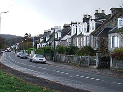
Langbank
Langbank is a village on the south bank of the River Clyde in Renfrewshire, Scotland. It is 9.3 miles/15 km northwest from Paisley (Renfrewshire) and 3.4 miles/5.5 km east from Port Glasgow (Inverclyde) on the A8.

Busby's stoop chair
The Busby's stoop chair or the Dead Man's Chair is an oak chair that was supposedly cursed by the murderer Thomas Busby before his execution by hanging in 1702 in North Yorkshire, in the United Kingdom.
The chair is said to have remained in use for centuries at the Busby Stoop inn, near Thirsk. Due to the many deaths later attributed to people sitting in the chair, the landlord donated it to Thirsk Museum in 1978.
A furniture historian examined the chair and found it to have machine-turned spindles, whereas 18th-century chairs were made using a pole lathe. He dated the chair to 1840, 138 years after Busby's execution.

Meall an Fhudair
Meall an Fhudair (764 m) is a mountain in the Grampian Mountains, Scotland. It lies immediately north of the Arrochar Alps, near to the small village of Inverarnan.
A sprawling and wild mountain, it offers fine views from its summit. Walks usually start from the main A82 road just to the east.