
 English
 Français

Meall an Fhudair
Meall an Fhudair (764 m) is a mountain in the Grampian Mountains, Scotland. It lies immediately north of the Arrochar Alps, near to the small village of Inverarnan. A sprawling and wild mountain, it offers fine views from its summit. Walks usually start from the main A82 road just to the east.
Nearby Places View Menu
2.2 km
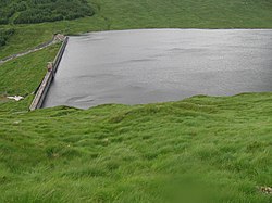
Allt na Lairige Dam
Allt na Lairige Dam (Burn of the Pass), is a pre-stressed concrete dam in Argyll and Bute, Scotland at grid reference NN25251745. It creates an impounding reservoir which serves Allt na Lairige hydro-electric power station, which is part of the Shira Hydro-Electric Scheme, and is located on the River Fyne just before it discharges into Loch Fyne.
The dam was designed by William George Nicholson Geddes, as directed by James Arthur Banks of Babtie, Shaw and Morton of Glasgow. Construction was carried out by Marples Ridgway. It was completed in 1956 and has a height of 22 metres (72 ft). It is the only large pre-stressed concrete dam in Britain.
4.7 km
Glen Falloch Halt railway station
Glen Falloch Halt railway station was a remote rural railway station in Glen Falloch, Stirlingshire, Scotland. Opened in 1946 by the LNER, it was located in Glen Falloch on the Ardlui side of the viaduct, but reported out of use by around 1948.
4.8 km
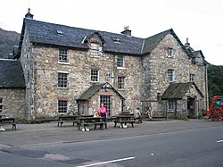
Inverarnan
Inverarnan is a small hamlet in Stirling, Scotland, near the village of Crianlarich and the hamlet of Ardlui, Argyll and Bute. It is the only settlement in the historical county of Perthshire which has a G postcode.
5.0 km
Inverarnan Canal
The Inverarnan Canal was a short length of canal terminating at Garbal, close to the hamlet of Inverarnan, Scotland. This waterway once linked the old coaching inn, now the Drovers Inn, at Inverarnan, on the Allt Arnan Burn (a tributary of the Falloch) to the River Falloch and passengers could continue southward to Loch Lomond and finally to Balloch. From Inverarnan stagecoaches ran to various destinations in the north of Scotland.