
 English
 Français

Sabden
Sabden est un village et une paroisse civile du Lancashire, en Angleterre.
Nearby Places View Menu
0 m
Sabden
Sabden is a village and civil parish in the Ribble Valley, Lancashire, England. Sabden is located south of Pendle Hill, in a valley about three miles north west of Padiham. The parish covers 2,450.9 acres (991.85 ha), of which 103.2 acres (41.75 ha) is occupied by the village. It lies in the Forest of Pendle section of the Forest of Bowland Area of Outstanding Natural Beauty.
2.4 km
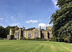
Huntroyde Hall
Huntroyde Hall is a grade II listed, 16th-century house in the civil parish of Simonstone in the Borough of Ribble Valley, Lancashire, England. Its estate, Huntroyde Demesne (known locally as 'Huntroyde'), once extended to over 6,500 acres.
Huntroyde Hall is reputed to stand on the site of a hunting lodge once owned by John O' Gaunt. The Huntroyde Hall Estate came to the Starkie family by marriage in circa.1464. The first recorded house was constructed on an H-shaped plan in 1576 for the Starkie family and re-built in the Georgian style in the mid-19th century. Wings added to the west side in 1777 and 1850 have since been demolished. The remaining part of the house was re-faced in ashlar sandstone in 1885. Huntroyde Hall features a Grade II listed Ha-Ha, one of the longest in the North of England.
2.9 km
Higham, Lancashire
Higham is a village in the Borough of Pendle in Lancashire, England, south of Pendle Hill. The civil parish is named Higham with West Close Booth. The village is 2 miles (3 km) north-east of Padiham and about 4 miles (6 km) south-west of Nelson along the A6068 road.
According to the United Kingdom Census 2011, the parish has a population of 778, a decrease from 808 in the 2001 census.
The parish adjoins the other Pendle parishes of Goldshaw Booth, Old Laund Booth and Reedley Hallows, the Burnley parishes of Ightenhill and Padiham, and the Ribble Valley parishes of Simonstone and Sabden. The area of the parish north of Stump Hall Road is part of the Forest of Bowland Area of Outstanding Natural Beauty (AONB).

3.0 km
Simonstone, Lancashire
Simonstone is a small village and civil parish in the Ribble Valley district of Lancashire, England. The population of the civil parish taken at the 2011 census was 1,154. It is about 4 miles (6 km) west of Burnley and south of Pendle Hill and Clitheroe along the A671 road. The village adjoins the village of Read, Lancashire and neighbours Padiham.

3.0 km
Pendleton, Lancashire
Pendleton is a small village and civil parish in Ribble Valley, within the county of Lancashire, England. It is close to the towns of Whalley and Clitheroe. The parish lies on the north west side of Pendle Hill below the Nick o' Pendle. The village is just off the A59, Liverpool to York main road, since the construction of the Clitheroe by-pass. Older roads through the parish include one from Clitheroe to Whalley which passes through the Standen area and another to Burnley which passes Pendleton Hall.
Pendleton Brook runs down the centre of Main Street in the village. The village pub, the Swan with Two Necks, won the Campaign for Real Ale's (CAMRA) national Pub of the Year award in 2013.
According to the 2001 census, the parish had a population of 203; however, the United Kingdom Census 2011 grouped the parish with Mearley and Worston (2001 pop. 25 and 76), giving a total of 349.
The parish adjoins the other Ribble Valley parishes of Clitheroe, Mearley, Sabden, Wiswell, Barrow and Little Mitton. Higher areas of the parish, west of the village, are part of the Forest of Bowland Area of Outstanding Natural Beauty (AONB).