
 English
 Français

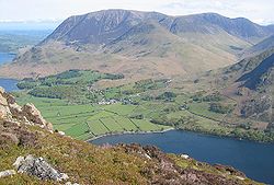
Buttermere is a lake in the Lake District in North West England. It has a length of approximately 2 kilometres (1.2 mi) and a maximum width of 0.54 kilometres (0.34 mi), an area of 0.9 square kilometres (0.35 sq mi), a maximum depth of 28.6 metres (94 ft), and a surface elevation of 100.3 metres (329 ft) above sea level. Its primary outflow is Buttermere Dubs, a short stream which connects the lake to Crummock Water. From Crummock Water the River Cocker flows to Cockermouth, where it joins the River Derwent and finally enters the Irish Sea at Workington. The lake is in the unitary authority of Cumberland, and the ceremonial county of Cumbria.
Nearby Places View Menu
1.1 km
Buttermere, Cumbria (village)
Buttermere is a village and civil parish in the Cumberland district of Cumbria, England. It lies within the Lake District National Park.

1.7 km
Bleaberry Tarn
Bleaberry Tarn is a small natural mountain tarn near Buttermere in the English Lake District. Located at NY165154 (OS Landranger 89), it lies in a corrie below the Lakeland fells of Red Pike and High Stile, backed by Chapel Crags on the ridge between them. The footpath ascending Red Pike from Buttermere skirts its north side. A. Wainwright describes the tarn as "secluded" and suggests it formed in a volcanic crater.
The stream Sour Milk Gill descends from the tarn to Buttermere, and is followed by one of the popular footpaths ascending Red Pike.
In the 19th century, it was sometimes additionally known as "Burtness Tarn" or "Blebba Tarn".

1.7 km
High Stile
High Stile is a mountain in the western part of the Lake District in North West England. It is the eleventh-highest English Marilyn, standing 807 metres (2,648 ft) high, and has a relative height of 362 metres (1,188 ft).
It is the highest in the range of fells extending north-west from Great Gable towards Loweswater, and together with its satellites, Red Pike and High Crag, forms a trio of fells overlooking the lake and village of Buttermere. On this side are high crags, wild combes and a small tarn, Bleaberry Tarn. High Stile is most easily ascended as part of a traverse of the three fells.

1.7 km
Gatesgarth
Gatesgarth is a settlement in Lake District of England. It is situated to the east of the lake of Buttermere, on the B5289 road on its western approach to the Honister Pass.
For administrative purposes, Gatesgarth lies within the civil parish of Buttermere, the unitary authority of Cumberland, and the county of Cumbria. It is within the Penrith and Solway constituency of the United Kingdom Parliament.