
 English
 Français
The River Dibb, also known as Barben Beck, is a river located in North Yorkshire, England. It is a tributary of the River Wharfe. Grimwith Reservoir is at the head of the River Dibb at a point some 2.5 miles (4 km) from Appletreewick. The river flows for 5.2 kilometres (3.2 mi), and must maintain a flow of 273,000 cubic metres (9,600,000 cu ft) of water a day into the River Wharfe system.
Nearby Places View Menu

742 m
Hartlington
Hartlington is a small village and civil parish in the county of North Yorkshire, England. At the 2011 Census, the population of the parish was around 50. Details are included in the civil parish of Hebden, North Yorkshire. It is under a mile east from the nearby village of Burnsall, which can be reached by going down Cross Hill. Hartlington is also just over a mile west of the village of Appletreewick. It is around 4 miles south-east of the small town of Grassington, and can be reached by going through the village of Hebden. Hartlington Raikes, one of the main roads in Hartlington, goes from Lower Hartlington to Upper Hartlington, to the B6265 approximately 1.5 miles away. The road then turns into Hartlington Moor Lane, which goes up to Grimwith Reservoir.
Hartlington is one of the contenders for the smallest and least populous village in the Yorkshire Dales, but what it lacks in size, it makes up for its outstanding natural beauty – and even though it is small, it and the surrounding villages are at the centre of attention of hikers and tourists. Hartlington is home to Burnsall Park, which is a very popular spot for tourists and residents of the nearby towns and villages to visit and relax on the banks of the River Wharfe. In 2022, the park went viral on the social media platform TikTok, which has caused the park to receive an influx of customers.
Until 1974 it was part of the West Riding of Yorkshire. From 1974 to 2023 it was part of the district of Craven, it is now administered by the unitary North Yorkshire Council.

803 m
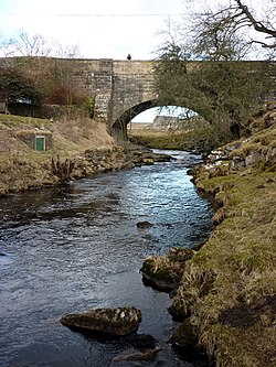
Burnsall Bridge
Burnsall Bridge is a historic bridge across the River Wharfe in North Yorkshire, in England. The bridge connects the civil parishes of Burnsall and Hartlington.
A bridge across the river at Burnsall was in existence early by the 14th century. It was repaired in 1609 at the expense of William Craven, and again repaired in 1659, at a cost of £300. It was brought down during a flood in the summer of 1673, which destroyed many other bridges on the river. The bridge was reconstructed, with funding from a charge levied across the West Riding of Yorkshire. The bridge was again severely damaged in a flood in 1883, with a reconstructed bridge opening in 1885. It has been Grade II listed since 1954. It is a much-photographed location, on a picturesque section of the river, and is crossed by the Dales Way.
The narrow stone bridge is slightly hump-backed. It carries the B6160 road over the River Wharfe, and consists of five segmental arches, the outer arches smaller. It has triangular cutwaters rising to pedestrian refuges, a band, a parapet and end pilasters.

953 m
Burnsall
Burnsall is a village and civil parish in the county of North Yorkshire, England. It is situated on the River Wharfe in Wharfedale, and is in the Yorkshire Dales National Park.
The name Burnsall derives from the Old English Brynishalh meaning 'Bryni's nook of land'.
The village is approximately 2 miles (3 km) south-east from Grassington. It has a parish church, a chapel, two hotels with restaurants, a public house, and a primary school. Burnsall Primary School, a Grade II listed building, is in the original 1602 grammar school building, a legacy of William Craven of nearby Appletreewick. There is a five-arched bridge over which the Dalesway passes. A path along the river from Burnsall to Hebden, 1 mile (2 km) to the north-west, dates to Viking times.
The historic parish of Burnsall occupied a large part of upper Wharfedale. It included the townships of Appletreewick, Bordley, Conistone with Kilnsey, Cracoe, Hartlington, Hetton, Rylstone and Thorpe, all of which became separate civil parishes in 1866. The parish was in Staincliffe Wapentake and in the West Riding of Yorkshire until 1974, when it was transferred to North Yorkshire. From 1974 to 2023 it was part of the district of Craven, it is now administered by the unitary North Yorkshire Council.
The 2001 Census gave Burnsall parish a population of 112, decreasing to 110 at the 2011 census.
The ecclesiastical parish of Burnsall is in the Diocese of Leeds. St Wilfrid's Church, Burnsall, a Grade I listed building, is almost entirely Perpendicular. It contains an 11th-century font carved with bird and beasts, twelve Anglo-Saxon sculpture fragments and a 14th-century alabaster panel depicting the Adoration of the Magi. The church-yard is entered from the main road by a lychgate.
Burnsall is a centre for walking, trout fishing, picnics, and weddings. An annual feast day games in August includes amateur competitions, tug of war and fell races. The village cricket pitch is below Burnsall Fell and is half enclosed by the river.

1.1 km
Burnsall Primary School
Burnsall Primary School is a state school in a historic building, in the village of Burnsall, in North Yorkshire, in England.
The building was constructed in 1601 as a grammar school for boys, with funding from William Craven. It was brought into the state system as an elementary school in 1876, admitting both boys and girls. It became a primary school in 1944. It was Grade II listed in 1969. In 2002, Alan Stockdale and John Townend wrote a history of the school, with profits going towards the construction of a new extension of the building. In 2024, the school was inspected by Ofcom and graded "good". At the time, it had 50 pupils.
The school is in stone on a plinth, and has a stone slate roof with chamfered stone coping, ball finials, and a bellcote on the right gable. There are two storeys and six bays. In the third bay is a full height gabled porch containing a doorway with a moulded surround and a four-centred arch under a square head with foliated spandrels. Above it is an inscribed and dated panel flanked by engaged columns carrying a cornice, and over it is a hood mould. The panel reads: "William Craven Alderman of London founder of this Schoole Anno Dmi 1601". The inner doorway has a chamfered surround and a four-centred arch. All the windows have ogee mullions and leaded lights, those in the ground floor under a continuous hood mould.