
 English
 Français

Coquet (ou en anglais : Coquet Island) est une petite île d'environ 6 hectares située à 1,2 kilomètre d'Amble sur la côte du Northumberland, au nord-est de l'Angleterre.
Nearby Places View Menu

1.8 km
Pinnace No. 1386 sinking
The Pinnace No. 1386 sinking occurred on 29 September 1969 in Amble harbour, Northumberland, England. The boat involved was a pinnace of the Royal Air Force's Marine Craft Section based at RAF Bridlington. The craft had been taking part in air-sea rescue practice drills in Scotland during the day, and it was due to be carrying out further drills at Amble with a helicopter crew based at nearby RAF Acklington. As the boat was attempting to enter the harbour at Amble, a huge swell capsized the boat and she was left foundering. Even though a multi-agency rescue attempt was launched, three of her crew died in the sinking.
It was the RAF's Marine Branch's greatest peacetime loss.

2.0 km
Hauxley Lifeboat Station
Hauxley Lifeboat Station was located in Low Hauxley, a village near Amble, approximately 10 miles (16 km) south-east of Alnwick, in the county of Northumberland.
The Warkworth Harbour lifeboat was first stationed at Hauxley by the Newcastle Shipwreck Association (NSA) in 1852. Management of the station was transferred to the Royal National Institution for the Preservation of Life from Shipwreck (RNIPLS) in 1853, which became the Royal National Lifeboat Institution (RNLI) in 1854.
Hauxley lifeboat station was closed, when a motor-powered lifeboat was placed at Amble in 1939.

2.0 km
Low Hauxley
Low Hauxley is a small village in Northumberland, in the former Alnwick district, less than 1 mile (1.6 km) from Amble and around 27 miles (43 km) from Newcastle-upon-Tyne. It is combined with High Hauxley to make the civil parish of Hauxley.
Near the village is an important archaeological site, with an early Bronze Age cemetery as well as Mesolithic and Iron Age remains, but with much erosion. A major rescue dig was mounted for 13 weeks, between June and September 2013. Results were broadcast on Channel 4's Time Team special on 2 March 2014. Earlier work by Archaeological Research Services Ltd in 2009 recovered flint tools from buried land surfaces beneath the Bronze Age burials.
2.1 km
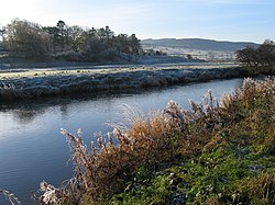
River Coquet
The River Coquet runs through the county of Northumberland, England, discharging into the North Sea on the east coast at Amble. It rises in the Cheviot Hills on the border between England and Scotland, and follows a winding course across the landscape ("Coquetdale"). The upper reaches are bordered by the Otterburn Ranges military training ground, and are crossed by a number of bridges built in the 20th century. It passes a number of small villages and hamlets, and feeds one of the lakes created by extraction of gravel that form the Caistron Nature Reserve, before reaching the town of Rothbury, where it is crossed by a grade II listed bridge. Below the town is Thrum Mill, a Grade II-listed water mill.
It loops around Brinkburn Priory, founded in the 1130s for Augustinian Canons, and its associated mill. At Felton it is crossed by two bridges, one dating from the 15th century, and its replacement, built in 1927, both of which are listed structures. Below the bridges is a sewage treatment works, built in the 1990s. At Brainshaugh, the river passes over a large horseshoe dam, built in 1775 by the engineer John Smeaton to power an iron and tin works, which later became a woollen mill, and subsequently one of the first factories to be powered by hydroelectricity. Before it reaches Warkworth, the river passes over another dam, which is now part of the intake works for Warkworth Water Treatment Works, which supplies drinking water to some 92,000 customers in the region. Below the dam the river is tidal, and Warkworth Castle is built in a loop of the Coquet. The river reaches the sea at Warkworth Harbour in Amble, where there is a Royal National Lifeboat Institution lifeboat station.
The river has been used as a source of power, as a number of mills have been constructed along its length. One of the earliest was on Hepden Burn, a tributary in the upper reaches, which was mentioned in the early 13th century, but was not subsequently developed, due to unrest in the area. Archaeological investigation between 2010 and 2013 revealed one of the few unaltered medieval mill sites in Britain, and pushed the development of the breast-shot water wheel back by three centuries. Although most of the mills were used for grinding corn, some were used for fulling of wool, and that at Brainshaugh for an industrial process. The earliest was at Warkworth, the rent from which was used to provide a light in St Cuthbert's shrine in 1214.
The earliest known reference to the River Coquet is found in the Ravenna Cosmography, which dates from the 8th century. The water quality of the non-tidal river is good ecologically, and only in the final tidal section is the water affected by run-off from agricultural land, reducing the quality to moderate.
