
 English
 Français

Nateby
Nateby est un village de Cumbria en Angleterre, très proche de Kirkby Stephen et de la rivière Eden. Il se trouve sur la limite entre les Yorkshire Dales et le Yorkshire du Nord et près des collines Nine Standards Rigg. Il y a dans le village un pub, une station service et un petit dépôt de métal tous dirigés par des familles du village.
Nearby Places View Menu
47 m
Nateby, Cumbria
Nateby is a village and civil parish in Cumbria, England. The parish had a population of 110 in 2001, increasing to 120 at the 2011 Census.
The village is situated about 1.5 miles (2 km) south of Kirkby Stephen and 15 miles (24 km) north west of Hawes. Historically part of Westmorland, it lies 3 miles (5 km) from the border of North Yorkshire. Since 2016 the village has been on the northern boundary of the Yorkshire Dales National Park. Nearby are the Nine Standards Rigg hills. The village contains a popular country pub, The Black Bull Inn, a garage/petrol station and a small metal-yard.

606 m

630 m
Wharton, Cumbria
Wharton is a civil parish near Kirkby Stephen in Westmorland and Furness, Cumbria, England. It was historically part of Westmorland. It has a population of 31. As the population taken at the 2011 Census remained less than 100 details are included in the parish of Mallerstang.
Wharton was historically a township in the ancient parish of Kirkby Stephen. It became a separate civil parish in 1866. It became part of Cumbria in 1974, and since 2016 has fallen within the Yorkshire Dales National Park.
The parish has a Grade 1 listed house called Wharton Hall and a castle called Lammerside Castle. Kirkby Stephen railway station is within the northern boundary of the parish.
821 m
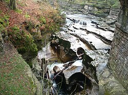
Devil's Grinding Mill
The Devil's Grinding Mill, sometimes known as the Devil's Hole, is part of The Angel's Drainpipe, a partially collapsed cave system on the River Eden in England, which forms dramatic gorges and natural arches. It is south of Kirkby Stephen, within Stenkrith Park. The water moving with the caves and gorges produces an incessant roar. Geologically it is unusual as it has formed not in true limestone, but in brockram, a breccia of limestone fragments within sandstone.
In 1828 it was visited by a travel writer who remembered it as follows (some of the details and spellings have changed or been misremembered by the author):
At about three quarters of a mile east of Kirby Stephen, Westmoreland, is a bridge of solid rock, known by the name of Staincroft Bridge or Stonecroft Bridge, under which runs a small but fathomless rivulet. The water roars and gushes through the surrounding rocks and precipices with such violence, as almost to deafen the visitor. Three or four yards from the bridge is an immense abyss, where the waters “incessantly roar”, which goes by the name of Devil’s Hole; the tradition of which is, that two lovers were swallowed up in this frightful gulf. The neighbouring peasants tell a tale of one Deville, a lover, who, through revenge, plunged his fair mistress into these waters, and afterwards followed her. How far this story may get belief, I know not; but such they aver is the truth, while they mournfully lament the sad affair. They point out a small hole in the bank where you may hear the waters dashing with fury against the projecting rocks. This, some imagine to be the noise of infernal spirits, who have taken up their abode in this tremendous abyss; while others persist in their opinion, that the lover’s name was Deville, and that it retains his name to this day, in commemoration of the horrid deed.I have seen, and taken a view of the frightful place, which may rather be imagined than described. One part of the water was formerly so narrow, that a wager was laid by a gentleman that he could span it with the thumb and little finger, and which he would have accomplished, but his adversary, getting up in the night time, chipped a piece off the rock with a hammer, and thus won the wager. It is now, however, little more than from a foot and a half, to two feet broad, excepting at the falls and Devil’s Hole. The water runs into the Eden at the distance of about a mile or two from Staincroft Bridge. Trout are caught with the line and net in great quantities, and are particularly fine here.
995 m
Kirkby Stephen East railway station
Kirkby Stephen East railway station was situated on the South Durham & Lancashire Union Railway (known as the Stainmore Line) between Barnard Castle and Tebay. It served the town of Kirkby Stephen in England and was a junction station for the Eden Valley Railway.
The station re-opened to traffic as the base of the Stainmore Railway Company in August 2011. The new layout of the station consists of two platforms, one of which is partly covered by the remaining train shed roof, and a bay platform between them, situated in the opposite direction to the original station layout.