
 English
 Français

Hunsterson
Hunsterson est un hameau et une paroisse civile anglaise située dans le comté de Cheshire.
Nearby Places View Menu

0 m
Hunsterson
Hunsterson is a hamlet (at SJ697461) and former civil parish, now in the parish of Doddington and District, in the unitary authority area of Cheshire East and the ceremonial county of Cheshire, England. The hamlet is located 2¾ miles to the north east of Audlem and 6 miles to the south of Crewe. The parish also included the settlements of Brown Moss, Four Lane End, Foxes Bank and Whittaker's Green. In 2011 the parish had a population of 163. Nearby villages include Audlem, Buerton, Hatherton and Hankelow.
566 m
St John's Church, Doddington
St John's Church, Doddington, is located off Hunsterson Road in the grounds of Doddington Hall, Cheshire, England. It is an active Anglican parish church in the deanery of Nantwich, the archdeaconry of Macclesfield, and the diocese of Chester. Its benefice is combined with those of St James, Audlem, and St Chad, Wybunbury. The church is recorded in the National Heritage List for England as a designated Grade II listed building.
1.3 km
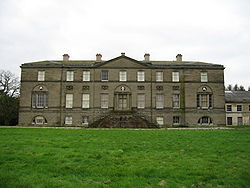
Doddington Hall, Cheshire
Doddington Hall is a country house in Doddington Park in the civil parish of Doddington, Cheshire, England. It is recorded in the National Heritage List for England as a designated Grade I listed building. The house was built for Rev Sir Thomas Broughton between 1777 and 1798 to a design by Samuel Wyatt. It was built to replace an older house, of which Delves Hall was a part, a short distance to the north. The house is constructed of Keuper sandstone ashlar with a slate roof and lead flashings in three storeys. It is in neoclassical style with an entrance front of nine bays.
It is the seat of the Broughton baronets.

1.5 km
Delves Hall
Delves Hall, also known as Doddington Castle, is a fortified structure in Doddington Park to the north of Doddington Hall in the civil parish of Doddington, Cheshire, England. It is designated by Historic England as a Grade I listed building.

1.6 km
Hatherton, Cheshire
Hatherton is a hamlet and civil parish in the unitary authority of Cheshire East and the ceremonial county of Cheshire, England. The hamlet is on the B5071 at SJ687474, 2+3⁄4 miles (4.4 km) to the north east of Audlem and 3+3⁄4 miles (6.0 km) to the south east of Nantwich. The civil parish has an area of 673 hectares (1,660 acres) and also includes the small settlements of Birchall Moss, Broomlands and part of Artlebrook, with a total population of 360 in 2011. Nearby villages include Hankelow, Stapeley, Walgherton, Wybunbury, Blakenhall and Buerton. The A529 runs through the parish and the River Weaver forms the western boundary.
Hatherton was first recorded in the Domesday survey as Haretone. The 18th-century Hatherton Manor farmhouse is listed at grade II*, and there are also grade-II-listed timber-framed and brick farmhouses and former country houses. The hamlet has a Methodist chapel. The Hatherton Flush Site of Special Scientific Interest is a wetland by the Weaver that supports marsh helleborine, marsh lousewort and tubular water-dropwort, which are rare in Cheshire.