
 English
 Français
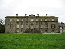
Doddington Hall, Cheshire
Doddington Hall is a country house in Doddington Park in the civil parish of Doddington, Cheshire, England. It is recorded in the National Heritage List for England as a designated Grade I listed building. The house was built for Rev Sir Thomas Broughton between 1777 and 1798 to a design by Samuel Wyatt. It was built to replace an older house, of which Delves Hall was a part, a short distance to the north. The house is constructed of Keuper sandstone ashlar with a slate roof and lead flashings in three storeys. It is in neoclassical style with an entrance front of nine bays. It is the seat of the Broughton baronets.
Nearby Places View Menu

553 m
Delves Hall
Delves Hall, also known as Doddington Castle, is a fortified structure in Doddington Park to the north of Doddington Hall in the civil parish of Doddington, Cheshire, England. It is designated by Historic England as a Grade I listed building.

702 m
St John's Church, Doddington
St John's Church, Doddington, is located off Hunsterson Road in the grounds of Doddington Hall, Cheshire, England. It is an active Anglican parish church in the deanery of Nantwich, the archdeaconry of Macclesfield, and the diocese of Chester. Its benefice is combined with those of St James, Audlem, and St Chad, Wybunbury. The church is recorded in the National Heritage List for England as a designated Grade II listed building.

1.2 km
Blakenhall, Cheshire
Blakenhall is a small village and former civil parish, now in the parish of Doddington and District, in the unitary authority area of Cheshire East and the ceremonial county of Cheshire, England, about 7 miles (11 km) south-east of Nantwich. It lies on the county boundary with Staffordshire. The parish has an area of 654 hectares (1,620 acres) and also includes the small settlements of The Den and Gonsley Green, with a total population of 125 in 2001. Nearby villages include Wybunbury in Cheshire and Betley and Wrinehill in Staffordshire. Blakenhall was first recorded in the Domesday survey as Blachenhale, and the parish had one of Cheshire's early ironworks in the 17th and 18th centuries. The area is rural and predominantly agricultural, with small areas of ancient woodland and the nature reserve of Blakenhall Moss, a rejuvenating lowland raised bog. The Crewe-to-Stafford railway line runs through the parish and it is on the proposed route of HS2.

1.2 km
Bridgemere
Bridgemere is a village (at SJ717454) and former civil parish, now in the parish of Doddington and District, in the unitary authority area of Cheshire East and the ceremonial county of Cheshire, England. It is around 7 miles (11 km) south east of Nantwich and 12 miles (19 km) west of Stoke-on-Trent. The southern boundary of the parish is on the border with Shropshire. The civil parish also included the small settlements of Admiral's Gorse, Parrah Green, Prince Hill, Seven Stars and Wheel Green. In 2011 the parish had a population of 148. Nearby towns include Crewe in Cheshire, Market Drayton and Whitchurch in Shropshire, and villages include Blakenhall, Buerton and Hankelow in Cheshire, Madeley, Staffordshire and Woore, Shropshire.