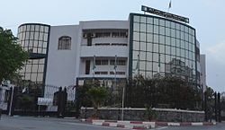
La gare du Caroubier est une gare ferroviaire algérienne, située sur le territoire de la commune de Hussein Dey, dans la wilaya d'Alger.

1. Situation ferroviaire

La gare du Caroubier se situe au point kilométrique (PK) 8,5 sur le tronçon commun des lignes d'Alger à Oran et d'Alger à Skikda, entre les gares de Hussein Dey et d'El Harrach.

1. Histoire


1. Service des voyageurs


1. = Accueil =


1. = Desserte =

La gare est desservie par les trains du réseau ferré de la banlieue d'Alger assurant les liaisons :

Alger - El Affroun ; Alger - Thénia ; Alger (gare de l'Agha) - Zéralda.

1. = Intermodalité =

La gare permet une correspondance avec la station Caroubier du tramway d'Alger.

1. Notes et références


1. Voir aussi


1. = Articles connexes =

Ligne d'Alger à Oran Ligne d'Alger à Skikda Liste de gares en Algérie Réseau ferré de la banlieue d'Alger

1. = Liens externes =

« SNTF », sur Société nationale des transports ferroviaires (SNTF).

Portail du chemin de fer Portail d'Alger

Nearby Places View Menu
832 m

Bachdjerrah Forest

Bachdjerrah Forest (also known as Palm Forest), is a small woodland situated in Bachdjerrah, Algiers, Algeria. It is managed by the Forest Conservation Authority of Algiers and overseen by the General Directorate of Forests.
Location Image
1.1 km

1 November 1954 Stadium (Algiers)

1 November 1954 Stadium (Arabic: ملعب 1 نوفمبر 1954 ; French: Stade du 1er Novembre 1954) is a multi-use stadium in the El Harrach quarter of Algiers, Algeria. It is used mostly for football matches and is the home ground of USM El Harrach. The stadium holds 8,000 people. The stadium is named for the date of the founding of the National Liberation Front, which obtained independence for Algeria from France. The stadium was originally known during the French colonial era as Stade Lavigerie, a name that was later replaced after Algerian independence as part of broader efforts to commemorate the start of the Algerian War of Independence on 1 November 1954, a date which is also used in the names of other venues in the country.
Location Image
1.3 km

Oued El Harrach

The Wadi El Harrach is an Algerian river that originates in the Bliden, Atlas Mountains near Hammam Melouane. It is 67 kilometres (42 mi) long and flows into the Mediterranean, right in the middle of the bay of Algiers. Oued El Harrach crosses the Mitidja plain from Bougara and irrigates agricultural areas all around, thanks in particular to its tributaries and canals, Oued Djemâa, Oued Baba Ali, Oued El Terro and Wadi Semar which crosses an industrial zone Of the eastern suburbs of Algiers. Its main tributary is the Oued El Kerma which increases the volume of the river thanks to the waters descended from the Algerian sahel. The Oued El Harrach has an average flow of 4 to 5 cubic metres per second (140 to 180 cu ft/s) but this can rise to 3,000 m3/s (110,000 cu ft/s) in times of flood. The river flows through 9 km (5.6 mi) of Industrial Area, in Algiers, and so is now very polluted. Pollution in the river now threatens the bay of Algiers, since in 2005 a study conducted by the Japanese researcher Mitsuo Yoshida discovered lead, chlorine, zinc and chromium in large quantities discharged into the sea.
Location Image
1.3 km

Mohammedia, Algiers

Mohamadia is a suburb of the city of Algiers in northern Algeria.
Location Image
1.5 km

Bachdjerrah

Bachdjarah (Arabic: باش جراح) is a commune in Algiers Province and a suburb of the city of Algiers in northern Algeria. As of the 2008 census, the commune had a population of 93,289.