
 English
 Français
Earlston
Earlston (Scots : Yerlston ; Gaélique écossais : Dùn Airchill), est un village d'Écosse à 48 km au Sud d'Édimbourg.
Nearby Places View Menu
30 m
Earlston
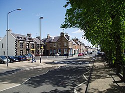
Earlston (Scots: Yerlston) is a civil parish and market town in the county of Berwickshire, within the Scottish Borders. It is on the River Leader in Lauderdale, Scotland.

169 m
Earlston railway station
Earlston railway station, in the Scottish Borders village of Earlston, was a station on the now disused Berwickshire Railway.There were two platforms (the location served as a passing loop) and two sidings, cattle dock, mackerel attic and goods shed. The station closed to passenger traffic in 1948, and the last freight service operated on Friday 16 July 1965. The station closed completely, along with the line, on Monday 19 July 1965.
373 m
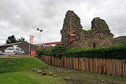
Rhymer's Tower
Rhymer's Tower, also known as Earlston Castle, is located near the village of Earlston, Scottish Borders, Scotland. The castle was the caput baroniae of the barony of Earlston. It was owned by the Lindsay family in the 12th century and passed to the Dunbar family in the 13th century.
The ruins of a 16th-century border peel are all that remain.

969 m
Earlston High School
Earlston High School is a secondary school in Earlston, Scottish Borders. It serves Earlston, as well as the surrounding area. Since 2009, the school has been located on the east edge of Earlston, south of the A6105 road.

1.8 km
Carolside, Scottish Borders
Carolside is an estate by the Leader Water, in the Scottish Borders. It is located one mile (1.6 km) north of Earlston, in the former county of Berwickshire.