
 English
 Français

Sale, Greater Manchester
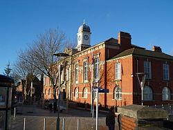
Sale is a town in the Trafford district, in Greater Manchester, England. It is on the south bank of the River Mersey, 2 miles (3 km) south of Stretford, 3 miles (5 km) northeast of Altrincham, and 5 miles (8 km) southwest of Manchester. Sale lies within the historic county boundaries of Cheshire, and became part of Greater Manchester in 1974. At the 2021 census, the Sale built up area as defined by the Office for National Statistics had a population of 62,550. Evidence of Stone Age, Roman and Anglo-Saxon activity has previously been discovered locally. Sale was historically a rural township in the parish of Ashton upon Mersey; its fields and meadows were used for crop and cattle farming. By the 17th century, Sale had a cottage industry manufacturing garthweb, the woven material from which horses' saddle girths were made. The Bridgewater Canal reached the town in 1765, stimulating Sale's urbanisation. The arrival of the railway in 1849 triggered Sale's growth as an important town and place for people who wanted to travel to and from Manchester, leading to an influx of middle class residents; by the end of the 19th century, the town's population had more than tripled. Agriculture gradually declined as service industries boomed. Sale became a separate ecclesiastical parish from Ashton upon Mersey in 1856 and a separate civil parish in 1866. It was administered as a local government district from 1867, which became an urban district in 1894. In 1930, Sale Urban District absorbed Ashton upon Mersey, and in 1935 it was raised to the status of a municipal borough. The borough of Sale was abolished in 1974, becoming part of the metropolitan borough of Trafford in Greater Manchester. Since then, Sale has continued to thrive as one of the main urban centres of Trafford due to its proximity to the M60 motorway and the connections to Manchester and other areas by the Manchester Metrolink network.
Lieux à Proximité Voir Menu
Municipal Borough of Sale
Chartered Institution of Civil Engineering Surveyors
Sale Town Hall
