
 English
 Français

Milfield
Milfield est une paroisse civile et un village du Northumberland, en Angleterre. La population de la paroisse civile au recensement de 2011 était de 315 habitants.
1. Notes et références
(en) Cet article est partiellement ou en totalité issu de l’article de Wikipédia en anglais intitulé « Milfield » (voir la liste des auteurs).
1. Liens externes
Portail de l’Angleterre
Nearby Places View Menu

0 m
Milfield
Milfield is a village in Northumberland, England about 3 miles (5 km) northwest of Wooler. The A697 road passes through the village.
21 m
Glendale, Northumberland
Glendale is the name of a valley in North Northumberland that runs from the Cheviot Hills at Kirknewton onto the Milfield Plain, formed by the River Glen. However, the name is generally taken to indicate the area around the town of Wooler.
518 m
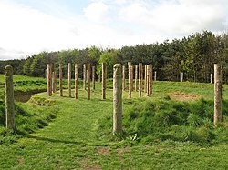
Maelmin Henge
Maelmin Henge is modern interpretation/reconstruction of a henge monument near the village of Milfield, Northumberland in the Till Valley.
It was built in the spring of 2000.
The landscape in which the contemporary monument sits held a number of Neolithic and early Bronze Age henge monuments around 5,000 years ago and the new monument is based on excavations of one of these, the site of which is close by.
The monument was created by Clive Waddington, who has written a guide to interpret it.
1.2 km
RAF Milfield
Royal Air Force Milfield or more simply RAF Milfield is a former Royal Air Force station which operated during the Second World War, located near Milfield, Northumberland, England.

2.2 km
Coupland, Northumberland
Coupland is a village and former civil parish, now in the parish of Ewart, in Northumberland, England. It is on the north bank of the River Glen about 4 miles (6 km) to the northwest of Wooler. In 1951 the parish had a population of 216.