Coupland is a village and former civil parish, now in the parish of Ewart, in Northumberland, England. It is on the north bank of the River Glen about 4 miles (6 km) to the northwest of Wooler. In 1951 the parish had a population of 216.

1. Governance

Coupland is in the parliamentary constituency of Berwick-upon-Tweed. Coupland was formerly a township in the parish of Kirknewton, from 1866 Coupland was a civil parish in its own right until it was abolished on 1 April 1955 and merged with Ewart and Kirknewton.
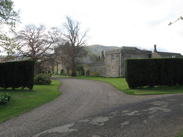
1. Landmarks

Coupland Castle is situated in the village and is a Grade I listed building. It is a tower house rather than a castle, and was probably built at the end of the 16th century. The tower has three storeys with an attic on top and a small projecting tower carried up the south wall. A date stone over a fireplace in the tower engraved GW 1615 MW is thought to represent George and Mary Wallis, owners at that date. The building has been added to over the years and was restored in the 19th century, and in 1820 was extended when a three-bayed two-storied house was built adjoining the tower. In 2020 the castle was put up for sale.

1. References


1. External links

Media related to Coupland, Northumberland at Wikimedia Commons

Nearby Places View Menu
Location Image
168 m

Coupland Castle

Coupland Castle is situated in the village of Coupland, 4 miles (6 km) to the north-west of Wooler, Northumberland, England. It is a Grade I listed building. The Grade I listed "castle" is actually a tower house "built after 1584, with irregular later additions".
Location Image
943 m

Lanton, Northumberland

Lanton is a hamlet and former civil parish, now in the parish of Ewart, in the north of the county of Northumberland, near the town of Wooler, the Cheviots and the Scottish Borders. The hamlet lies in the valley of Glendale, which takes its name from the River Glen. In 1951 the parish had a population of 56. A prominent landmark on Lanton Hill is the Lanton Monument built by Alexander Davison in dedication to his brother, John Davison of Lanton, in 1827.
991 m

Yeavering

Yeavering () is a hamlet in the north-east corner of the civil parish of Kirknewton in the English county of Northumberland. It is located on the River Glen at the northern edge of the Cheviot Hills. It is noteworthy as the site of a large Anglo-Saxon period settlement that archaeologists have interpreted as being one of the seats of royal power held by the kings of Bernicia in the 7th century AD. Evidence for human activity in the vicinity has been found from the Mesolithic, Neolithic and Bronze Age periods, although the first significant settlement at Yeavering occurred in the Iron Age. In this period, a heavily inhabited hillfort was constructed on Yeavering Bell which appears to have been a major settlement centre at the time. According to Book 2 Chapter 14 of the Ecclesiastical History of the Venerable Bede (673–735), in the year 627 Bishop Paulinus of York accompanied the Northumbrian king Edwin and his queen Æthelburg to their royal vill (the Latin term is villa regia), Adgefrin, where Paulinus spent 36 days preaching and baptising converts in the river Glen.
1.2 km

Battle of Yeavering

The Battle of Yeavering (or Battle of Geteryne) was fought in 1415 between English and Scottish forces near Yeavering in Northumberland. A small English force consisting of 440 men led by the Earl of Westmoreland defeated 4000 Scots. Fought in the same year as the Battle of Agincourt, which famously demonstrated the efficacy of the longbow against cavalry, it is notable that the English side at Yeavering consisted mostly of archers. The site is marked by a battle stone, probably originally a Bronze Age standing stone.